


1 Introduction
A unified Chart Datum for the whole Baltic Sea is required for the use of global navigation satellite systems (GNSS) in accurate 3-D bathymetric surveying and navigation, enabling for automated shipping with increased efficiency and improved maritime safety. So far, the zero levels of nautical maps were derived from the mean sea level (MSL) of different local tide gauges. The inherent height datum differences between neighboring map sheets are a fundamental infrastructural obstacle for implementing and using new cross-border navigation services based on electronic nautical maps. The Baltic Sea Hydrographic Commission, with its Chart Datum, Water Level and Currents Working Group (CDWCWG), has therefore decided to implement a harmonized vertical reference in the Baltic Sea (BSHC18 conference, 2013; Schwabe et al., 2020) called the Baltic Sea Chart Datum 2000 (BSCD2000). The first milestone was the agreement between the Baltic Sea countries on the fundamental standards of the BSCD2000, the general features of its practical realization, and the roadmap for the transition and implementation of the new chart datum (CDWG8, 2016).
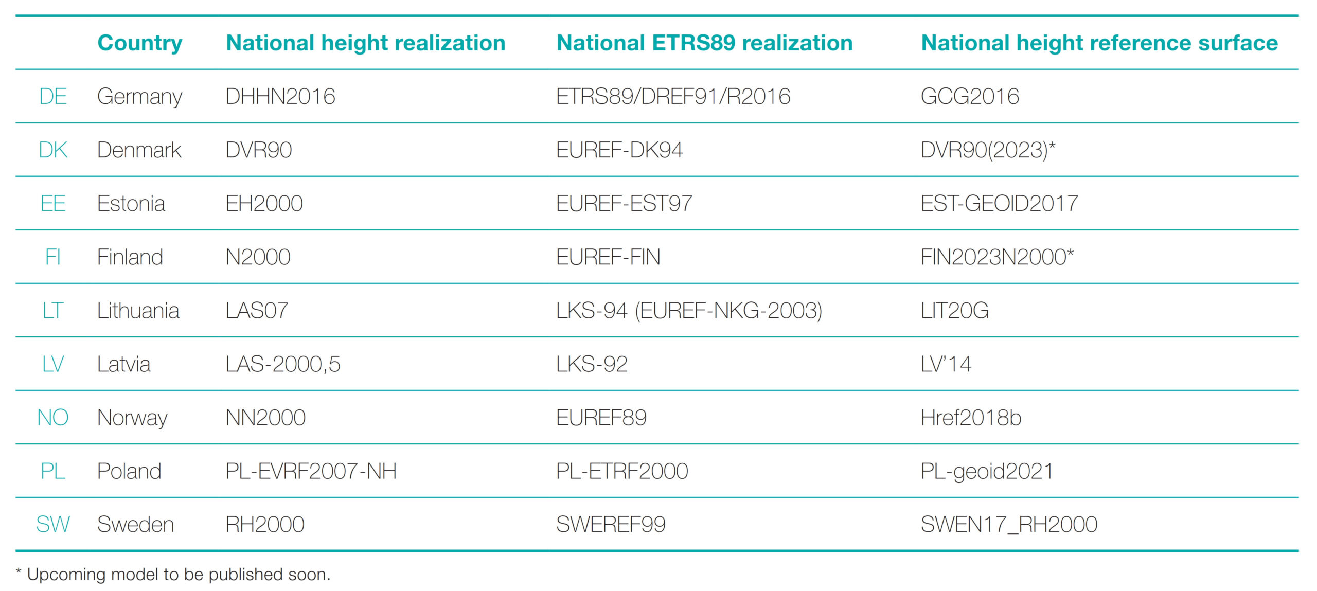
According to this, the BSCD2000 adopts already established European geodetic standards for coordinates and heights, i.e., the European Terrestrial Reference System 1989 (ETRS89; EUREF, 1990) and the European Vertical Reference System (EVRS; Ihde et al., 2007; Sacher & Liebsch, 2019). The zero level – like for most national height systems around the Baltic Sea – is defined by the Normaal Amsterdams Peil (NAP). Thus, it does not coincide anymore with the local MSL. The practical realization of BSCD2000 is based – as far as possible – on the national geodetic reference frames, data and services (BSCD2000 Specifications, first draft 2016; last updated as in Ågren et al., 2023). An overview of the national realizations is provided in Table 1.
The essential component for the practical realization of the BSCD2000 is a model of the unified height reference surface for the whole Baltic Sea region – the geoid. Comparable national models have become available in the participating countries (sometimes covering the land parts only) and are used for GNSS- based height determination in numerous applications. Modern and quality-controlled gravity surveys are a prerequisite to modeling the geoid accurately. Due to the logistical challenges of marine gravimetric surveys, the available information for the geoid modeling in the Baltic Sea area has been incomplete and partly outdated and did not fulfill the current requirements.
Under the framework of the project FAMOS (Finalizing Surveys for the Baltic Motorways of the Sea) co-funded by the European Union (EU), large parts of the Baltic Sea could be remeasured or even measured for the first time (e.g., Liebsch et al., 2022). Data exchange and cooperation were stimulated, including a new pooling of the data (gravity database hosted at DTU Space, maintained by Gabriel Strykowski) and cross-checking.
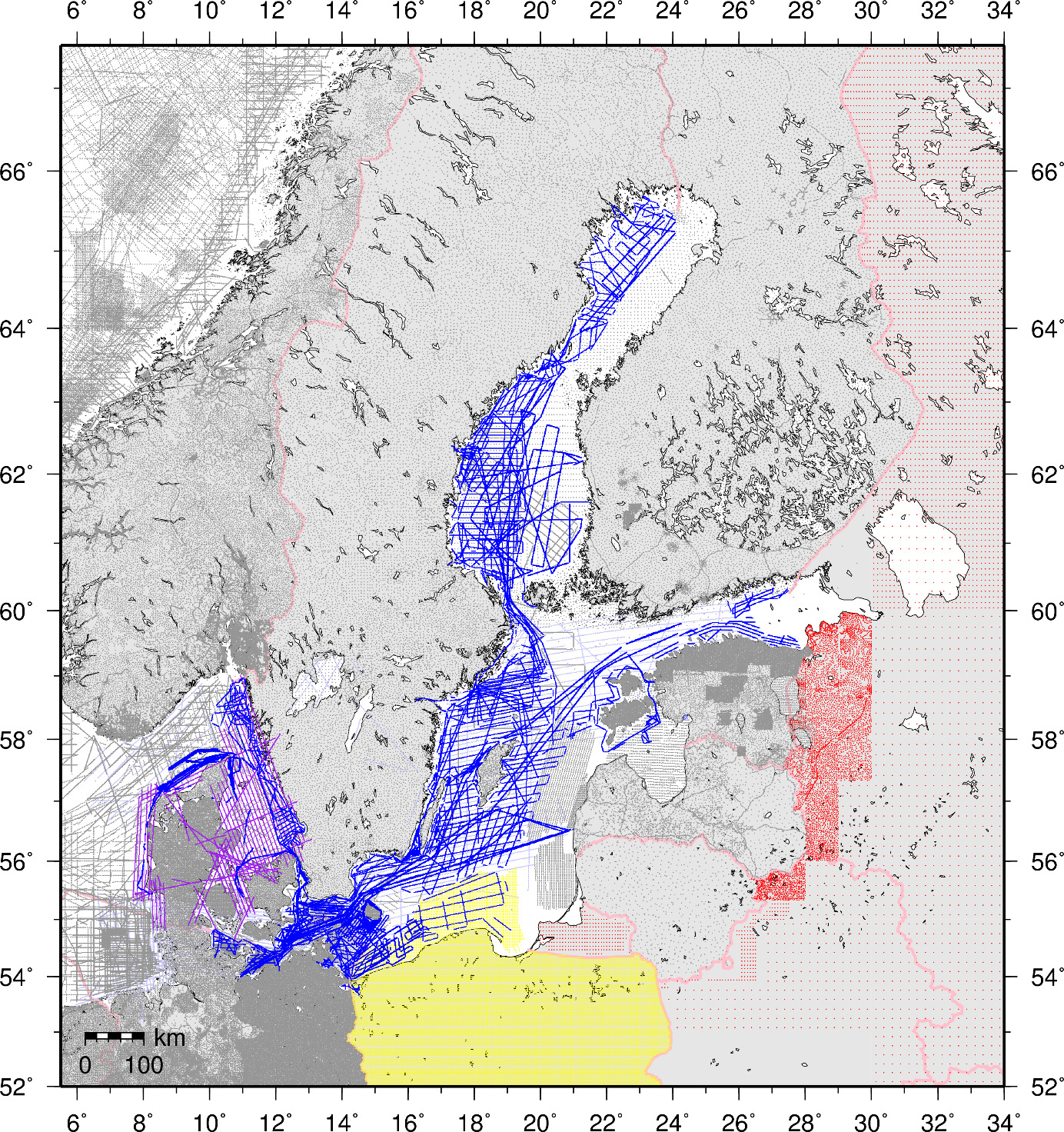
In most areas of the Baltic Sea, the available data now fulfills the requirements (in terms of accuracy and data density) to compute a geoid model according to the BSCD2000 specifications (see Section 2). The most significant areas void of reliable data remain over Russia, in particular close to St. Petersburg and Vyborg (Fig. 1). Further work is ongoing in the southeast part of the Baltic Sea (Poland and the Baltic countries) within the project BalMarGrav, co-funded by the EU under the Interreg Baltic Sea Region 2021/27 Programme (Grant no. #S009)1.
On the afore-described basis, the first BSCD2000 height transformation grid has been computed and is now ready for release.
2 Preparation of the BSCD2000 height transformation grid
This summary only addresses the general outline of the geoid computation and shall provide an impression of the results and the accuracy of the BSCD2000 height transformation grid. A technical description of the procedure and detailed analysis has been compiled in an internal report; a scientific publication is planned.
The process to derive the BSCD2000 height transformation grid was divided into two main phases. In the first phase, gravimetric quasigeoid2 solutions were computed by different computation centers. In the second phase, the transformation grid was constructed by merging and fitting the gravimetric solutions to the national height reference realizations according to the BSCD2000 specifications. The fitting procedure is based on the datasets of geodetic land surveying (GNSS heights and leveling at selected benchmarks), which also allows for an independent validation and accuracy assessment of the gravimetric quasigeoid solutions.
2.1 Gravimetric quasigeoid solutions
Four analysis centers participated in the final computations for this first release:
- Lantmäteriet, Sweden (LM): J. Ågren
- Federal Agency for Cartography and Geodesy, Germany (BKG): J. Schwabe, G. Liebsch
- Tallinn University of Technology/TalTech, Estonia (TUT): S. Varbla, A. Ellmann
- Technical University of Denmark – National Space Institute (DTU Space), Denmark (DTU): H. Teitsson, R. Forsberg
A redundant computation is another necessary means of quality control. Potential errors in a single solution or the data can be detected and analyzed. Different methods, background models, and software implementations contribute to double-checked results and provide empirical accuracy estimates describing the analyst noise.
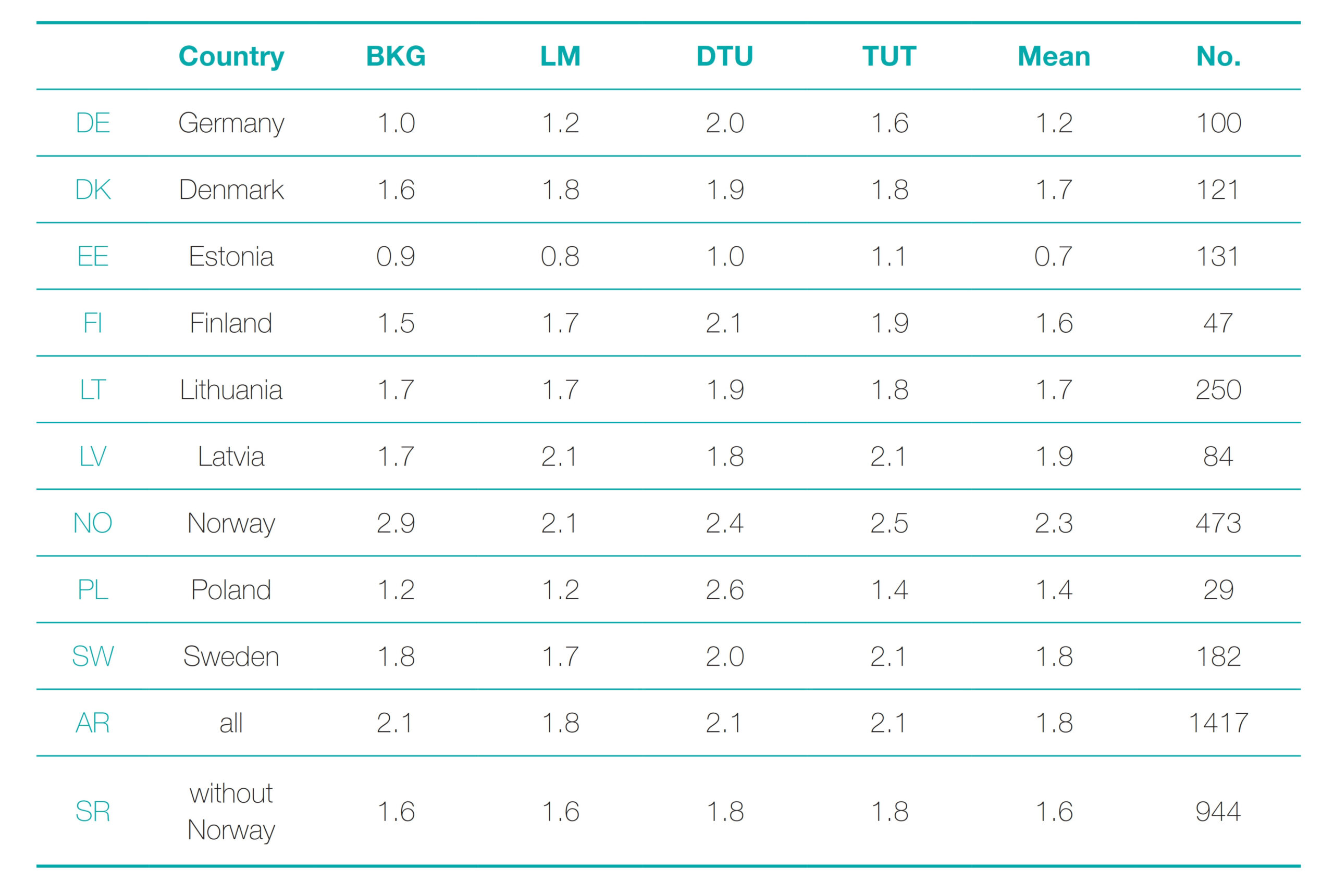
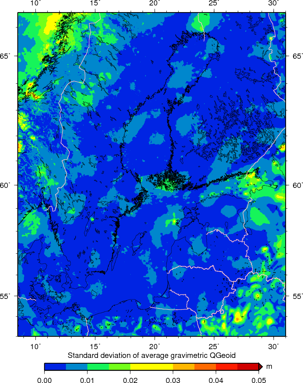
Table 2 shows the main validation results, i.e., standard deviations of residuals between the gravimetric quasigeoid solutions and the respective GNSS/ leveling data. The solutions of all analysis centers feature an equally high accuracy of about 2 cm (at most 3 cm) in terms of standard deviation for all models and all countries. This consistency implies that the models perform practically equally in all regions. At the same time, intra-model comparisons indicate a similar level of agreement for the ensemble mean (Fig. 2). This measure keeps below 1 cm in most areas of the Baltic Sea, whereas 2 cm occur only very locally. Due to the data gap, the models deviate stronger in the Russian part of the Gulf of Finland (ca. 3 cm close to Vyborg behind the Finnish border).
Thus, the formal compliance of the gravimetric quasigeoid model with accuracy requirements following the BSCD2000 specifications (5 cm standard uncertainty) is confirmed. An exception is a very localized part of Russia, which is currently not cooperating regarding the BSCD2000. The primary reason for the more significant uncertainties there is due to missing gravity data. Also, the models cannot be independently validated in these areas because GNSS/ leveling data are unavailable for Russia. On the other hand, this contrasting uncertainty demonstrates the benefit of the new marine gravity data collected in other areas, e.g., within the FAMOS project, allowing consistent modeling of the quasigeoid.
2.2 Computation of the BSCD2000 height transformation grid
The principal steps to construct the seamless and harmonized BSCD2000 height transformation grid are as follows:
- Merge the gravimetric quasigeoid solutions of the four analysis centers into one master solution.
Here, it was decided to apply a pointwise weighted mean based on the statistics in Table 2. Note that this gravimetric quasigeoid model does not yet refer to BSCD2000 but to a global zero level as defined by the potential of the Geodetic Reference System 1980 (GRS80; Moritz, 1980). - Compute a corrector surface by least-squares interpolation to fit the gravimetric quasigeoid model to the national geodetic references.
This procedure accounts for minor regionally correlated differences between the gravimetric quasigeoid model and the national geodetic reference frames around a few centimeters. The resulting model represents the offshore areas in the BSCD2000 quasigeoid grid. - Blend with the official national (quasi)geoid models on land by appropriate tapering.
The geoid model after step 2 still contains differences relative to the national geoid models (typically 1–3 cm) along the coast and on the mainland due to different input data, modeling areas, and methods. A blending with the national models was conducted to avoid discontinuities in the BSCD2000 grid. The national models were first merged using a transition zone (cosine taper) of 10 km to both sides of the national land and sea borders. This intermediate grid was then merged with the result of step 2. To this end, the transition window (10 km cosine taper) was defined seaward from the coastline.
The fitting and blending procedures ensure compatibility of the BSCD2000 height transformation grid with the national height reference frames from the land surveying so that no differences occur along the coast (apart from interpolation effects and minor adjustments at the national land borders). Such seamless transitions are essential for practical applications in the near-coastal areas.
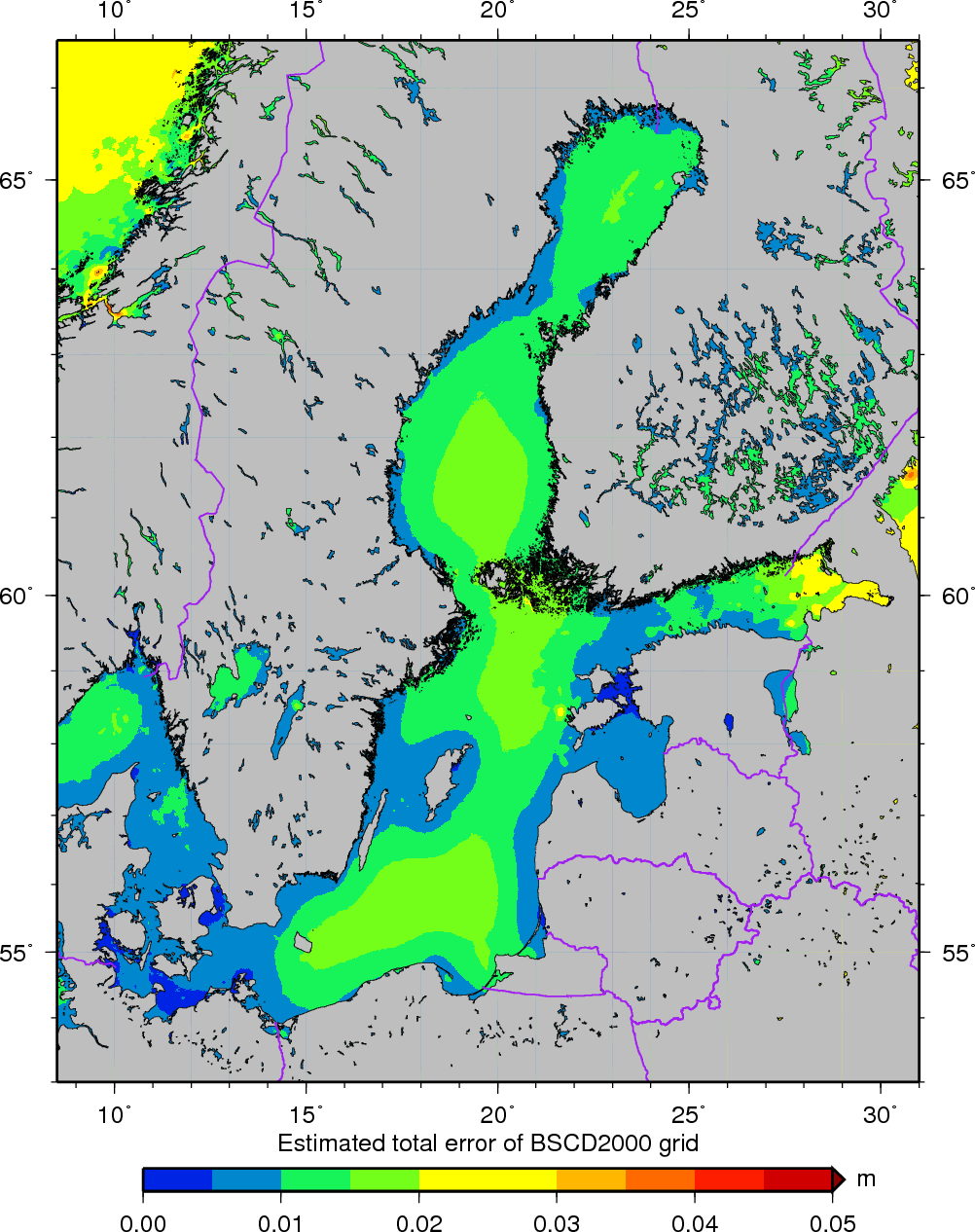
A combined error estimate of the BSCD2000 model, consisting of the standard deviation of the mean gravimetric quasigeoid model and the prediction error of the corrector surface, is presented in Fig. 3. Again, the typical accuracy is 1–2 cm.
3 Conclusions and further roadmap
The computations for the first release of the BSCD2000 height transformation grid have been finalized. It has been agreed on in the group of geodetic representatives of each country, except Russia (i.e., former FAMOS consortium), and acknowledged by the Baltic Sea Hydrographic Commission on the recommendation of the Chart Datum, Water Level and Currents Working Group (CDWCWG) to be adopted as the height reference surface for hydrography and navigation in the Baltic Sea. It is available for download from the BSCD2000 website via https://doi.org/10.58440/iho-bscd2000.
The results of the different analysis centers confirm the expected high level of accuracy. The mean gravimetric quasigeoid model from four different solutions and independent GNSS/leveling data agree at the level of 1–2 cm in terms of standard deviation. Exceptions occur only outside the current implementation area of the BSCD2000 (Russia and Norway).
The seamless BSCD2000 height transformation grid is harmonized with the current national geodetic realizations of coordinates and heights according to the BSCD2000 specifications (Ågren et al., 2023). This means that it is fitted to GNSS/leveling benchmarks and coincides with the national geoid models on land and at the coastline, except for minor effects at the cm level due to resampling effects between grids and discrepancies in the transition zones along national borders.
The merged gravimetric quasigeoid model shall be published as a by-product for scientific applications in geodesy and ocean modeling. These include, e.g., the International Height Reference Frame (IHRF), the European Height Reference Surface (EHRS), or a combination with altimetry to compute an improved geodetic model of the mean dynamic ocean topography of the Baltic Sea.
Data attribution
Information for GNSS/leveling data of Poland is hosted at the ASG-EUPOS reference stations website: https://www.asgeupos.pl/index.php?wpg_type=syst_descr&sub=ref_st (accessed 11 Oct. 2023).
The national geoid model for Poland PL-geoid-2021 (© GUGiK) is available as open data under license CC-BY 4.0 via the following websites (accessed 11 Oct. 2023): http://www.gugik.gov. pl/bip/prawo/modele-danych, https://www.isgeoid.polimi.it/Geoid/Europe/Poland/Poland_2021.html
All other datasets were provided actively by the co-authors or used under license.
References
Ågren, J., G., Liebsch and J. Mononen (2023). Specification of the Baltic Sea Chart Datum 2000 (BSCD2000). Version 5c, 2023-03-28. https://www.bshc.pro/wp-content/uploads/CDW- CWG_Specification-of-the-Baltic-Sea-Chart-Datum-2000.pdf (accessed 27 Sept. 2023).
CDWG8 (2016). Final Minutes of the BSCD CDWG8 Meeting on 23–24 February 2016. 19 April 2016. https://www.bshc.pro/wp-content/uploads/CDWG8_Minutes.pdf (accessed 17 March 2023).
EUREF (1990). Resolution No. 1. EUREF Symposium, Florence, 28–31 May 1990. http://www.euref.eu/html/resolutions_flor- ence1990.pdf (accessed 17 March 2023).
Flury, J. and Rummel, R. (2009). On the geoid-quasigeoid separation in mountain areas. Journal of Geodesy, 83(9), 928–847, https://doi.org/10.1007/s00190-009-0302-9
Häkli, P., Lidberg, M., Jivall, L., Nørbech, T., Tangen, O., Weber, M., Pihlak, P., Aleksejenko, I. and Paršeliūnas, E. (2016). The NKG2008 GPS campaign – final transformation results and a new common nordic reference frame. Journal of Geodetic Science, 6(1), 1–33, https://doi.org/10.1515/jogs-2016-0001
Ihde, J., Mäkinen, J. and Sacher, M. (2007). Conventions for the Definition and Realization of a European Vertical Reference System (EVRS) – EVRS Conventions 2007. https://evrs.bkg.bund. de/SharedDocs/Downloads/EVRS/EN/Publications/EVRFConventions2007.pdf (accessed 17 March 2023).
Liebsch, G., Schwabe, J., Westfeld, P. and Förste, C. (2022). Improving the geodetic infrastructure for bathymetry and 3D navigation in the German exclusive economic zone of the North and Baltic Sea. The International Hydrographic Review, 28, 121–138. https://doi.org/10.58440/ihr-28-a17
Moritz, H. (1980). Geodetic reference system 1980. Bulletin géodésique, 54(3), 395–405. https://doi.org/10.1007/ BF02521480
Sacher, M. and Liebsch G. (2019). EVRF2019 final report. https:// evrs.bkg.bund.de/SharedDocs/Downloads/EVRS/EN/Publications/EVRF2019_FinalReport.pdf (accessed 17 March 2023).
Schwabe, J., Horwath, M. and Scheinert, M. (2017). The evaluation of the geoid-quasigeoid separation and consequences for its implementation. Acta Geodaetica et Geophysica, 51(3), 451–466. https://doi.org/10.1007/s40328-015-0136-2
Schwabe, J., Liebsch, G., Ågren, J., Mononen, J., Andersen, O., Westfeld, P. and Hammarklint, T. (2020). The Baltic Sea Chart Datum 2000 (BSCD2000) – Implementation of a common reference level in the Baltic Sea. The International Hydrographic Review, 23, 63–83.
Sjöberg, L. E. (2010). A strict formula for geoid-to-quasigeoid separation. Journal of Geodesy, 84(11), 699–702. https://doi. org/10.1007/s00190-010-0407-1
- https://interreg-baltic.eu/project/balmargrav/ (accessed 2 Oct. 2023).
- The conceptual difference between the geoid and quasigeoid is a geodetic detail, which is only relevant on land at higher altitudes (e.g., Flury & Rummel, 2009; Sjöberg, 2010; Schwabe et al. 2017). Therefore, the terms can be used synonymously for marine applications.