
Abstract
1 The rise of global momentum for an integrated marine geospatial information management
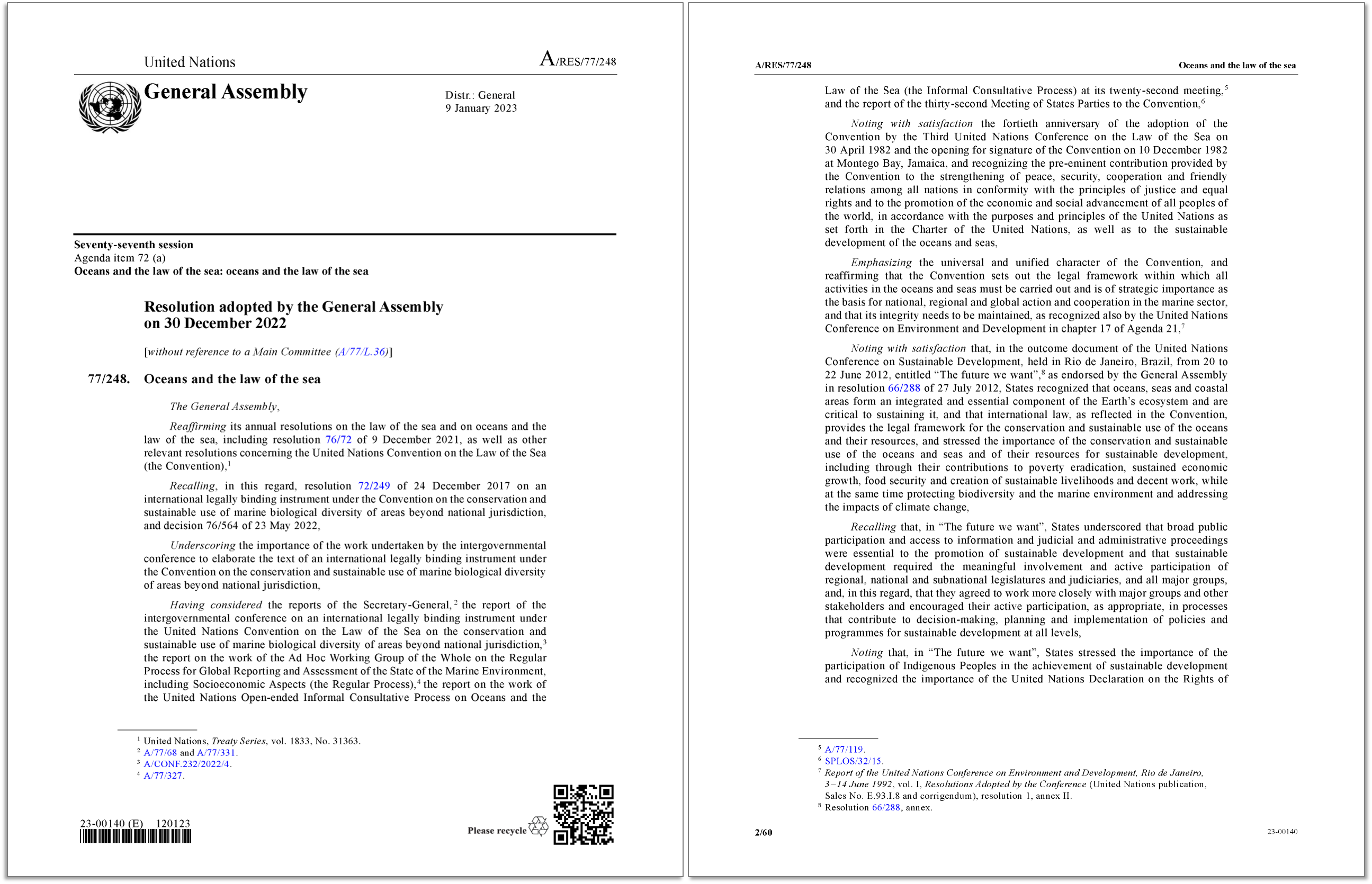
On 30 December 2022, the General Assembly of the United Nations (UNGA) adopted its annual Resolution on Oceans and the Law of the Sea1 (Fig. 1). Familiarly referred to as the “omnibus resolution” by national delegates and the officers of the Secretariat responsible for providing services to the relevant global consultations, this instrument indeed lists all legal, policy, and institutional developments concerning the oceans, identifies the priority areas of implementation and cooperation in the marine sector for United Nations Member States and other relevant subjects, and provides instructions to the United Nations Secretariat regarding specific tasks related to these matters2. Adopted by the principal representative organ of the Organization, it is the main policy instrument at the global level addressing the wide spectrum of the extraordinarily diverse legal, political, and economic factors covered by the law of the sea. A substantial number of both the preambular and operative paragraphs of the UNGA omnibus resolution refer to the United Nations Convention on the Law of the Sea (Montego Bay, 1982; UNCLOS)3 and related implementing instruments4. The legal regime embodied in the UNCLOS addresses a variety of aspects of the relationship between humankind and the oceans, which include also quite a few technical ones (Proelss, 2017). Among the latter, prominent is the definition of the extent of marine spaces, including the delineation on charts of the respective baselines and outer limits (Beazley, 1987; Carleton & Schofield, 2001; Prescott & Schofield 2005), as well as the settlement of States boundaries vis-à-vis opposite or adjacent States (Lando, 2019; Tanaka, 2019), as the present contribution shortly will discuss.
Being the depositary of the UNCLOS and its implementing agreements, the Secretary-General of the United Nations performs the secretariat functions related to these instruments. It does so through the Division for Ocean Affairs and the Law of the Sea (DOALOS; Tani & Tarassenko, 2012). The latter is a specialized unit integrated into the Office of Legal Affairs (OLA) of the United Nations Secretariat that, in addition to depositary functions on behalf of the Secretary-General, discharges specific functions with respect to charts and lists of geographical coordinates of points concerning marine spaces, including lines of delimitation, which are to be given due publicity by States through their deposit with the Secretary-General (Symmons & Reed, 2010). Notably, further functions performed by DOALOS include the publication of analytical and informative studies.
These past few years have marked the beginning of a revived surge of interest worldwide for the topic of marine geospatial information management, which is reflected in the work of the International Hydrographic Organization (IHO) and United Nations relevant bodies. To achieve an integrated management and move from local to global, a continuous interdisciplinary exchange is crucial, aimed at understanding the methods of acquisition, management, use, and purposes of data, as well as identifying and coordinating the data-holding entities around the world in the legal, economic, environmental, pure research, and applied research sectors. The necessity of mutual comprehension among different sectors also constitutes the rationale behind the author’s proposal of a contribution of juridical content to a highly specialized journal that has been publishing in hydrography for a century, with the hope that an effective discourse can be fostered in this forum as we move towards a new way of managing information related to marine geospatial data.
Building on this momentum, the present contribution will firstly introduce an initiative launched in the latest UNGA omnibus resolution, which, in paragraph 388, requested the Secretary-General to prepare “a publication on marine geospatial information management”. This publication, scheduled for completion by the end of the year, will be largely based on contributions submitted by States and international governmental organizations.
Secondly, this contribution will address the significance of marine geospatial data in the law of the sea. Inter alia, the management of geospatial data in the realm of maritime limits and boundaries, governed by specific – but still developing – rules under the law of the sea, stands as an instance of a necessarily interdisciplinary domain. In this context, cartographic expertise must align with legal competence, ensuring the accurate interpretation and dissemination of information to all relevant stakeholders.
Finally, this contribution will aim at emphasizing the role of hydrographic offices in the challenge of moving from local to global in the management of marine geospatial information, focusing on the experience of the national service of a State that is a Member of the IHO and relevant United Nations working groups and processes.
2 The forthcoming publication of the Secretary-General of the United Nations on marine geospatial information management
Following the UNGA request, on 6 January 2023 DOALOS sent out letters inviting Member States and international governmental organizations to nominate, by 10 February 2023, experts in the field of marine geospatial information management, with a view to establishing a Group of Experts to assist the Secretary-General in preparing the mentioned publication.
The request of the General Assembly through DOALOS offered to Member States and relevant international governmental organizations the opportunity to report to the world on the activities related to the collection, storage, analysis, and dissemination of marine geospatial information, highlighting success stories, as well as relevant major obstacles. Such an exercise aims at building an integrated global marine geospatial data system that would help decision-makers understand the state of the marine environment better and develop informed policies, legislation, implementation strategies, and standards, with a view to improving the health and our knowledge of the oceans. It also represents an opportunity to highlight the significance of sharing marine geospatial information on a full and open basis to enable an efficient, integrated, and fit-for-multi-purpose utilization of that information.
As a matter of fact, marine geospatial information management is a broad topic. A wide range of data types related to an assorted diversity of ocean parameters (not just of hydrographic nature) are acquired and owned by different public organizations, research institutions, as well as private entities, and regulated by different authorities. Accordingly, DOALOS expressed awareness of the need to approach the task in a selective manner, focusing on aspects that States identified as priorities. In this regard, early inputs from Member States and relevant international governmental organizations were requested, by the end of May this year, in relation to their preferences as to the focus of the publication.
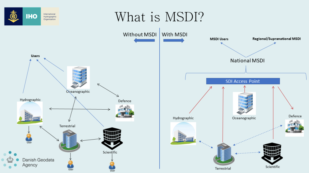
The questions that the United Nations Member States considered before requesting the Secretary-General to work on the publication included the main challenges facing the so-called marine spatial data infrastructures (MSDIs), meeting expanding societal demands, and integrating new technologies and capabilities. This includes reducing critical gaps, understanding specific cross-sectoral interrelations between different ocean parameters, and expanding our capability to measure and utilize more marine data. Another consideration is that MSDIs are a critical component of informed, science-based decision-making, and benefit from global coordination (Fig. 2). In sum, the publication will review the challenges of global marine geospatial information management and likely increase awareness on the importance of establishing MSDIs, particularly with respect to managing conflicting uses of marine areas, responding to emergencies, and improving coordination across international organizations and processes.
The Group of Experts for assisting the Secretary-General in preparing the publication was ultimately constituted, guided by the principle of equitable geographical distribution among the regional groups of the United Nations Member States. Ideally, the Group would have counted five experts from African States, three experts from Asia-Pacific States, and four experts from Eastern European States, Latin American and Caribbean States, and Western European and other States, respectively5. Based on the nominations received, the actual Group of Experts has counted three experts from Africa (Burundi, Kenya, Mauritius); three experts from Latin America (Argentina, Chile, Ecuador); two experts from Eastern Europe (Poland, Russian Federation); four experts from Western Europe and other States (Australia, France, Germany, Greece); and no expert from Asia and the Pacific. In the latter regard, however, it is noteworthy that the Group also included a representative of the Pacific Community, together with experts from the Department of Economic and Social Affairs (DESA) of the United Nations, the Food and Agriculture Organization (FAO) of the United Nations, the IHO, the International Seabed Authority (ISA), and the Secretariat of the Convention for the Protection of the Marine Environment of the North-East Atlantic (OSPAR)6. The six appointments resulted from nominations of the respective international governmental organizations who responded to the global call for participation. The Group of Experts held its first meeting online on 15 March and continued throughout meetings held fortnightly.
Concerning the focus of the publication, France, Ecuador, Egypt, the European Union, the Netherlands, Nigeria, Oman, Poland, and the United States of America, as well as the FAO and the Secretariat of the Convention on Biological Diversity (CBD), provided inputs within the relevant deadline. The Group of Experts thus prepared a list of topics and sections to be covered in the publication, taking into consideration such inputs.
The first draft table of contents of the publication was circulated in late June this year7, comprising four substantial sections concerning the (1) challenges of moving from local to global in the management of marine geospatial data, (2) the role of international governmental organizations, (3) the management of restrictions on data access, and (4) considerations on the steps forward. Notably, three annexes will cover (I) success stories at the national and regional levels, (II) the relevant intergovernmental organizations, and (III) data topics as per the Second World Ocean Assessment. The first annex will be based on inputs that DOALOS suggested its recipients to structure by highlighting the following: the geographic scope of interest and other key information about the initiative; the legislative, administrative, and policy frameworks mandating the marine geospatial information collection, coordination, standardization management, and dissemination activities; the institutional arrangement, including the governance model; relevant information on marine geospatial data, including data themes, acquisition, management, curation, and delivery; and marine geospatial information management technology and standards implemented (or under development), aiming at legal, data, semantic, and technical interoperability, as well as the geospatial information system description.
Member States and international governmental organizations were ultimately invited to provide comments on the proposed list of topics and sections, including annexes, drafted on the basis of the previous inputs, by 14 July. Inputs with respect to the third annex to the publication, under the above-mentioned proposed structure, were expected by 28 July.
It is worth observing that, in initiatives of this nature, experts’ participation holds paramount importance. Requests for inputs and calls for nominations to form Groups of Experts and similar bodies must expeditiously reach national administrations through the Permanent Missions of the Member States, which receive communications from the Secretariat. Without an efficient communication between Permanent Missions, national administrations, and pertinent stakeholders and experts within each State, the attainment of a uniform participation of Member States in shaping relevant documents, intended to reflect the experiences and needs of the broadest representation of States at the United Nations, remains uncertain. Unfortunately, instances are not uncommon where an inefficient management of the mail originating from the Secretariat, stalling at the Permanent Missions or national administrations, has hindered the assurance of such comprehensive participation. Yet, if notified appropriately, national-level practitioners and experts in the field would be the first to seek benefit from information exchange and contribute to the structure and contents of a document destined for such wide dissemination through the Secretariat.
The Group of Experts committed to complete its work by September this year. DOALOS will then finalize the publication with a view to submitting it for processing by the end of the year and possibly having it acknowledged by the forthcoming UNGA omnibus resolution.
3 The relevance of geospatial data information in the law of the sea
Marine geospatial data comprise information describing objects (e.g., a vessel, a fish stock, an underwater pipeline), events (e.g., a storm) or other features (e.g., underwater natural features, such as oceanic ridges or hydrothermal vents) located on the seabed or subsoil, within the water column, or on the marine surface (or in proximity to it, if it pertains to data related to the airspace above the sea). Typically, these data combine location information (usually in the form of geographical coordinates of points) with attribute information (the characteristics of the object, event, or phenomenon in question) and temporal information (the time or duration of the existence of the location and characteristics). The provided location can be either static in the short term (e.g., the location of an underwater infrastructure or a natural resource, such as a coral reef or a gas reservoir) or dynamic (e.g., shipwrecked persons in need of rescue, a polluting event caused by oil spill dispersion at sea, an expanding submarine seismic event).
The above-mentioned data encompass extensive spatial datasets gathered from various diverse sources, in various formats, which may include information such as census data, satellite imagery, hydrographic data, meteorological data, data from private entities, hand-drawn charts, data derived from specific events occurring over a short timeframe, and so on. All such data are most valuable when they can be collected, shared, analyzed, and used in conjunction with one another.
When temporal and spatial dimensions are added to traditional types of marine data, it becomes possible to create visualizations of such data. In the marine sector, these visualizations typically include maps of limits and boundaries, bathymetric charts to ensure safe navigation, graphs and statistics about the state of the sea and its resources, cartograms that display chronological and current environmental changes. This additional context provides a more comprehensive view of the relevant events. Insights that might be missed when reading a list of geographical coordinates of points or a massive spreadsheet are highlighted in easily recognizable nautical charts and other visual representations. This allows a faster and more accessible understanding – and often a more accurate forecasting.
For marine geospatial data to be comprehensible to a broad audience of operators, stakeholders, and managers, a fundamental step is provided by Geospatial Information Systems (GISs), which involve the physical mapping of data within a visual representation8.
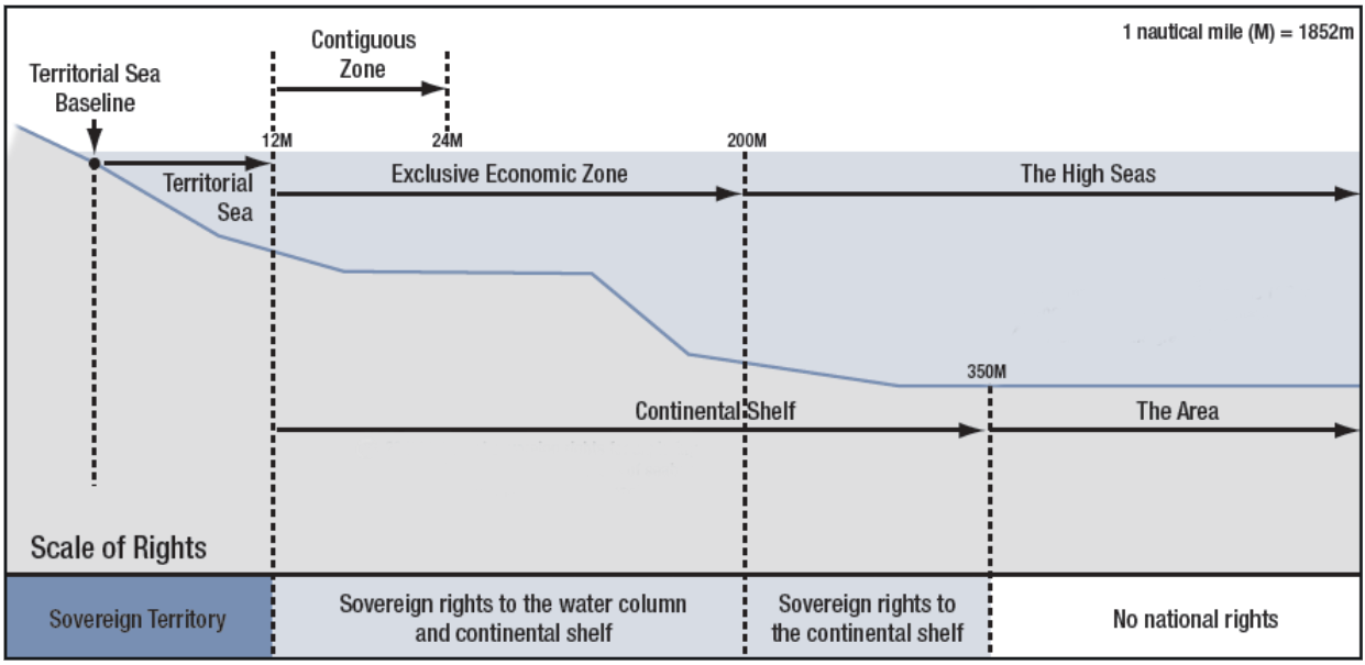
In the law of the sea, GISs prove crucial. Jurists are not familiar with the analysis and interpretation of geospatial data information without its visual representation. To begin with, such information is essential for locating the baseline from which the breadth of the territorial sea is measured, in accordance with the UNCLOS (Beazley, 1971; Prescott, 1985; Schofield, 2012; Lathrop et al., 2019). Being the line from which all the typical geometric constructions of the law of marine spaces originate, this line can be regarded as the foundational geospatial information in this realm of international law (Scovazzi, 1986)9. Marine geospatial data information is also at the basis of the definition of all marine spaces (Fig. 3) and the regulation of a range of diverse activities carried out at sea and regulated by the UNCLOS, including, but not limited to:
- the identification of sea lanes and traffic separation schemes in the territorial sea (Article 22 UNCLOS) and in straits used for international navigation (Article 41 UNCLOS);
- the identification of sea lanes and air routes in and above the archipelagic waters (Article 53 UNCLOS);
- the identification of specified areas of the territorial sea (Article 25, para. 3, UNCLOS) and archipelagic waters (Article 52, para. 2, UNCLOS) where the innocent passage of foreign ships may be temporarily suspended;
- the delineation of the course of submarine pipelines (Article 79, para. 3, UNCLOS)10;
- the construction of artificial islands, installations and structures (Articles 60 and 80 UNCLOS);
- the identification of living resources, such as commercially exploitable fish stocks (Articles 61 and 62 UNCLOS; and Part VII, Section 2, UNCLOS), and the patterns followed by highly migratory species (Article 64 UNCLOS), shared and straddling stocks (Article 63 UNCLOS), marine mammals (Articles 65 and 120 UNCLOS), anadromous stocks (Article 66 UNCLOS) and catadromous species (Article 67 UNCLOS), as well as sedentary species (Article 77, para. 4, UNCLOS), for the various purposes of conservation, utilization, or protection enshrined in the UNCLOS and specifically relevant legal instruments11;
- the identification of non-living resources, such as oil, gas, and other mineral resources (Articles 2, 56 and 77 UNCLOS for mineral resources to be found under national jurisdiction; Part XI UNCLOS and the relevant implementing agreement for the resources of the Area12);
- the filing of reports on violations (e.g., Articles 33, para. 1, b; 94, para. 6; 110; 111; 113; and 114 UNCLOS) or other publicly relevant events occurred at sea (e.g., Article 98 UNCLOS);
- the conduct of environmental impact assessments and activities related to the prevention, reduction, and control of pollution of the marine environment13;
- the establishment of marine protected areas (MPAs) and other effective area-based conservation measures (OECMs)14; and
- the undertaking of marine scientific research15.
According to another important and widely participated legally binding instrument, the International Convention for the Safety of Life at Sea (SOLAS; London, 1974; as amended several times), States Parties are required to arrange for the collection and compilation of hydrographic data and the publication, dissemination, and updating of all nautical information necessary for the safety of navigation (Chapter V, Regulation 9, SOLAS). Such instrument clarifies that hydrographic services include hydrographic surveying; the publication of, inter alia, nautical charts, sailing directions, lists of lights, and tide tables; the promulgation of notices to mariners to keep charts up to date; and the provision of data management arrangements to support these services. With the view to ensuring the greatest possible uniformity in charts and nautical publications, States Parties shall take into account the relevant international resolutions and recommendations (namely, those adopted by the IHO). In this sector, as also recognized by the SOLAS, coordination is key, in a manner that hydrographic and nautical information is made available on a world-wide scale as timely, reliably, and unambiguously as possible.
The items mentioned above are just a few examples that illustrate the relevance of marine geospatial data in the field of the law of the sea. It is noteworthy that the request made to the Secretary-General to prepare a publication on marine geospatial information management was outlined in a resolution of the General Assembly on oceans and the law of the sea, and the task has been entrusted to the Group of Experts assisted by GIS and legal professionals of DOALOS. As a matter of fact, technical and legal aspects intertwine substantially in this field. At least other two considerations can be made in this regard.
The first consideration lies in that a significant number of globally defined objectives that make use of geospatial data, such as the prevention, reduction, and control of marine pollution, the protection of a certain percentage of the oceans through the establishment of MPAs and OECMs16, actions to mitigate climate change that impacts sea-level rise, maritime spatial planning, sustainable fisheries, and the Blue Economy, are embedded in legal and policy instruments. These instruments, adopted at the international or regional levels, are in turn implemented through national legislation and regulations that necessarily make use of geospatial data. Moreover, the texts of geo-regulations and licenses, containing geographic coordinates, are necessarily drafted with the support of legal professionals.
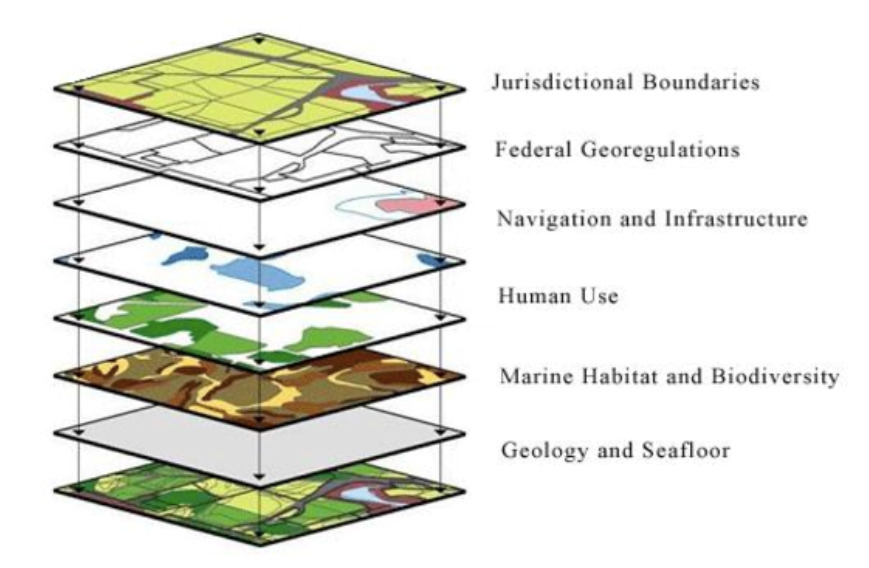
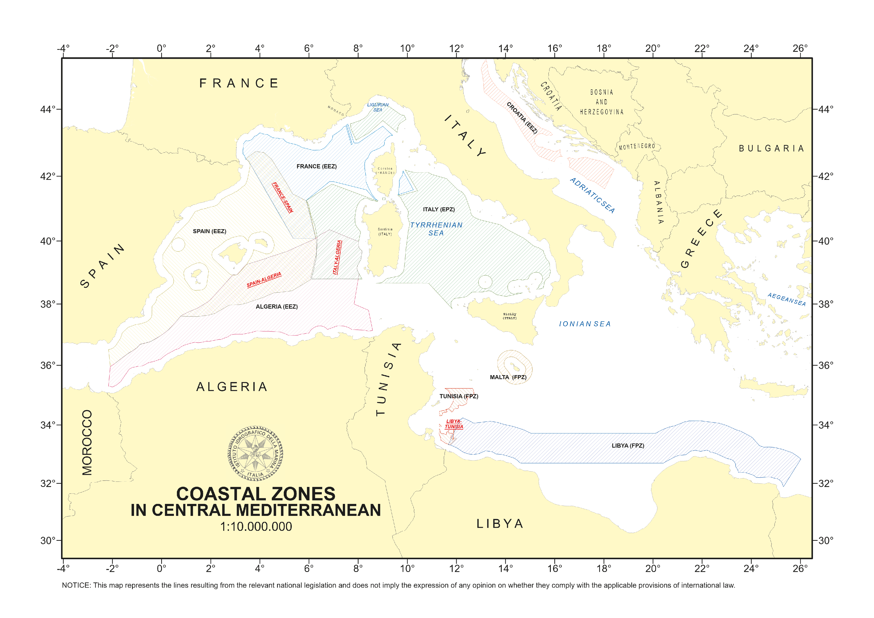
The second consideration lies in that data related to the legal limits and boundaries of maritime spaces represent, in comparison to all other types of geospatial data, the foundational layer upon which every other administrative, environmental, economic, social, and scientific consideration can be built (Fig. 4). For example, it is only by knowing the inner and outer limits of the territorial sea that one can determine the spatial extent of the right of innocent passage of foreign vessels (Tanaka, 2006; Vukas, 2007); it is only by knowing the submarine boundary between adjacent or opposite States that a legitimate licensing scheme for the exploitation of the resources of the continental shelf can be defined; it is only by knowing the boundary between adjacent or opposite exclusive economic zones that one can determine which State has jurisdiction over fishing licenses or permits for scientific research. In other words, none of these activities (in the mentioned examples: coastal navigation, continental shelf exploitation, fishing, scientific research) can set aside the definition of marine spaces according to the law of the sea (Tanaka, 2023). All these activities, in turn, use marine geospatial data (in the mentioned examples: geographic coordinates related to the position of ships or gas and oil blocks, moving patterns of fish stocks and position of fixed fishing gears, tracks of scientific survey). It is therefore evident that an initial interdisciplinary exercise towards an informed and efficient management of marine geospatial data is the one that intersects the work of technical experts in the hydrographic field with that of experts in the technical and substantive aspects of the law of the sea.
As a matter of fact, marine spaces are defined by a combination of legal and geospatial rules. The former rules define how lines representing maritime limits and boundaries should be drawn in order to comply with international law (as codified in the UNCLOS), while rules of geodesy and hydrography, combined with GIS and rules of cartography, allow to define those lines unambiguously and place them on charts, making it possible to visualize them in the actual marine space. Moreover, rules of cartography allow to illustrate on a plane surface spaces that are delimited on the curved shape of the Earth, controlling unavoidable deformations. Accordingly, the points mandated by legal rules and identified through geodetic methods and hydrographic analyses, the cartographic segments connecting those points, and the resulting geographic areas enclosed within those segments become the fundamental geometric elements through which the law of maritime limits and boundaries operates. Defining limits and boundaries at sea is a complex endeavor, which cannot be addressed by either international law or hydrography separately.
Examples are many of the necessary combination of competences in the management of geospatial information for what concerns the establishment of maritime limits and boundaries. With regard to the former, legal rules concerning the inner limits of marine spaces require hydrographic analyses for the identification of the low-water line along the coast, mandated as the “normal” baseline in Article 5 UNCLOS17, and a combination of methods adding geographical considerations and geometrical constructions is required in cases representing exceptions to the normal rule, as mandated per Article 7 UNCLOS for the construction of straight baselines18. Article 9 UNCLOS on straight baselines to be drawn across the mouth of rivers, Article 10 UNCLOS on the closing of juridical bays (Strohl, 1963; Westerman, 1987; Scovazzi, 1988), Article 13 UNCLOS on the identification of low-tide elevations (Tanaka, 2006), and Articles 46 and 47 UNCLOS on the criteria for claiming an archipelagic status and the construction of archipelagic baselines represent additional instances where legal considerations intertwine with scientific competences. For what concerns the identification of the external limits of marine spaces, it is noteworthy that while international law mandates a fixed, maximum distance for the majority of the coastal zones, namely, 12 nautical miles for the territorial sea (Article 3 UNCLOS), 24 nautical miles for the contiguous zone (Article 33 UNCLOS), and 200 nautical miles for the exclusive economic zone (Article 57 UNCLOS), it envisages the application of a very different method for the definition of the external limit of continental shelves extending beyond 200 nautical miles from the baselines19. One of the most outstanding instances of the necessary interdisciplinary exercise between lawyers of the sea and experts in hydrography, cartography, geology, geomorphology, and related disciplines is the display on a map of the external limits of the so-called outer continental shelf, based on submissions that are made by coastal States Parties to the UNCLOS to a technical body established by the latter, namely the Commission on the Limits of the Continental Shelf (CLCS). By confirming national jurisdiction over millions of square nautical miles of seafloor beyond 200 nautical miles, the recommendations of the CLCS20 open up immense opportunities for the coastal States involved and are constructed on the basis of marine geospatial data information that, obviously, become of outstanding economic importance (Kunoy, 2023). Such information includes the outermost fixed points at each of which the thickness of sedimentary rocks is at least 1 per cent of the shortest distance from such point to the foot of the continental slope (socalled Irish or Gardiner formula), or fixed points not more than 60 nautical miles from the foot of the continental slope (so-called Hedberg formula)21. In both cases, the fixed points defined by coordinates of latitude and longitude must be connected by straight lines not exceeding 60 nautical miles in length (Article 76 UNCLOS, para. 7). In neither case such lines shall exceed 350 nautical miles from the baselines from which the breadth of the territorial sea is measured or 100 nautical miles from the 2,500-meter isobath. Additional rules concern the diverse legal treatment of different underwater features, such as submarine ridges, on which the external limits of the outer shelf cannot exceed 350 miles, and submarine elevations that are natural components of the continental margin, such as its plateaux, rises, caps, banks, and spurs, which are not counted under this rule (Article 76 UNCLOS, para. 6)22 (Kunoy, 2020).
In addressing the management of geospatial data related to maritime limits, it is noteworthy that while systems of straight baselines and the external limits of the territorial sea, exclusive economic zone, and continental shelf fall under an obligation of due publicity by the coastal State, there are no similar provisions in the law of the sea for the contiguous zone – and this may entail problems of access to authoritative geospatial data information concerning the actual existence and extension of such zone.
It is only when adjacent or opposite coastal States cannot claim a full entitlement to their costal zones that the question of drawing maritime boundaries takes place. In this context, rules that have been developed for the determination of land boundaries – i.e., the effective exercise of State authority (so-called effectivités)23 (De Visscher, 1967) – are no longer applicable at sea and are replaced by completely different rules that are based on other considerations, mostly of geographical character24 (Bardonnet, 1976 and 1989).
This contribution does not aim to delve into the complexity of the issues raised by the limited legal rules and the diverse States’ and judicial practice regarding maritime delimitations (Lando, 2019; Tanaka, 2019). It is the hope of the author that these rules and case law, building on highly technical aspects of geospatial nature, may become the subject of future contributions in this forum. It suffices to say here that the preferential role attributed in this matter to geographical factors (compared to socio-economic or other factors) emphasizes the role of geospatial data information and the mastery of the geometric tools that enable the delineation of boundaries on maps (Pearcy, 1959; Fietta & Cleverly, 2016). In fact, in the case law of maritime delimitations, the application of rules is mostly inferred from geography (the actual shape and position of the coasts and the presence of other relevant features, such as islands) and is implemented by geometry (through the drawing of median or equidistance lines constructed on carefully selected basepoints and the subsequent implementation of relevant geometrical adjustments, as appropriate) (Antunes, 2003; Lando, 2019; Tanaka, 2019). The status of certain maritime features such as islands and rocks adds legal intricacies to the picture (Schofield, 2019 and 2021; Rothwell, 2022).
Hydrography plays a fundamental role also in making both maritime limits and boundaries known to all relevant stakeholders and the international community, i.e. in fulfilling the relevant due publicity obligation under international law (Reed, 2011). More specifically, Article 16 UNCLOS requires that any baseline of the territorial sea that differs from the normal baseline be shown on charts of a scale adequate to ascertain their position25. Alternatively, charts may be substituted by lists of geographical coordinates of points, specifying the geodetic datum26. The same requirement is provided for geospatial data information identifying archipelagic baselines (Article 47, para. 8, UNCLOS), the outer limit lines of the exclusive economic zone (Article 75 UNCLOS), and the outer limit lines of the continental shelf (Article 76, para. 9, UNCLOS). In addition, coastal (or archipelagic) States shall give due publicity to such charts or lists of geographical coordinates and shall deposit a copy of each such chart or list with the Secretary-General of the United Nations27. Notably, for the case of the outer limit lines of the continental shelf, the due publicity obligation entails the requirement to deposit the relevant geospatial data information not only with the Secretary-General of the United Nations, but also with the Secretary-General of the ISA (Article 84 UNCLOS, para. 2)28, for the evident reason that any extension of the continental shelf beyond 200 nautical miles from the baselines entails a corresponding deduction from the international seabed and ocean floor and subsoil thereof (the so-called Area), administered by the ISA on behalf of the States Parties to the UNCLOS29.
In this connection, it should be noted that the due publicity obligation is twofold, as it involves both the relevant State and the Secretary-General. The deposit with the latter of charts or lists of geographical coordinates is a unilateral international act by a State to comply with its due publicity obligation30. This act is addressed to the Secretary-General in the form of a note verbale or a letter by the permanent representative to the United Nations or other person considered as representing the State Party. The mere adoption of legislation or the conclusion of a boundary delimitation agreement registered with the Secretariat, even if they contain charts or lists of coordinates, cannot be interpreted as an act of deposit with the Secretary-General under the UNCLOS31. Notably, in any case, the lack of deposit does not compromise in any manner the validity of a national legislation defining maritime limits.
In turn, the Secretary-General is directly required under the UNCLOS to give due publicity to the relevant geospatial data information. In fact, upon request of the General Assembly, DOALOS has established, develops, and maintains the appropriate GIS and other facilities for the custody of charts and lists of geographical coordinates deposited and for the dissemination of such information, with a view to assisting States in complying with their due publicity obligations32. To this end, DOALOS acknowledges receipt of the deposit in a note verbale addressed to the Permanent Mission of the depositing State to the United Nations and promptly informs all Members States of the United Nations and all States Parties to the UNCLOS of the deposit through a “maritime zone notification”, circulated in English and French. These notifications are subsequently circulated to States through a global documentation management system (gDoc) and published in the Maritime Space: Legislation and Treaties Database on the website of DOALOS33 and in the Law of the Sea Bulletin34. Communications by other States in response to the deposited charts and lists are also published by DOALOS, but only upon explicit request of the responding State and, in this case, no notifications are issued35.
Following modern trends in the management of information that is geospatial in nature, as well as utilizing the internal human and software resources designated primarily to provide services to the CLCS, DOALOS has established a GIS entitled Maritime Limits and Boundaries Database. This database enables the office to store and process the deposits and produce custom-tailored cartographic outputs through the conversion of conventional maps, charts, and lists of geographical coordinates in digital format.
It also helps DOALOS identify any inconsistency of the information submitted. This database, which is connected to the public Maritime Space: Legislation and Treaties Database, facilitating retrieval of relevant legal texts, is still internal and venues are being explored to make it publicly available.
As with any database design and entering of data, DOALOS has been facing numerous issues of technical nature, most of which were initially associated with the absence of a coordinated and standardized approach by States in their description of maritime limits and boundaries. Among other problems, baselines were defined in different manners around the world; States often used their national horizontal datum to deposit geospatial information; States used different lines to connect basepoints; and deposits were made in different formats. Over the years, such lack of homogeneity in the collection, storage, and dissemination of geospatial information had become a source of concern to United Nations Member States, to the point that the General Assembly, in resolution 59/24 of 4 February 2005, requested the Secretary-General to implement, in cooperation with relevant international organizations, such as the IHO, technical standards to ensure compatibility among the GIS, electronic nautical charts, and other systems developed by these organizations36. The draft technical standards were eventually assigned the product specification’s identifier S-121 and titled Maritime Limits and Boundaries within the IHO S-100 product specifications’ framework (Beaupré et al. 2022). The S-121 edition 1.0.0 was released in October 2019 for implementation and testing purposes only, intended for the encoding and exchange of digital maritime boundary information including maritime limits and boundaries described by the UNCLOS37.
Through the omnibus resolution, the UNGA has repeatedly called upon States Parties to the UNCLOS that have not yet done so to deposit with the Secretary-General the marine geospatial data information required under the UNCLOS, “preferably using the generally accepted and most recent geodetic datums”38. The UNGA noted, in this regard, the ongoing efforts of the Secretary-General to improve the existing GIS for the deposit by States of charts and geographical coordinates concerning maritime zones, including lines of delimitation, submitted by States Parties to the UNCLOS, and to give due publicity thereto. It also noted the ongoing cooperation and progress achieved in the development by the IHO, in cooperation with DOALOS, of the technical standards (i.e., S-121) for the collection, storage, and dissemination of the information deposited. In 2022, the UNGA re-emphasized the importance of the completion of these efforts through wide participation and reviews by all United Nations Member States.
Legally speaking, a standard is not a binding document. It is rather defined as “a document, established by consensus and approved by a recognized body that provides for common and repeated use, rules, guidelines or characteristics for activities or their results, aimed at the achievement of the optimum degree of order in a given context”39. In the marine geospatial context, it is only through the standards specified in S-121 and related product specifications that such an “optimum degree of order” – i.e., compatibility among GISs, electronic nautical charts, and other systems – can be ensured. In this connection, also DOALOS provided important references and recommendations for the attention of States Parties to the UNCLOS, with a view to clarifying certain aspects of the obligations of deposit and the related functions of the Secretariat, as subsequently this contribution will discuss based on a practical exercise conducted in collaboration with a national hydrographic office.
4 Moving from local to global and from product-based to data-centric strategies: the role of hydrographic offices through a national success story
Some hydrographic offices have developed significant experience in collecting, managing, and disseminating marine geospatial information over a long period. As an exemplary case among the oldest services worldwide, the Italian Navy Hydrographic Office (Istituto Idrografico della Marina, IIM) was founded in 1872, hence celebrated its 150th anniversary last year. The IIM discharges responsibilities in the management of marine geospatial data by providing hydrographic services, i.e. maritime safety information, hydrographic, topographic and geodetic surveys, charts production and their constant updating, nautical publications, chart distribution arrangements, and training of hydrographic surveyors and nautical cartographers. These typical functions, pursued by hydrographic services worldwide, primarily focus on the safety of navigation. However, the use of hydrographic information could serve a broader range of other purposes in the legal, economic, social, environmental, and research sectors, including not only maritime limits and boundaries and the administration of spaces, as recalled above, but also maritime trade, environmental protection, sustainable fishing, resource development, infrastructure construction and maintenance, the protection of archaeological and historical objects found at sea, emergency management and response, law enforcement and defence, vessel and aircraft search and rescue, and submarine escape and rescue.
Long-standing services such as the IIM possess a fundamental expertise of the dynamics of the use of marine geospatial data and the possibilities that such data offer in terms of interoperability. Third-party private operators, such as those developing commercial applications, public authorities, as well as public and private research centers, use data provided by hydrographic services for various purposes, often merging them with other types of data. Also, non-authoritative data collected by third-party operators can eventually be validated and classified as trusted data through the intervention of the hydrographic authorities40. Hence, hydrographic services can be considered as the main marine geospatial data providers and custodians and be viewed as the competent authorities concerning the provision of authoritative hydrographic and other marine-related data. Their continuous exchange with third-party geospatial data management operators and their established expertise in the fields of surveys and marine geospatial products put the hydrographic services in the best position to develop MSDIs, support existing MSDI initiatives, or work with others to develop MSDIs, such as in the context of capacity-building activities. Hence, hydrographic services can provide the capabilities necessary to support the increasing demand for marine geospatial data. In simple terms, hydrographic services make marine data available.
Still, hydrographic services mostly collect data to create specific products, in standardized formats, such as nautical charts. These charts are built on bathymetric data and address the specific purpose of safe navigation. As such, specific products have a limited use and a narrow user base. However, the data collected to create these products – namely, bathymetric data – may serve a broader range of uses and involve a potentially larger user base. For instance, bathymetric data may serve the purposes of maritime spatial planning, submarine rescue and escape, tsunami modelling, infrastructure construction, etc. The same consideration could apply to a multitude of different types of marine geospatial information, such as oceanographic data, geological and geophysical data of the seabed and subsoil, marine biological and cryosphere data, meteorology and climate data, land-sea interface data. If such data continue to be tailored for specific products, both the use and user base will continue to be substantially constricted; instead, if data are placed at the center of a broader system and designed for re-use by a broader community of stakeholders, their value will remarkably increase. Hence, a shift should occur from a product-based approach to a data-centric approach. This would enable a more efficient, integrated, innovative, and fit-for-multi-purpose utilization of marine geospatial information. Considering that hydrographic services are the major source of that information, their role in this transition will be prominent.
Moreover, hydrographic offices are crucial contributors to the development of analytical studies on the management of marine geospatial information, such as the Secretary-General’s publication mandated by the General Assembly of the United Nations. In fact, besides holding authoritative and timely geospatial information, they represent an already established network that speaks the same language through international standards, which is a crucial feature for an integrated, data-centric, and fit-for-multi-purpose management of geospatial information. This network may function through bilateral or multilateral collaborations, and more effectively through memberships to the IHO and the United Nations relevant working groups.
In this regard, participation in the relevant institutional fora is a way to ensure, and benefit from, dialogue also with other marine geospatial data holders and users on an international scale, and so move from the local to the global context in addressing common concerns and sharing good practices. Active participation in international meetings dedicated to central aspects, such as improving data quality, expanding the user base, structuring data governance, and creating MSDIs, is crucial. Global coordination greatly benefits the establishment of MSDIs, which are a critical component of science-based decision-making.
The IIM participates in the relevant meetings of the United Nations Committee of Experts on Global Geospatial Information Management (UN-GGIM), operating under the auspices of the Economic and Social Council (ECOSOC) of the United Nations. UN-GGIM is the apex Member States-led policy and technical mechanism for making joint decisions and setting directions regarding the production, availability, and use of geospatial information. In February this year, the IIM hosted the Fourth Expert Meeting of the UN-GGIM Working Group on Marine Geospatial Information (the Working Group) in Genoa, Italy41. The Working Group aims to provide a forum for dialogue and coordination among Member States, and between Member States and the IHO, the United Nations system, and relevant international organizations, to enhance global cooperation, advocate, and improve the availability and accessibility of integrated marine geospatial information. Fifty participants, expert representatives from nineteen Member States, three international organizations, and three other academic and private sector entities met together over five days in a conducive setting and with a coordinated agenda that included the Fourteenth Meeting of the IHO Marine Spatial Data Infrastructures Working Group (IHO-MSDIWG) and a meeting of the Marine Domain Working Group of Open Geospatial Consortium (OGC-MDWG). Moreover, the IIM contributed to the drafting of IHO Publication C-17, Spatial Data Infrastructures “The Marine Dimension” – Guidance for Hydrographic Offices, Edition 3.0.0, currently under call for approval by the IHO Member States, to be issued in October 2023.
In August this year, the UN-GGIM endorsed the complete Operational Framework for Integrated Marine Geospatial Information Management (UNIGIF-Hydro), composed of Part One – The Strategic Overview42 (Fig. 5a) and Part Two – The Strategic Pathways43 (Fig. 5b). The complete framework had undergone consultations among the Member States, building on consensus, and the UN-GGIM encouraged the Working Group to practically support its Members to implement the nine strategic pathways at the national level44. In this regard, as noted by the Members of the European regional group at the Thirteenth Session of UN-GGIM, in which the IIM participated with its delegation45, it is critical to raise awareness among the Permanent Missions of the United Nations Member States about the importance of an effective dialogue between the Organization and national administrations responsible for managing marine geospatial data.
As previously illustrated, an informed management of marine geospatial data is the one that also intersects the work of technical experts in the hydrographic field with that of experts in the technical and substantive aspects of the law of the sea. A practical example may be found in an initiative that the author of this contribution pursued with the collaboration of the national hydrographic service. In 2020 the IIM issued – and constantly updates – an Atlas of Maritime Limits and Boundaries in Central Mediterranean: Legal Texts and Illustrative Maps (Tani et al., 2020; Figs. 6–8). This work shows the interrelations between two marine geospatial data-related disciplines, namely, cartography and law. Geospatial data are at the center of the system: the study of the relevant geographical area and the construction of geographical coordinates of points of the maritime limits and boundaries of States based on legal rules represent a common endeavor of cartographers, hydrographers, geographers, as well as legal professionals including lawyers, legal advisers, negotiators, judges, arbitrators, public administrators, and legislators. Geographical coordinates of points that are listed in national legislations, bilateral maritime boundary agreements between opposite or adjacent States, or decisions of international courts or tribunals settling a maritime boundary dispute identify lines at sea that become the foundational “grid” or “layer” for any other spatial construction regulating the use of maritime spaces (navigation, fishing, construction of artificial islands, installations and structures, resource development of the seabed and subsoil, marine scientific research). Such common endeavor moves from local to global as it takes more than one State into account in the construction of international boundaries and is aimed at being expanded to include other regions, moving to a global approach.
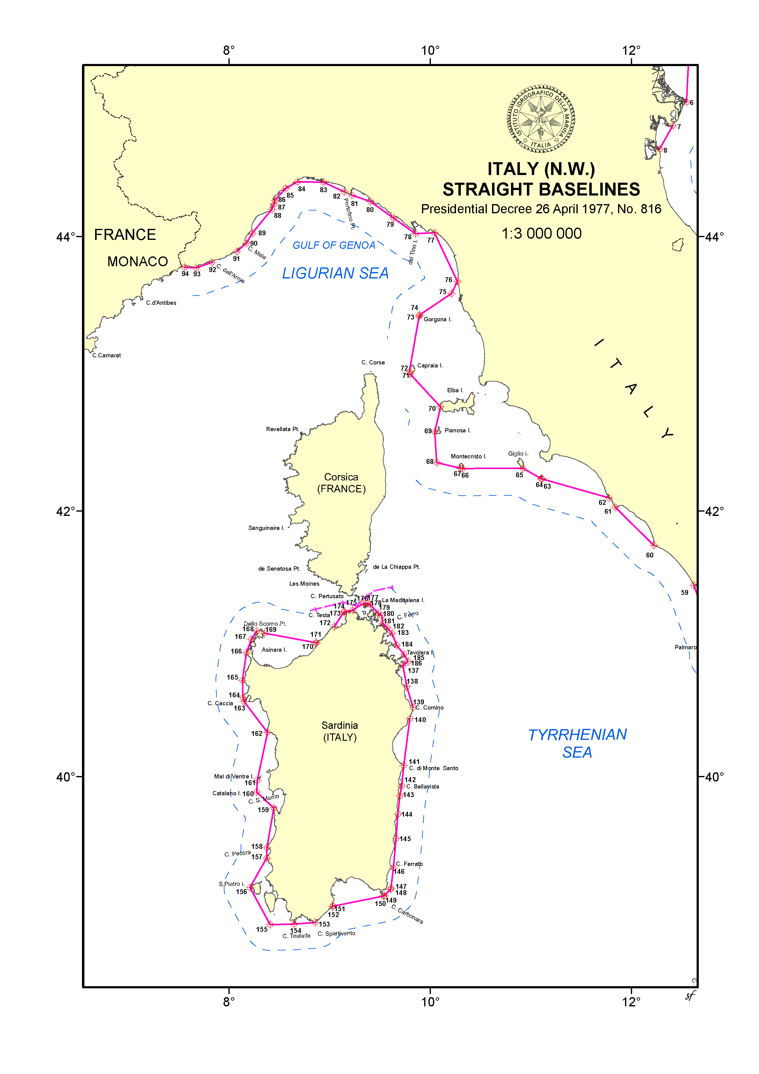
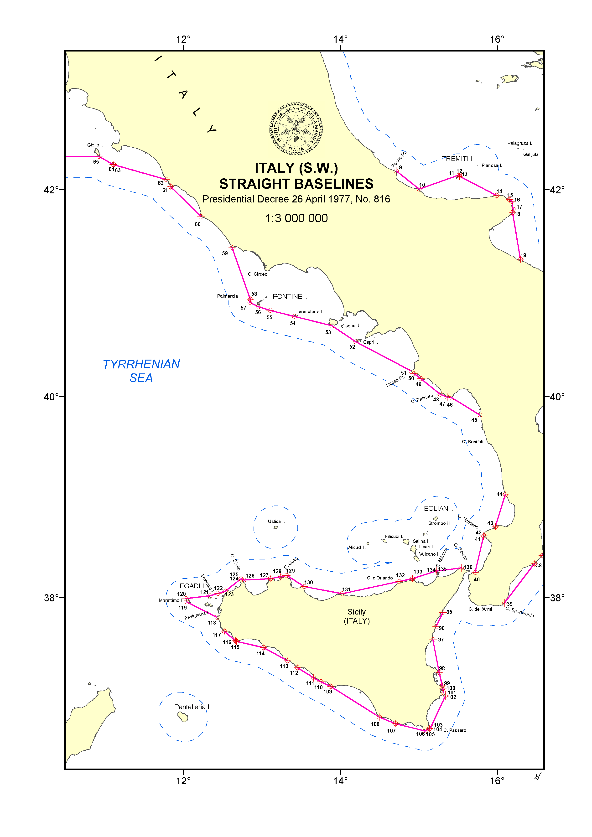
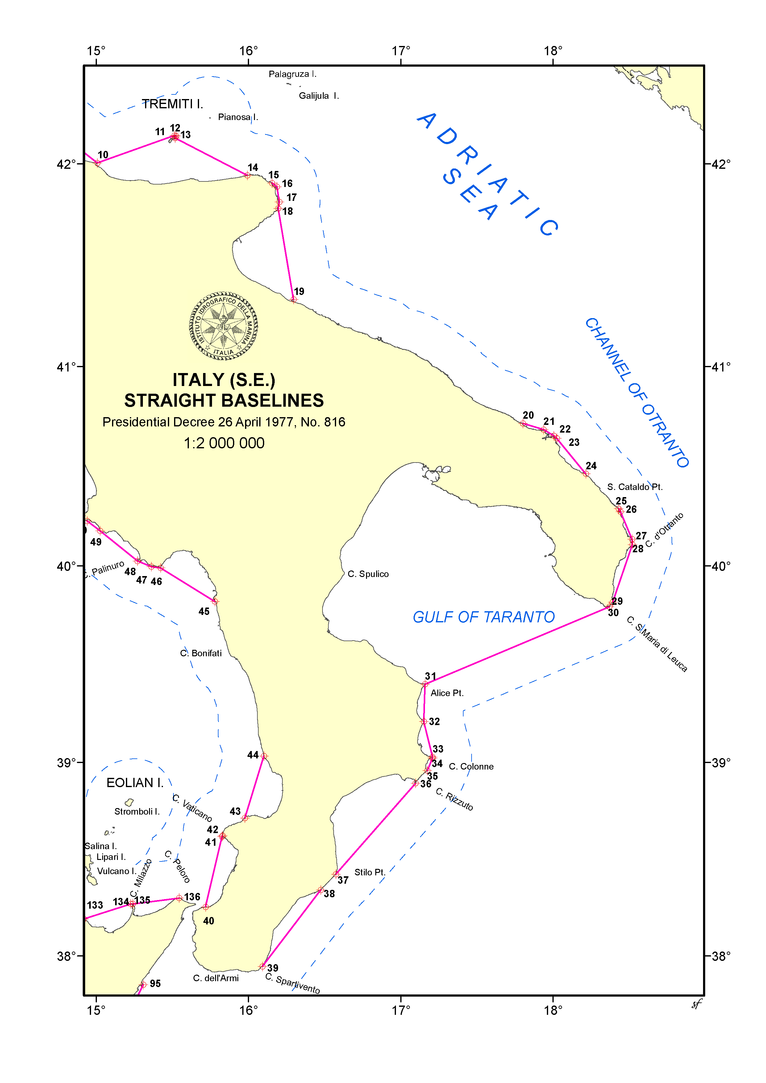
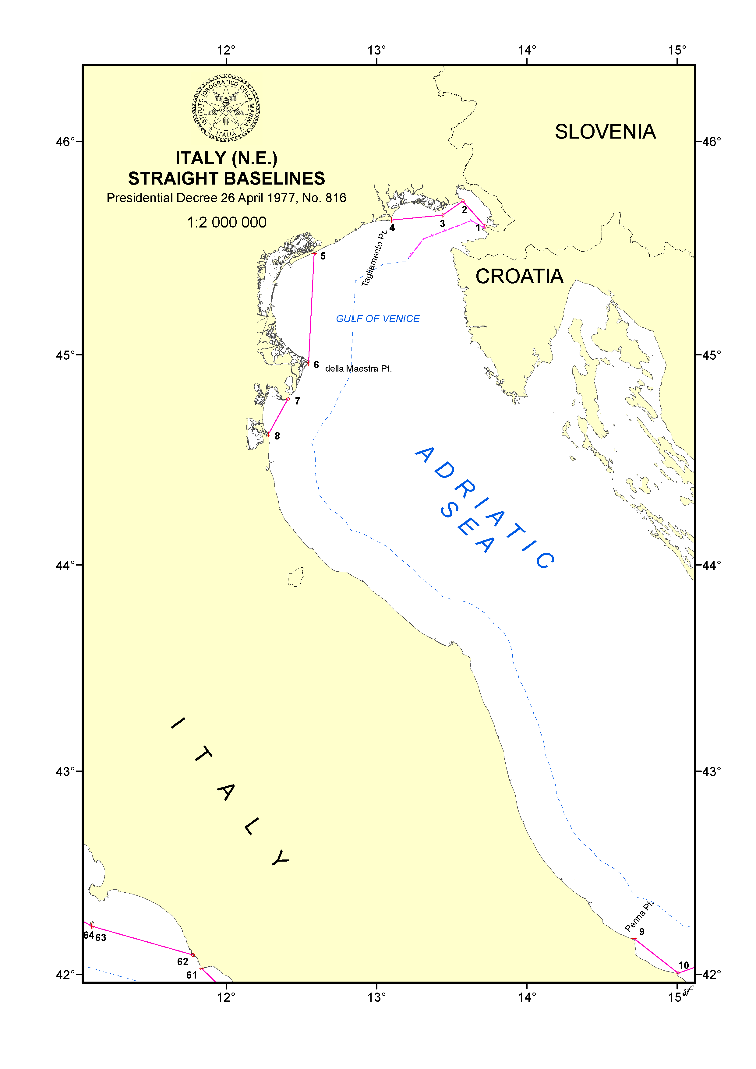
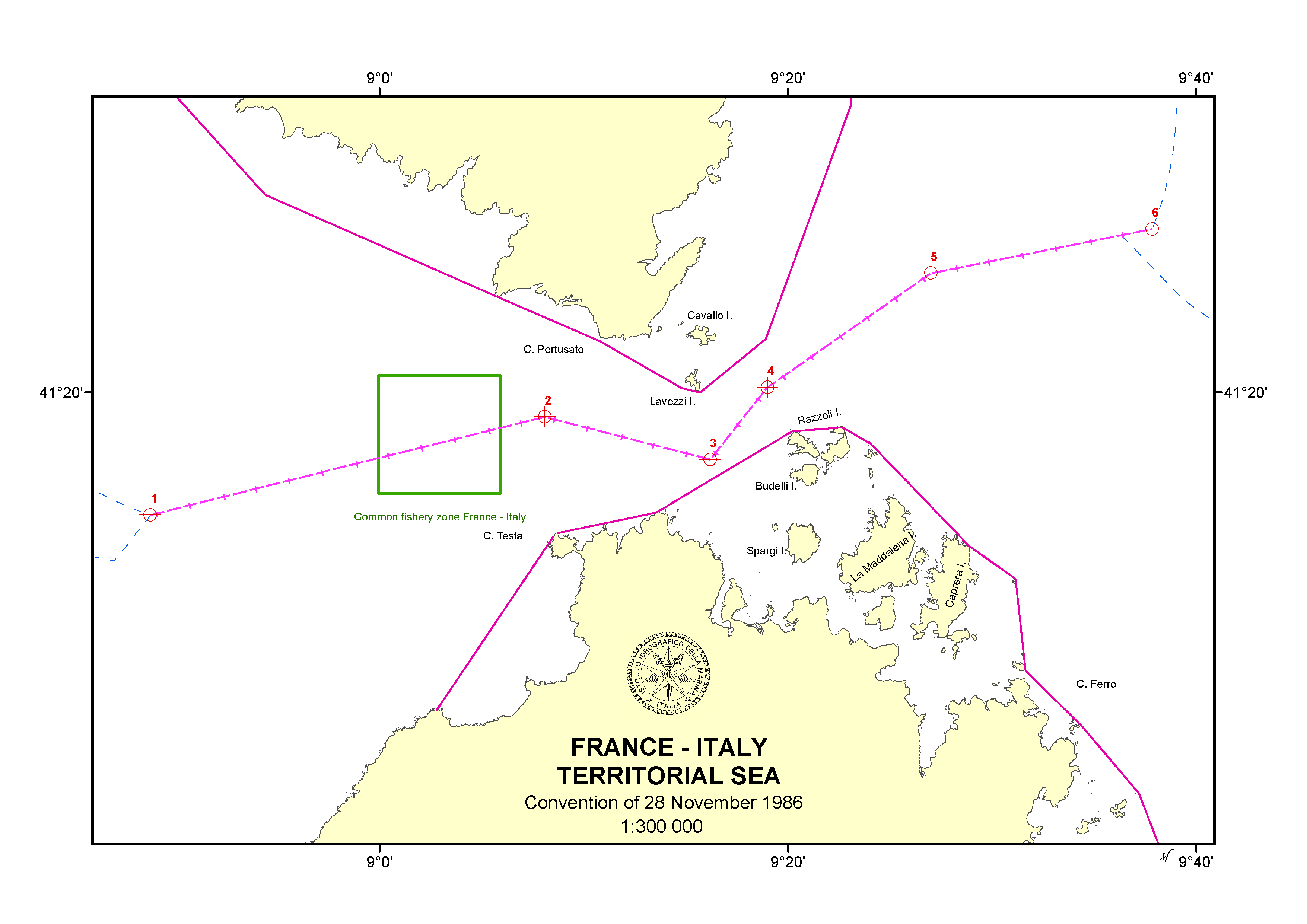
This interdisciplinary exercise was illustrated in Genoa in February 2023 at the Fourth Expert Meeting of the Working Group, considering that one of the objectives of the latter is to “play a leading role at the policy level by raising political awareness and highlighting the importance of reliable, timely, and fitfor-purpose marine geospatial information to support the administration, management, and governance of the marine environment”46. Consistently with this objective, all data used to design the illustrative maps in the Atlas are reliable and available at the global scale, since they are deposited with the United Nations Secretary-General; they are timely, because it is crucial, in the context of international relations, for a State to be put in the position to show acquiescence or notify a formal objection with respect to a maritime claim expressed in the form of a chart or list of geographical coordinates of points; and they are fit-for-purpose, as the law of the sea pursues, among other things, the essential objective of making limits and boundaries certain and definite in an environment which is fluid and characterized by ever-changing conditions. As such, these data may effectively support the administration, management, and governance of the marine environment, from the local to the global level, depending on the extent of the exercise. In other words, the Atlas works as an elemental MSDI, as it comprises a spatial database to store marine geospatial data, a data catalogue constituted by the legal texts comprising the lists of geographical coordinates of points, and it is publicly accessible in the form of a living study.
The challenges encountered in the drafting of the Atlas related, inter alia, to the following aspects: the geodetic datum used by States often is not specified; the points used are often defined by both their name and geographical coordinates, but without any indication of the system of identification to be preferred between the two; the lines between the points are often referred to without any indication on whether they are geodesic or loxodromic lines; and the link between straight baselines and normal baselines is not properly clarified (however, baselines should be continuous and, where straight baselines are not used, the normal baselines should be extracted from official charts and specified in the relevant legal text).
As a matter of fact, closely related to the issue of depositing geospatial information of maritime limits and boundaries there is not only the question concerning the authoritativeness of such data, which is undoubtful when it comes from a State representative, but also the question concerning their adherence to relevant technical standards that enable their effective use at the international level. In the realm of maritime limits and boundaries, this in turn contributes to ensuring certainty in international relations: it is important that all States be adequately informed about baselines, outer limits of maritime zones and their lines of delimitation, so that the users of the oceans could conform to the legal regime applicable to the maritime zones in which they operate.
Authoritativeness of data and their adherence to specific standards are, actually, two crucial issues for any data collection, transmission, sharing, and dissemination. Marine geospatial data can be stored in various formats and calibrated to different standards. As a consequence, any initiative aimed at comparing, combining, or mapping the data typically necessitates substantial data-cleaning and reformatting efforts.
With respect to geospatial data subject to due publicity obligations, it is to be noted that DOALOS provided effective guidance. The latest UNGA omnibus resolution, in para. 7, recalled the note of 2020 on the Practice of the Secretary-General in respect of the deposit of charts and/or lists of coordinates of points under the United Nations Convention on the Law of the Sea47 and the 2021 publication entitled Guidelines on deposit with the Secretary-General of charts and lists of coordinates of points under the United Nations Convention on the Law of the Sea48 (the 2021 Guidelines), both prepared by the Secretariat.
The former document contains a description of the legal framework for the exercise of the depositary functions by the Secretary-General under the UNCLOS, an overview of the practice of coastal States and of the Secretary-General, including technical aspects, a review of the practice of the Secretary-General in giving publicity to the deposited information, and recommendations for the attention of States Parties to the UNCLOS in relation to certain aspects of the obligations of deposit and related depositary functions. Notably, the Secretary-General has also accepted deposits made by States that are not yet Party to the UNCLOS49. The document highlights that the practice of States shows the diversity of approaches with regard to the technical aspects of the act of deposit and, accordingly, calls upon States to consider, when making a deposit, formatting the lists of geographical coordinates of points in accordance with applicable technical standards.
The second publication specifies such standards. Endeavors similar to the one undertaken in the Atlas would be extremely facilitated if all States followed the requirements listed in this publication, namely: provide the list of geographical coordinates of points referenced to WGS84, or provide all necessary parameters for the conversion of the deposited geographical coordinates from the original datum into WGS84; specify which sets of points in the lists are to be connected and constitute single lines, which is particularly useful in case States adopt mixed systems of normal and straight baselines as well as in case of maritime zones around islands (to ensure that the last point in the list connects back to the first point); and specify how the points included in a list of geographical coordinates are to be connected (i.e., whether by geodesics, loxodromes, or arcs constructed at a specific distance from defined centre points on the baseline, which would also need to be included in the deposit)50. As a matter of fact, all the listed requirements would be entirely covered if depositing States followed the IHO product specification S-121 Maritime Limits and Boundaries (Beaupré et al., 2022). Moreover, to facilitate the drafting of communications with the Secretary-General, the 2021 Guidelines provide a template in annex II.
On this matter, a last consideration lies in the fact that illustrative maps showing baselines, outer limit lines or lines of delimitation, such as those elaborated in the Atlas by the IIM and the author, can be considered as “supplementary information” by the depositing State according to the 2021 Guidelines. Obviously, such illustrative maps do not qualify as, and cannot substitute, nautical charts, i.e. charts that are based on hydrographic surveys and are specifically designed to meet the requirements of marine navigation51. Additional questions, concerning the deposit by States of nautical charts instead of lists of geographical coordinates of points, are not addressed in this contribution, although they are addressed in the 2021 Guidelines52. The Atlas pointed only at providing the visual representation of such marine geospatial data information that would not be otherwise apprehensible at first sight.
5 Final remarks
The request for the publication contained in the UNGA omnibus resolution and directed to the Secretary-General enhances the mandate of the IHO and DOALOS, as well as of United Nations bodies and processes such as UN-GGIM and its relevant working groups, and places marine geospatial information management among the current top interests of the Member States, having gained attention from the principal representative organ of the United Nations for deliberation and policy-making53. Such an opportunity should be seized by all States and stakeholders in the various disciplinary sectors that make use of marine geospatial data.
Given the extensive scope of the analysis requested to the Secretary-General and the multitude of marine geospatial data and relevant applications, it would be desirable for the forthcoming publication to be progressively integrated through additional issues focusing on the different kinds of application of hydrographic information as well as on marine geospatial data of non-hydrographic nature that could integrate the former. A data-centric “living document” could better serve the Member States in the development of the various sectors of marine geospatial endeavours, as well as in the understanding of their interoperability.
In the preparation of milestone publications of this kind, the role of hydrographic offices worldwide would be prominent. This contribution aimed at showing the great potential of the interactions between lawyers and hydrographers in one of the most ancient, and yet most dynamic, realms of international law (Tanaka, 2023). It is the hope of the author that this Review will be willing to host further contributions related to the technical aspects of the law of the sea54, covering, inter alia, the complex discipline concerning the law (and case law) of maritime limits and maritime boundary delimitations.
Never had such support been demonstrated so widely at the international level for the topic of marine geospatial data. Current initiatives within the IHO, the UNGA, and ECOSOC intertwine substantially, and their cumulative efforts, supported by the contributions of national hydrographic offices, can lead to an unprecedented strengthening of marine geospatial information management arrangements within and across Member States, moreover in an integrated manner.
Acknowledgements
The author wishes to thank John Nyberg, Director of the IHO, for reading the draft and providing valuable comments, as well as Robert Sandev, Senior GIS Officer of UN DOALOS, for his continuous support over the years and the helpful exchanges we have had in New York. The views expressed are solely those of the author and do not imply any position of the two institutions.
References
Antunes, M. N. (2003). Towards the Conceptualization of Maritime Delimitation: Legal and Technical Aspects of a Political Process. Leiden: Brill/Nijhoff.
Bardonnet, D. (1976). Les frontières terrestres et la relativité de leur tracé: (Problèmes juridiques choisis).Collected Courses of the Hague Academy of International Law, 153, 9-166.
Bardonnet, D. (1989). Frontières terrestres et frontières maritimes. Annuaire français de droit international, 35(1), 1–64.
Beazley, P. B. (1971). Territorial Sea Baselines. The International Hydrographic Review, 48(1), 143–154.
Beazley, P. B. (1987). Maritime Limits and Baselines: A Guide to Their Delineation. The Hydrographic Society, Special Publication No. 2, London.
Beaupré, J.-F., Lévesque, S., Ahola, R., Durand, S., Douglas O’Brien, C., Pritchard, J. and Alcock, M. (2022). Development of S-121 for Maritime Limits and Boundaries. The International Hydrographic Review, 28, 94–107.
Carleton, C. and Schofield, C. (2001). Developments in the Technical Determination of Maritime Space: Charts, Datums, Baselines, Maritime Zones and Limits. Maritime Briefing, 3. Durham: International Boundary Research Unit.
De Visscher, C. (1967). Les effectivités du droit international public. Paris: Pedone.
Fietta, S. and Cleverly, R. (2016). A Practitioner’s Guide to Maritime Boundary Delimitation. Oxford: Oxford University Press. Fowler, C., Smith, B. F., Stein, D. (2010). Building a Marine Spatial Data Infrastructure to Support Marine Spatial Planning in U.S. Waters. National Oceanic and Atmospheric Administration (NOAA), Coastal Services Center: Charleston, United States of America.
Grbec, M., Scovazzi, T., and Tani, I. (2023). Legal Aspects of Marine Protected Areas in the Mediterranean Sea: An Adriatic and Ionian Perspective. London and New York: Routledge.
Kunoy, B. (2020). Classification of Seafloor Highs According to Legal Hermeneutics. Asian Journal of International Law, 10, 196–232.
Kunoy, B. (2023). Recommendations on the Russian Federation’s Proposed Outer Continental Shelf in the Arctic Area. EJIL:Talk! Blog of the European Journal of International Law.
Lando, M. (2019). Maritime Delimitation as a Judicial Process. Cambridge: Cambridge University Press.
Lathrop, C. G., Roach, J. A. and Rothwell, D. R. (2019). Baselines under the International Law of the Sea: Reports of the International Law Association Committee on Baselines under the International Law of the Sea. Leiden: Koninklijke Brill NV.
Pearcy, G. E. (1959). Geographical Aspects of the Law of the Sea. Annals of the Association of American Geographers, 49(1), 1–23.
Prescott, J. R. V. (1985). Straight Baselines: Theory and Practice. In Brown, E. D. and Churchill, R. R. (eds.), The United Nations Convention on the Law of the Sea: Impact and Implementation. Proceedings of the Nineteenth Annual Conference of the Law of the Sea Institute, Honolulu: Law of the Sea Institute.
Prescott, J. V. R. and Schofield, C. (2005). The Maritime Political Boundaries of the World (2nd edition). Leiden: Martinus Nijhoff. Proelss, A. (2017). United Nations Convention on the Law of the Sea: A Commentary. München-Oxford-Baden-Baden: C. H. Beck-Hart-Nomos.
Reed, M. W. (2011). An Attempt to Unravel Charting and Publicity Requirements Imposed by UNCLOS Article 16. In Symmons, C. R. (ed.), Selected Contemporary Issues in the Law of the Sea. Leiden: Martinus Nijhoff.
Rothwell, D. R. (2022). Islands and International Law. Oxford: Hart Publishing.
Schofield, C. (2012). Departures from the Coast: Trends in the Application of Territorial Sea Baselines under the Law of the Sea Convention. The International Journal of Marine and Coastal Law, 27(4), 723–732.
Schofield, C. (2019). The Regime of Islands Reframed: Developments in the Definition of Islands under the International Law of the Sea. Brill Research Perspective on the Law of the Sea, 3(1-2), 1–126.
Schofield, C. (2021). A New Frontier in the Law of the Sea? Responding to the Implications of Sea Level Rise for Baselines, Limits and Boundaries. In Barnes, R. and Long, R. (eds.), Frontiers in International Environmental Law: Oceans and Climate Challenges: Essays in Honour of David Freestone. Leiden: Brill/ Nijhoff, 171193.
Scovazzi, T. (1986). La linea di base del mare territoriale. Milan: Giuffré.
Scovazzi, T. (1988). Bays and Straight Baselines in the Mediterranean. Ocean Development and International Law, 19(5), 401–420.
Strohl, M. P. (1963). The International Law of Bays. The Hague: Martinus Nijhoff.
Symmons, C. R. and Reed, M. W. (2010). Baseline Publicity and Charting Requirements: An Overlooked Issue in the United Nations Convention on the Law of the Sea. Ocean Development and International Law, 41(1), 77–111.
Tanaka, Y. (2006). Low-Tide Elevations in International Law of the Sea: Selected Issues. Ocean Yearbook, 20, 189–219.
Tanaka, Y. (2019). Predictability and Flexibility in the Law of Maritime Delimitation (2nd edition). Oxford: Hart.
Tanaka, Y. (2023). The International Law of the Sea (4th edition). Cambridge: Cambridge University Press.
Tani, I., Ferrero, S. and Pizzeghello, M. N. (2020). Atlas of Maritime Limits and Boundaries in Central Mediterranean: Legal Texts and Illustrative Maps. Genoa: Istituto Idrografico della Marina.
Tani, I. and Tarassenko, S. (2012). The Functions and Role of the United Nations Secretariat in Ocean Affairs and the Law of the Sea. International Journal of Marine and Coastal Law, 27(4), 683–699.
Vukas, B. (2007). Sea Boundary Delimitation and Internal Waters. In Ndiaye, T. M. and Wolfrum, R. (eds.), Law of the Sea: Environmental Law and Settlement of Disputes – Liber Amicorum Judge Thomas A. Mensah. Leiden-Boston: Martinus Nijhoff.
Westerman, G. S. (1987). The Juridical Bay. New York-Oxford: Oxford University Press.
Author’s biography

Attorney-at-Law in Milan (Italy). Adjunct Professor of International Law of the Sea, Ocean Affairs Law and Policy, and Maritime and Aviation Law at University of Milano-Bicocca (Italy). Deputy-Director of the PhD programme in Marine Sciences, Technology and Management at University of Milano-Bicocca (Italy). Member of the Italian Delegation in United Nations and IHO working groups, negotiations, and processes related to the law of the sea, including its technical aspects. Legal consultant for States, private sector, and international secretariats on matters related to the law of the sea. Former Associate Legal Officer at the Division for Ocean Affairs and the Law of the Sea, Office of Legal Affairs, United Nations (UN DOALOS, New York, United States of America).
- See General Assembly resolution 77/248 of 30 December 2022.
- The omnibus resolution deals with all ocean-related topics that are not specifically linked to fishing activities, which is the detailed subject of a separate resolution adopted annually by the General Assembly, namely on Sustainable fisheries, including through the 1995 Agreement for the Implementation of the Provisions of the United Nations Convention on the Law of the Sea of 10 December 1982 relating to the Conservation and Management of Straddling Fish Stocks and Highly Migratory Fish Stocks, and related instruments.
- Currently, the Parties to the UNCLOS are 169, including the European Union.
- The UNCLOS counts three implementing agreements, namely: the Agreement relating to the Implementation of Part XI of the United Nations Convention on the Law of the Sea of 10 December 1982 (New York, 1994), the Agreement for the Implementation of the Provisions of the United Nations Convention on the Law of the Sea of 10 December 1982 relating to the Conservation and Management of Straddling Fish Stocks and Highly Migratory Fish Stocks (New York, 1995), and the recent Agreement under the United Nations Convention on the Law of the Sea on the Conservation and Sustainable Use of Marine Biological Diversity of Areas beyond National Jurisdiction (New York, 2023).
- See DOALOS letters of 6 January 2023 addressed to the Permanent Missions of Member States and the Delegation of the European Union to the United Nations.
- It is to be noted the absence of representatives of other Regional Sea Conventions and Action Plans (RSCAPs), including those established under the auspices of the United Nations Environment Programme (UNEP) as well as the independent RSCAPs. OSPAR was not established by UNEP but cooperates with the latter’s Regional Seas Programme and attends its regular meetings.
- See DOALOS letters of 20 June 2023 addressed to the Permanent Missions of Member States and the Delegation of the European Union to the United Nations, as well as to relevant international governmental organizations.
- For instance, when the map of a tsunami (depicting location and time) is overlaid with another layer showing potentially vulnerable coastal areas, that is an example of GIS in action.
- A distinct case is presented by archipelagic baselines, which are drawn according to precise geometric rules and mathematical proportions as defined in Article 47 UNCLOS.
- Notably, on the continental shelf, only the delineation of the course of pipelines (not cables) is subject to the consent of the coastal State. Geospatial information is obviously crucial for works related to the laying of both cables and pipelines in all marine spaces.
- Prominent in this respect is the Agreement for the Implementation of the Provisions of the United Nations Convention on the Law of the Sea of 10 December 1982 relating to the Conservation and Management of Straddling Fish Stocks and Highly Migratory Fish Stocks (New York, 1995). Under Article 118 UNCLOS, States are also required to cooperate to establish subregional or regional fisheries organizations to conserve and manage living resources in areas of the high seas. So-called regional fisheries management organizations (RFMOs), as well as less institutionalized mechanisms of conservation named regional fisheries management arrangements (RFMAs), have been established, mainly for the management of specific species (i.e., highly migratory species, mostly tuna) or non-tuna stocks within particular geographical areas. Whaling is subject to the International Convention for the Regulation of Whaling (Washington, 1946) and several regional treaties deal with the conservation of marine mammals, such as the seals of the Northwest Atlantic, Antarctica, and Wadden Sea, as well as specific species of cetaceans or other marine mammals of the Baltic, North Atlantic, Irish and North Seas, Black Sea, and Mediterranean Sea.
- Agreement relating to the Implementation of Part XI of the United Nations Convention on the Law of the Sea of 10 December 1982 (New York, 1994). A set of regulations adopted by the International Seabed Authority concerns the exploration of three kinds of minerals of the seabed and ocean floor and subsoil thereof, beyond the limits of national jurisdiction. Draft regulations on the exploitation of mineral resources of the Area are awaiting formal adoption.
- Part XII UNCLOS is devoted to the protection and preservation of the marine environment and enshrines general obligations. A variety of global and regional legal and policy instruments specify such general framework. Notably, Part IV of the recent Agreement under the United Nations Convention on the Law of the Sea on the Conservation and Sustainable Use of Marine Biological Diversity of Areas beyond National Jurisdiction (New York, 2023), inter alia, operationalizes the UNCLOS provisions for areas beyond national jurisdiction by establishing processes, thresholds, and other requirements for conducting and reporting environmental impact assessments by States Parties.
- The UNCLOS does not expressly mention MPAs: it only implicitly refers to them in Article 194, para. 5. MPAs are mostly establish at the national level on the basis of domestic legislation; however, MPAs may also reach an international dimension, especially where they have a transboundary character or are intended to be included in networks that occur in semi-enclosed seas bordered by several countries (Grbec et al. 2023). The subject of MPAs is regulated by a number of international treaties concluded at global, regional, and sub-regional level. The complementary notion of OECMs is relatively recent, having been defined in 2018 by the States Parties to the Convention on Biological Diversity (Decision XIV/8).
- Part XIII UNCLOS is devoted to the regulation of marine scientific research. Relevant references are included also elsewhere, e.g., in Articles 21 (territorial sea), 40 (straits used for international navigation), 56 (exclusive economic zone), and 143 (Area).
- In this regard, see the recent Agreement under the United Nations Convention on the Law of the Sea on the Conservation and Sustainable Use of Marine Biological Diversity of Areas beyond National Jurisdiction (New York, 2023).
- It is in fact the line that naturally separates the water and terrestrial domains.
- Unlike the normal baseline, which runs along the natural divide between land and water, straight baselines run in the sea.
- A continental shelf is deemed to extend up to 200 nautical miles if the outer edge of the continental margin does not extend up to that distance (Article 76, para. 1, UNCLOS)
- Notwithstanding their name, the recommendations of the CLCS are “final and binding” (Article 76, para. 8, UNCLOS).
- In the absence of evidence to the contrary, the foot of the continental slope shall be determined as the point of maximum change in the gradient at its base (Article 76, para. 4, b, UNCLOS).
- This rule raises further complexities linked to names and definitions of underwater features.
- Where no boundary treaty is concluded
- See Article 15 UNCLOS for the delimitation of the territorial sea and Articles 74 and 83 UNCLOS for the delimitation of the continental shelf and the exclusive economic zone, respectively. There is no provision in the UNCLOS (nor in any previous convention) concerning the delimitation of the contiguous zone.
- According to Article 5 UNCLOS, the normal baseline coincides with the low-water line along the coast “as marked on large-scale charts officially recognized by the coastal State”, hence allowing States a certain degree of discretion in choosing such line.
- The preferred geodetic datum is based on World Geodesic System 84 (WGS 84), as this contribution will recall shortly.
- Obligations of due publicity entailing geospatial information are also provided in the UNCLOS in Articles 21, para. 3 (laws and regulation concerning, inter alia, the safety of navigation and the regulation of maritime traffic, the protection of navigational aids and facilities, the protection of cables and pipelines), 22, para. 4 (sea lanes and traffic separation schemes in the territorial sea), 41, paras. 2 and 6 (sea lanes and traffic separation schemes in straits used for international navigation), 42, para. 3 (transit passage, safety of navigation, and the regulation of maritime traffic in straits used for international navigation), and 53, paras. 7 and 10 (sea lanes and traffic separation schemes in archipelagic waters).
- Para. 90 of the latest UNGA omnibus resolution called upon coastal States that have not yet done so to deposit a copy of charts or lists of geographical coordinates showing the outer limit lines of the continental shelf with the Secretary-General of the ISA, as provided for in Article 84, para. 2, UNCLOS.
- Nevertheless, certain deposits related to the outer limit lines of the continental shelf have been made by some coastal States exclusively with either the Secretary-General of the United Nations or the Secretary-General of the ISA. A note prepared by the Secretariat on the Practice of the Secretary-General in respect of the deposit of charts and/or lists of geographical coordinates of points under the United Nations Convention on the Law of the Sea (SPLOS/30/12), in para. 25, recalls that, pursuant to Article 8 of the Agreement concerning the Relationship between United Nations and the International Seabed Authority, the secretariats of the United Nations and the ISA have developed a practice of periodically sharing information concerning charts and/or lists of geographical coordinates of points defining the outer limits of the continental shelf.
- The object of the deposit under the UNCLOS is the chart or the list. However, as this geospatial data information is usually contained in, or appended to, national legislation or boundary delimitation agreements, their transmission in the context of the deposit has been considered as supplementary material and information. Judgments or awards settling maritime delimitation cases may be also referred to at the time of deposit, as supplementary information.
- The act of deposit under the UNCLOS also differs from other obligations of States such as the registration of treaties under Article 102 of the Charter of the United Nations, even though boundary treaties registered under that provision may contain information required under the UNCLOS. As no Party to a treaty that has not been registered under Article 102 of the Charter of the United Nations may invoke that treaty before any organ of the Organization, the Secretariat requires that treaties containing geospatial information related to maritime boundary delimitations be first registered under that provision, prior to their transmission to DOALOS.
- See General Assembly resolution 49/28, para. 15 (f), of 6 December 1994, and General Assembly resolution 52/26, para. 11 (c), of 26 November 1997
- See http://www.un.org/Depts/los/LEGISLATIONANDTREATIES/losics.htm (accessed 8 Sep. 2023). This webpage of the DOALOS website is one component of the facilities established upon request of the General Assembly. This is where all information related to deposits is brought into the public domain in a format of electronic files available for download.
- A periodic publication issued by DOALOS three times a year, with editorial closing dates of 31 March, 31 July, and 30 November. See https://www.un.org/depts/los/doalos_publications/los_bult.htm (accessed 8 Sep. 2023).
- Most communications included reactions of other States with respect to the constructions of baselines by the depositing States. Other communications addressed issues related to low-tide elevations, rocks, lack of access to certain maritime zones, the unilateral nature of a delimitation or its methodology, and sovereignty.
- Besides the IHO, the main geospatial standards development organizations are the International Organization for Standardization (ISO) and the Open Geospatial Consortium (OGC). The latter, in particular, led a pilot project to improve the data model and formulate recommendations to the IHO on the standards in question.
- Version 1.0.0 of S-121, with annexes, is available for download from the IHO Geospatial Information Registry.
- See para. 5 of General Assembly resolution 77/248 of 30 December 2022.
- ISO/IEC Directives, Part 2, Rules for the Structure and Drafting of International Standards, 2021, section 3.1.2.
- In this regard, see the initiative launched in 2022 by the IIM and funded by the European Union in the context of the Interreg project MedOsmosis: https://geo.istitutoidrografico.it/en/#/en/home (accessed 8 Sept. 2023). It is a web interface in the form of a geoportal, designed to facilitate and speed up the exchange of authoritative nautical information between public and private entities and the IIM. Access to the geoportal is allowed, permanently or temporarily, through the release of credentials. The account is nominative, and the authorization levels are defined on the basis of the specific needs of the user. Coast Guard officers, public authorities (ministerial offices, research institutions, local authorities), private companies, concessionaries, individuals with a specific interest in maritime activities may enter and use the portal with different levels of interactions. All registered users are able to transfer authoritative marine information quickly and in a simple way: equipped with a system of graphic tools for the planning of initiatives, they can submit information for technical cartographic check by the hydrographic office. The latter can automate the process of entering new features or updating products, streamlining the interactions with the Coast Guard and local maritime authorities.
- As acknowledged in decision 13/111 of the UN-GGIM, adopted on 4 August 2023.
- Document available at https://ggim.un.org/meetings/GGIM-committee/13th-Session/documents/UN-IGIF-Hydro%20Part%20One%20-%20The%20Strategic%20Overview_20230725.pdf (accessed 8 Sept. 2023).
- Document available at https://ggim.un.org/meetings/GGIM-committee/13th-Session/documents/UN-IGIF-Hydro%20Part%20Two%20-%20The%20Strategic%20Pathways.pdf (accessed 8 Sept. 2023)
- The plenary of UN-GGIM, in endorsing the complete UN-IGIF-Hydro in decision 13/111, included the language “having noted that some Member States may disassociate themselves from any references made to the United Nations Convention on the Law of the Sea (UNCLOS) that they are not party to”. As a matter of fact, such disassociation was expressed by only one Member State that, moreover, had not participated in the global consultations, while all other Member States, even those that are not parties to the UNCLOS, had been active participants and relied on consensus. It is the view of the author that any reference to the UNCLOS made in UN-IGIFHydro reflects the customary law of the sea, as such binding upon all States.
- The author participated in the meetings of the regional group UN-GGIM:Europe at the United Nations, during the Thirteenth Session of UN-GGIM (2-4 August 2023).
- See Terms of Reference of the UN-GGIM Working Group on Marine Geospatial Information, 2. Objectives, 2.1
- SPLOS/30/12.
- Available at https://www.un.org/Depts/los/doalos_publications/publicationstexts/DepositGuidelinesEnglish.pdf (accessed 8 Sept. 2023).
- This was justified “in view of the universal and unified character of the Convention and overarching interests in promoting legal certainty and transparency regarding maritime zones and limits, and given that the Convention does not appear to preclude non-parties from voluntarily implementing its relevant provisions” (para. 23 of the note). That the depositing State is not a party to the UNCLOS was explicitly noted in the corresponding maritime zone notification. See maritime zone notification M.Z.N.66.2009.LOS of 10 March 2009, available at https://www.un.org/Depts/los/LEGISLATIONANDTREATIES/STATEFILES/ARE.htm (accessed 8 Sept. 2023).
- Alternatively, coastal States may consider depositing a list of geographical coordinates of points extrapolated from the geodesics, loxodromes or arcs, located at short distances, so that, when connected, the resulting line will be the same as the geodesic, loxodrome or arc from which they were extrapolated. See para. 29 (c) of the 2021 Guidelines.
- See para. 19 of the 2021 Guidelines.
- See paras. 19 to 26 of the 2021 Guidelines.
- This fact was emphasized in the Italian statement in the plenary of UN-GGIM on 4 August 2023.
- As addressed in IHO Publication S-32, IHO Hydrographic Dictionary, and IHO Publication C-51, A Manual on Technical Aspects of the United Nations Convention on the Law of the Sea – 1982.