


Abstract
1 Introduction
The International Hydrographic Organization (IHO) and the International Maritime Organization (IMO) are organizations that work together for maritime safety as a common goal, through regulation, harmonization of publications, and nautical products. One of these essential nautical products for navigation safety are nautical charts.
The IHO, in order to unify the use of digital cartography, published the Digital Hydrographic Data Transfer S-57 standard for the production of electronic navigational charts (ENC; IHO, 2000), which allows the data of the paper nautical chart to be transferred digitally and in a standardized form in terms of their content, attributes, and element encoding to an ENC (Zou et al., 2012).
To maintain high standards of navigational safety, the IMO through the resolution of the Maritime Safety Committee No. 282 of 1986 approved the use of ENCs as equivalent to paper nautical charts, provided that they are updated and are used in Electronic Chart Display and Information Systems (ECDIS; IMO, 2009). This has led to the fact that since 2018, the use of ECDIS is mandatory for regulated vessels (IMO, 2017).
In order to promote the safe use of ECDIS for navigation, the IHO must coordinate and to ensure a worldwide consistent level of high-quality, updated official ENCs through integrated services that support chart carriage requirements of Safety of Life at Sea SOLAS Chapter V (M-3). Through its support for a carriage requirement for ECDIS, the IHO is pushing the shift from paper charts to electronic navigation. As a result, the IHO should ensure that mariners receive adequate ENC services through so-called WEND principles (IHO, 2023a).
The WEND principles guide ENC producing agencies to ensure uniformity and high quality of the ENCs they produce (IHO-IRCC, 2017). Worldwide, the validation and distribution of ENCs is the responsibility of the two regional ENC coordinating centers (RENCs), PRIMAR and The International Center for ENC (IC-ENC). RENCs which are organizational entities where IHO members have established cooperation amongst each other to guarantee a worldwide consistent level of high-quality data, share a common experience, reduce expenditure, and ensure the greatest possible standardization, consistency, reliability, and availability of ENCs. In 2023, PRIMAR reported coverage of 19,087 ENC (PRIMAR, 2023), and IC-ENC reaching 10,000 ENCs in distribution, covering much of the world’s oceans made by the 48 member countries (IC-ENC, 2023). This indicates the progress in production worldwide, as a consequence of a greater number of users of ENC in ECDIS (Moggert-Kägeler, 2018).
At a global level, the current coverage of ENCs presents multiple problems, such as, different designs in cartographic schemes, non-uniform cell sizes, irregularity in data representation due different compilation scales between ENC in the same navigational purpose, gaps and overlaps in contiguous ENCs, among others. Therefore, almost three decades after the S-57 standard for ENCs was published, there are still problems related to its implementation (Kastrisios & Pilikou, 2017).
The IHO, in the continuous search to harmonize coverage, has 15 Regional Hydrographic Commissions (RHC) to coordinate hydrographic activity and cooperation at the regional level between Member States (MS), which are governed by resolution 2 of 1997 (IHO, 2018c). In turn, it has an Inter-Regional Coordination Committee (IRCC) supervises the IHO Capacity Building Strategy, promotes the wider use and collection of marine data and is responsible for the policy matters related to the Worldwide Electronic Navigational Chart Database (WEND) with the objective of harmonizing the activities of the Chairs of the RHCs with respect to regional responsibilities (IHO, 2023b).
One of these responsibilities of the RHCs is the maintenance of an adequate scheme of ENC. Having standardized cartographic schemes at the regional level is an important step to improve the quality and coverage of ENCs, and therefore, to contribute to navigational safety. In November 2021, during IC- ENC Steering Committee meeting, the IC-ENC Members discussed the IC-ENC overlapping ENC policy where identified that overlapping data causes serious problems for users of certain ECDIS. Currently, ENCs in the Caribbean Sea are distributed through the IC-ENC, who reported 106 cases of overlaps for the Meso American & Caribbean Sea Hydrographic Commission (MACHC) including cases of reverse scale/purpose overlaps between producers (IC- ENC, 2022). The big challenge among producers arises each time a new cell is produced, and they must agree on who has the responsibility to remove or modify the published ENC. Having a coherent and updated ENC scheme offers the following benefits: (i) uniform coverage in electronic cells, (ii) consistent cartographic information covering specific areas at appropriate scales for different navigational purposes, (iii) eliminate inconsistency information in overlapping areas, and (iv) efficient use of the resources used in the compilation of ENCs.
ENCs are tools that provide essential information about the marine and coastal environment to mariners for planning and executing their voyages. According to (Kastrisios et al., 2023) its compilation follows strict cartographic constraints with the most prominent being that of the safety and must always be respected. During the period 2008 to 2018 there were 80 grounding accidents of which 22 cases were related to ECDIS and ENCs (Turna & Öztürk, 2020), the quality of products is extremely important as it improves maritime safety, for example correct data representation, reefs and buoys, ENC datum in WGS84, depth soundings in meters and soundings with true position, Failure to comply with this standard can lead to maritime accidents, environmental pollution and loss of life. But there are also other regional benefits such as the safe and effective control of maritime transport, supporting economic development in sectors such as tourism or international trade, having better information for the fight against drug trafficking, piracy and other crimes that occur at sea, among others.
This paper aims to provide the international charting agencies with a complete and adequate methodological proposal to standardize regional ENC schemes. The proposal that is developed in this study is applied in the Caribbean Sea in order to show the difficulties that arise, but also the benefits that are obtained from this implementation through the development of a case study. This area is covered by the MACHC, an organization with which this proposal has been discussed.
To achieve the main goal, it is necessary to fulfill the following objectives:
- Analyze the electronic nautical cartography schemes generated by the different countries in the Caribbean Sea in order to define their strengths and weaknesses for the different navigation purposes, within the framework of international regulations and other schemes implemented worldwide.
- Define the necessary criteria to standardize the electronic nautical cartography scheme at the level of the Regional Hydrographic Commissions, taking into account the international regulations and other nautical and cartographic criteria
- Design the cartography schemes based on the criteria defined for the different navigation purposes (Overview, General and Coastal) seeking to standardize the electronic cartography schemes in the Caribbean Sea and provide a solution to the limitations found in the current scheme.
- In accordance with the objectives, the paper is organized as follows. Section 2 presents the MACHC and its current ENC scheme, discussing its strengths and weaknesses. In Section 3, the proposed standardization methodology is discussed, while in Section
- 4, this methodology is used to formulate a proposed regional ENC scheme for the MACHC, presenting a comparison between the current and proposed ENC schemes, to highlight their differences and advantages. Finally, Section 5 presents a summary of the most important aspects of this work.
Actions taken to eliminate overlaps
Faced with the global problem of overlapping, the IHO promoted the study of the complexity of the issue (Moggert-Kägeler, 2018). Therefore, overlapping ENCs have been discussed in detail for years, preparing standards and documents under the synergy of the IHO, working groups, RHCs and the support of the RENCs.
In May 2016, the IRCC recommended that the Worldwide ENC Database Working Group (WENDWG) conduct research and prepare a draft resolution, with the aim to present the results and discuss them at the annual meetings. Indeed, IC-ENC started conducting a risk assessment, finding 246 cases among members’ overlapping ENCs, in January 2017, according to the IC-ENC’s Overlapping Data Policy & Reporting (IC-ENC, 2017). And in March 2018, the UKHO presented the historical ENC overlaps report from 2012 to 2017 indicating a reduction of 453 from 18,810 (UKHO, 2018). Consequently, the IHO as an alternative issued resolution to remove data from ENCs in areas of demonstrable risk to the safety of navigation (IHO, 2018a).
Over the past five years, RHCs have continued to present problems, especially when new ENCs are carried out. During WENDWG8 in 2018, a report was presented to some of the Commissions, which reported on the existence of overlaps that could have a potential impact on the safety of navigation, including that of the MACHC, with multiple potential overlaps with news cells.
In addition, as a result of the IRCC8/13 action, the RHCs expressed their interest in reducing overlaps through the application of the WEND Principles and the definition of approved ENC schemes. However, the situation among these varies depending on each one’s considerations and approaches to address the problem (WENDWG, 2018).
Taking into account the above, in 2019, Germany shared experiences since Baltic Sea Hydrographic Commission (BSHC) took the opportunity to start restructuring the old ENC coverage scheme with a new grid scheme, due the way BSH produced ENC was not harmonised. The ENC scheme is based on a regular bENC grid with a 2 × 2 minute extension (WENDWG, 2023).
Likewise, some nations such as Japan, Canada, Australia, Germany and Korea have migrated to a gridded ENC scheme and have done so independently, achieving harmonization exclusively for their country (IIC Technologies, 2021). Also, the National Geospatial Intelligence Agency (NGA) of the United States Department of Defense, since 2021 is in the process of creating a Worldwide ENC grid for use in building its future ENC. The grid will be comprised of regions which will be labeled with a letter as the region identification (SWPHC, 2021). Accordingly, the Southern African and Islands Hydrographic Commission (SAIHC) had discussions about potential benefits and disadvantages of gridded ENC scheme for region (SAIHC, 2020). However, at a regional and global level, there remain differences between the scales and cell sizes.
As many Hydrographic Offices (HO) move towards implementing seamless databases covering their entire areas of responsibility, the requirement to provide data as small ENC cells, focusing on S-100 products. According to (Pharaoh, 2009) during the TSMAD meeting proposes global spatial indexing Systems C-Squares should be considered for S-101. According to Marine Management Organisation, C-Square is an acronym for the concise spatial query and representation system, a system of spatially unique, location-based identifiers obtained by progressively subdividing 10° by 10° World Meteorological Organization squares into increasingly fine grids, including but not limited to the 0.05° by 0.05° grid above (MMO, 2023).
In the MACHC region, the United States started to restructure plan products (NOAA, 2017) and the United Kingdom (Rodwell, 2021) are analyzing this problem with their ENCs, seeking a solution also using a standardized grid scheme system.
Faced with the challenge, in 2022, The Global ENC Database Working Group at the WENDWG12 meeting, discussed the global future of ENCs coverage. ENCs for new digital products based on the S-100 in order to support navigation safety and search and rescue activities, mitigate impacts on marine pollution, among others. The objective of which, is the elimination of significant overlaps, achieving continuous coverage and harmonized production.
2 MACHC and its current ENC scheme
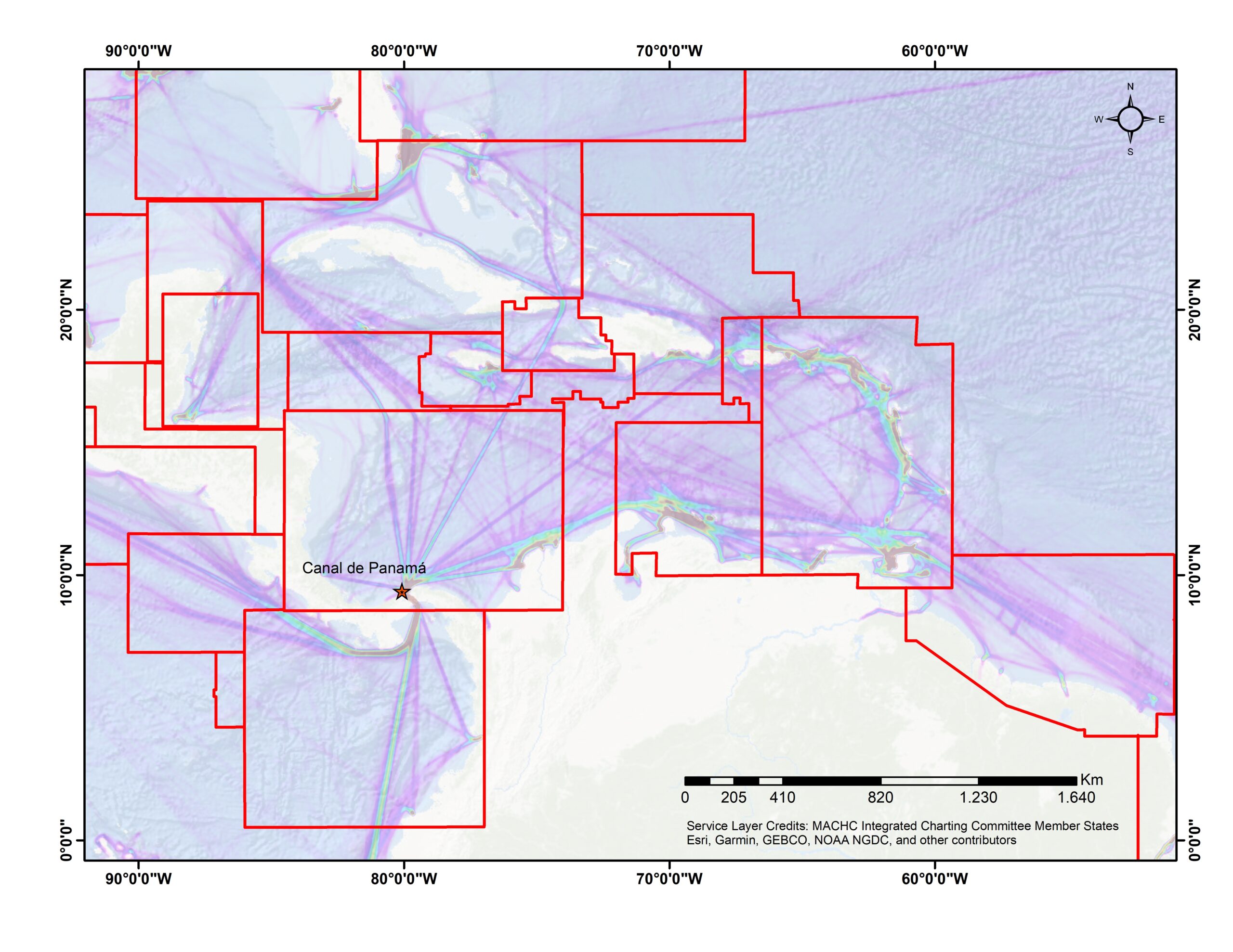
The proposed methodology for the standardization of ENC schemes in the Caribbean Sea was implemented because this region has several important characteristics that must be taken into account in the realization of a regional ENC scheme, is a semi-enclosed sea, there are several countries, both continental and insular, each with its own maritime territory and with different levels of cartographic capacity, which, depending on the level of maturity and cooperation between the MS makes it difficult to define the appropriate scheme for the region. The location of the Panama Canal, being one of the most important waterways (heatmap of the traffic density of vessels), with all navigationally significant changes being disseminated and published in national legislation affecting shipping and port regulations and for safe navigation. The Caribbean Sea is an interconnected point for various interregional and interoceanic trade routes. In 2022, according to inter-American development bank, reported that trade grown in Latin America and the Caribbean showed greater dynamism compared worldwide represented by 18.8 % (Giordano & Michalczewsky, 2023). The particular bathymetric and environmental characteristics, such as the presence of hurricanes during a certain time of the year.
The Caribbean Sea is part of the area of responsibility of the MACHC. The current ENC scheme for the region was defined based on the existing paper nautical chart scheme (MACHC-ECWG, 2003), in accordance with what was agreed during the fifth meeting of the MACHC in 2002. However, the analysis shows that the coverage between ENC and INT charts is not equivalent (Fig. 1). This indicates that some ENC producing agencies produced ENCs without reference to the INT paper chart scheme completely.
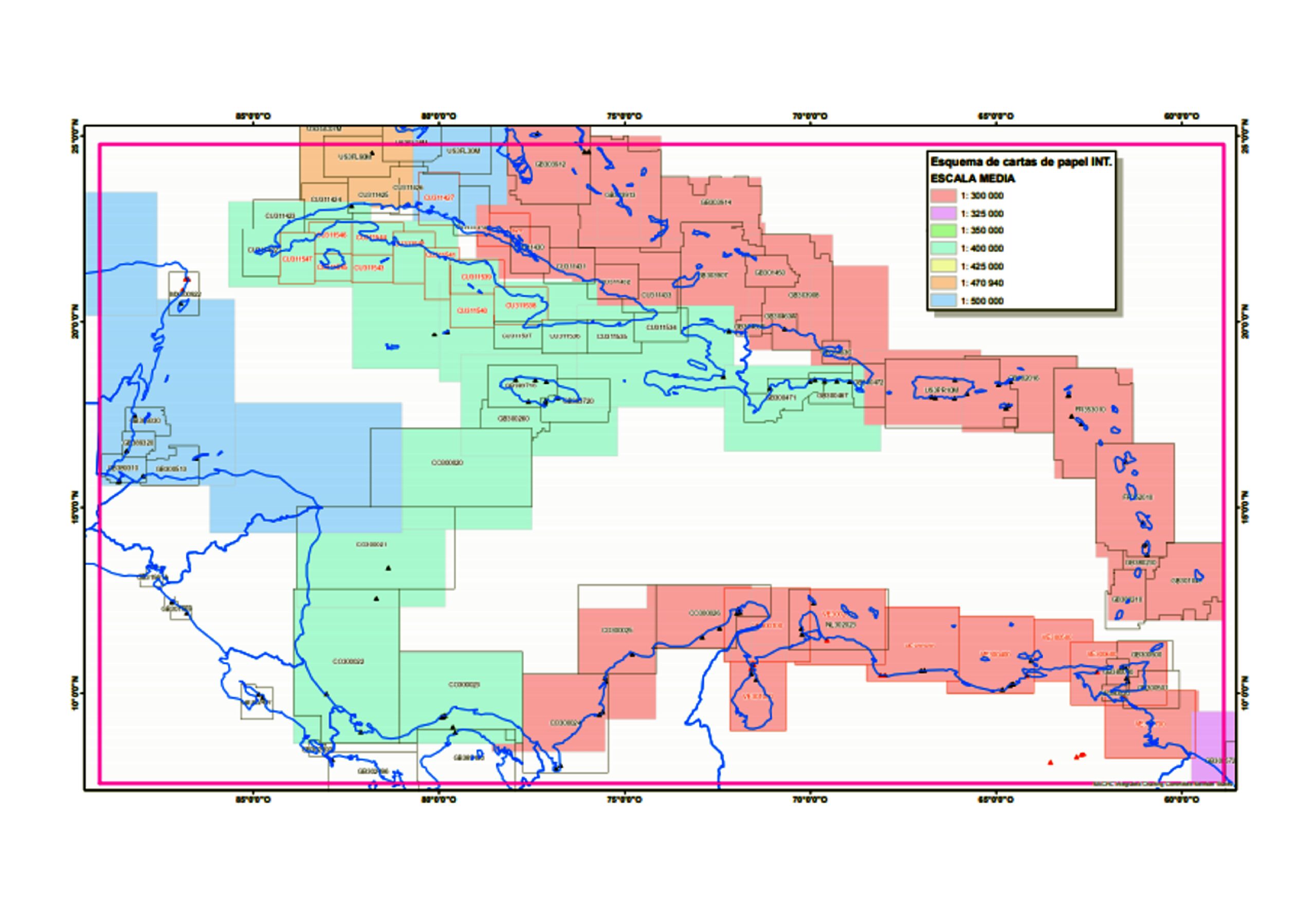
The evaluation of this scheme was carried out considering coverage, cell dimensions, layout design and scale bands of ENCs for navigational purposes. For this, the information available on the web portals of the RHC, Value Added Resellers (VARs), and the IHO catalog was obtained as a reference, whose information is provided by the Regional ENC Centers (RENCs), the Member States, and distribution agencies. The coverage of ENCs for the MACHC according to the different navigation purposes is displayed in Fig. 2, where the lack of standardization of the current scheme is observed.
2.1 Coverage and design
From a comparison of the current coverage of ENCs by navigational purpose and the international paper chart (INT) scheme for region B (Caribbean Sea) of the MACHC Integrated Chart Committee (MICC; MICC, 2013), approved by the IHO, it was possible to determine that the coverage of both products is not shown equivalent. This indicates that the ENC scheme for the region was made without reference to the existing INT paper chart scheme, in accordance with IHO guidelines.
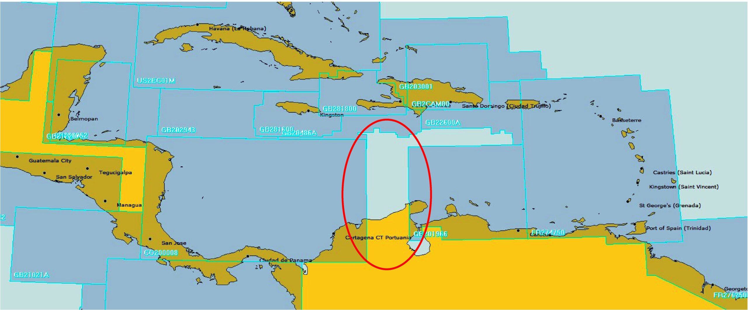
The detailed digital review of the current scheme showed the existence of a variety of ENC designs, gaps in coverage (limits between ENCs), irregular representation of the data, and that same navigational purpose for example ENCs have a range of different scales, for General navigation purposes GB281600 at 350,000, US2EC01M at 1.200,000, GB21218A at 700,000, and cases of reverse scale/ purpose overlap between producers of GB203768 and US3GC01M. Additionally, incomplete coverage was found in some areas of the Caribbean Sea (Fig. 3), which may be related to inequality in the cartographic capabilities of the countries that make up the region. However, some areas of the Caribbean Sea are covered by ENCs produced by some countries authorised under agreements with countries that have responsibility for maritime territory.
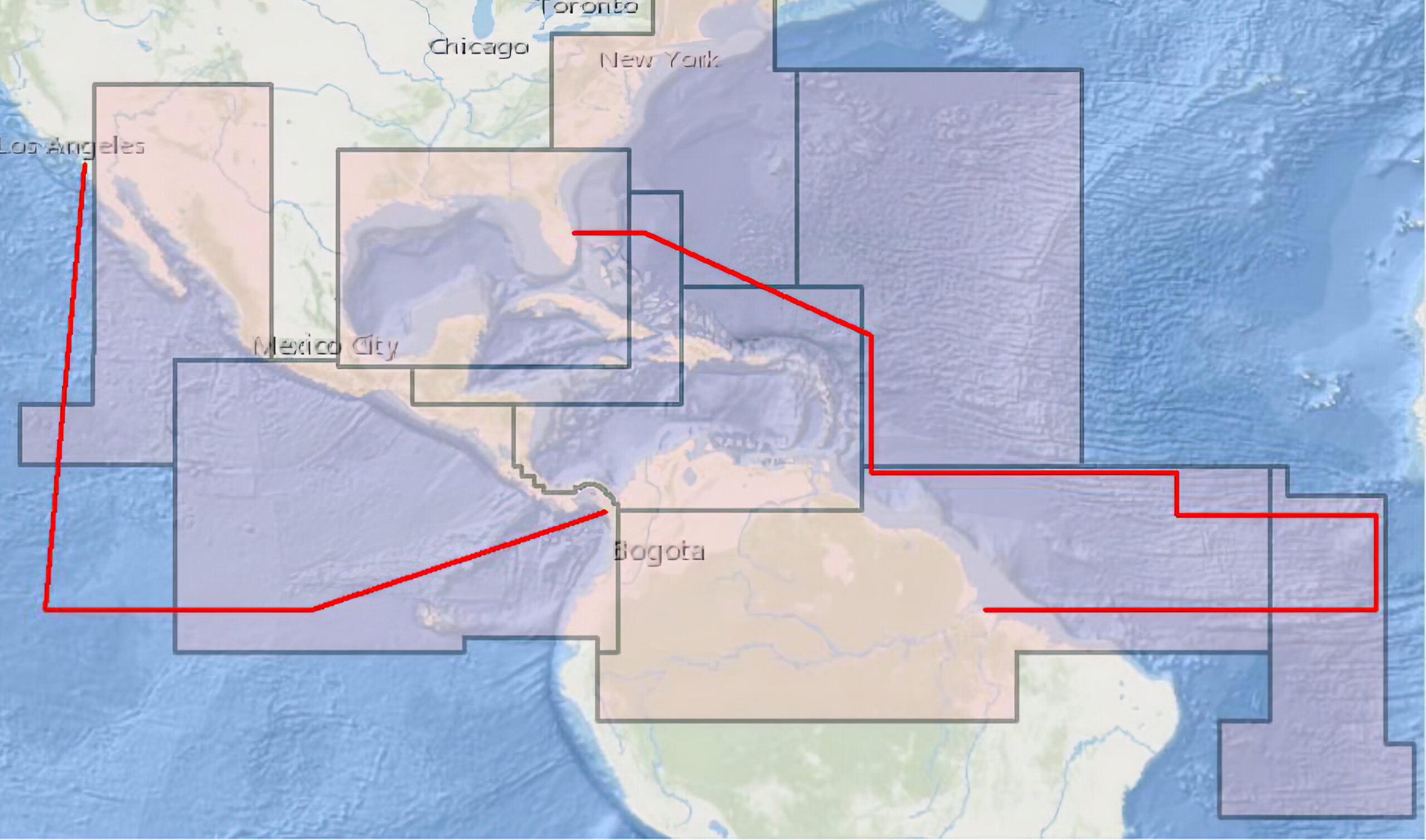
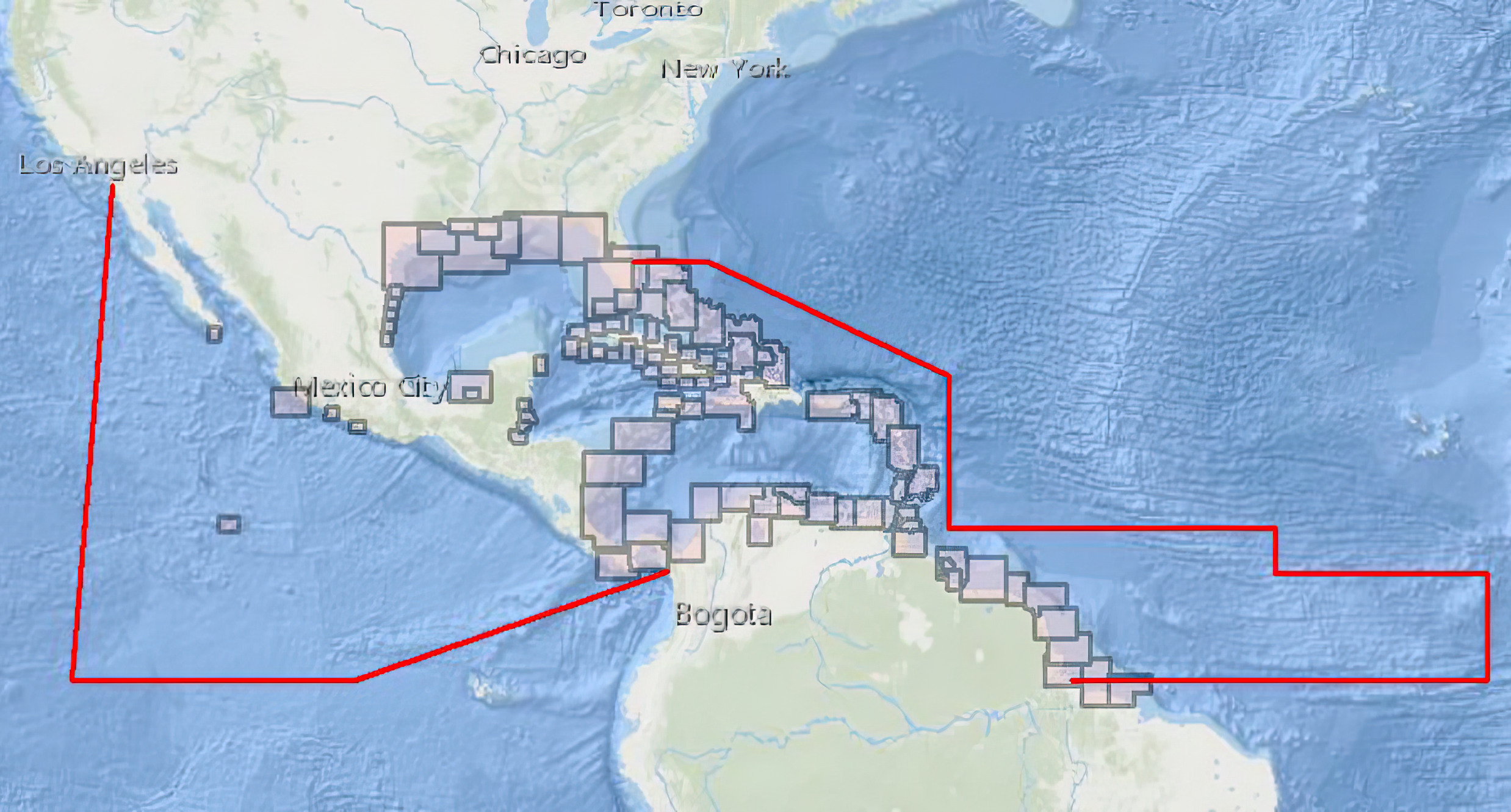
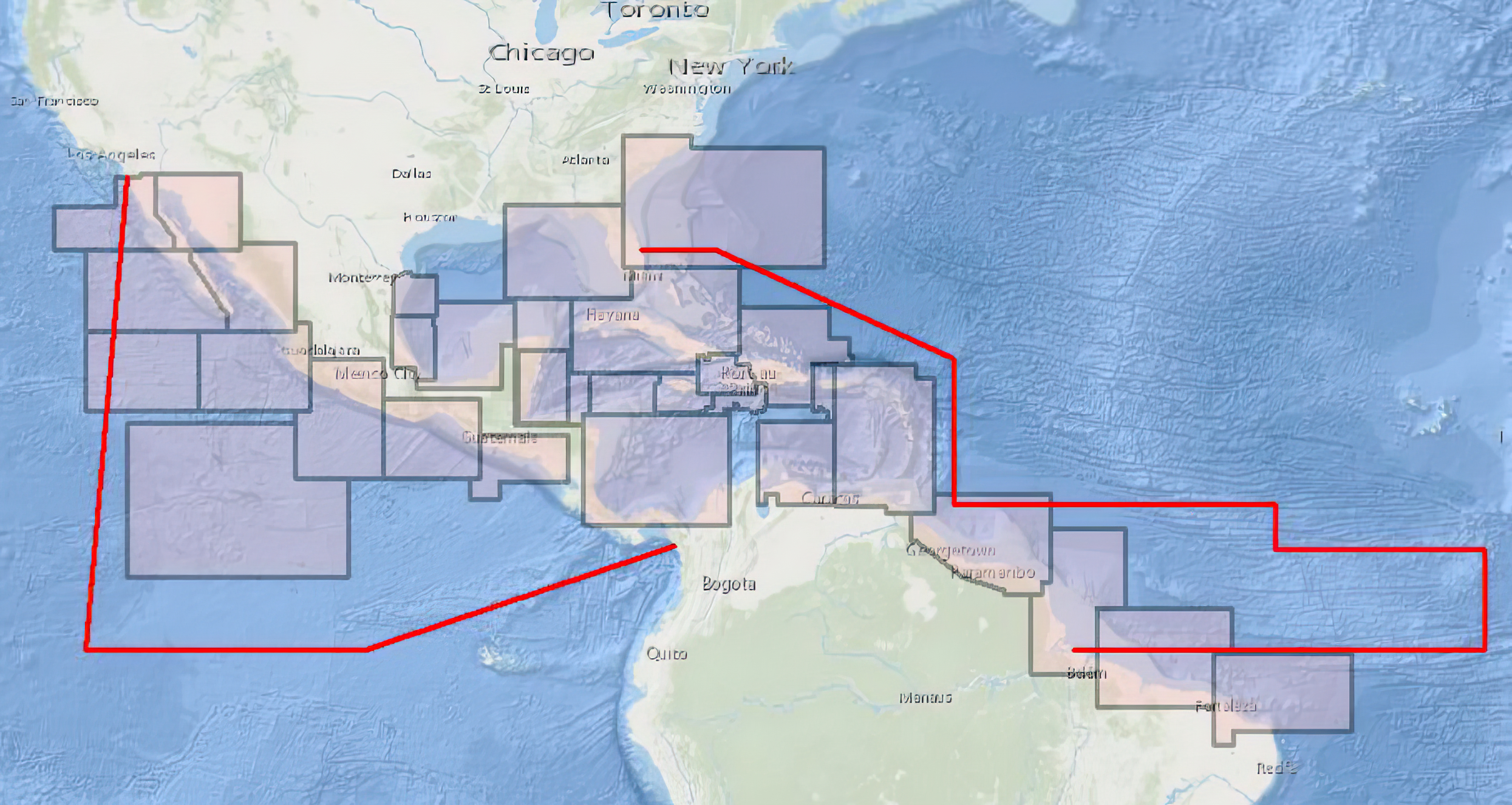
(a) Overview, (b) General and (c) Coastal; MACHC limits are showed a red line. Source: Information consulted in the MICC online catalog, December 2021.
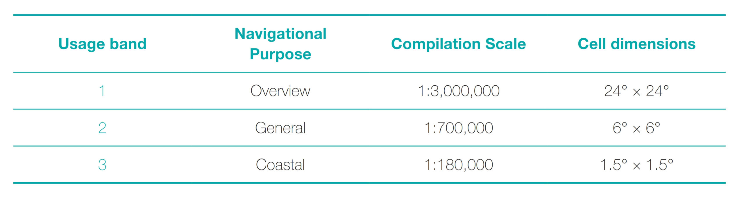
2.2 Scale ranges for navigational purposes
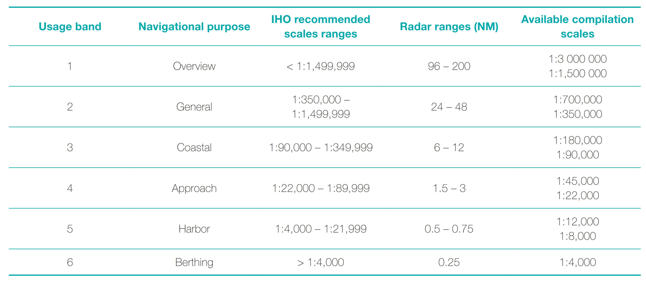
IHO publication S-57 (IHO, 2000) determines that ENC schemes should be organized according to navigational purposes (Table 1). Although some specifications are given for the ENCs, they guide but do not define the assignment of the scales in the ENC cells according to the six navigational purposes (IHO, 2018b). As a consequence, producers do not use a fixed scale for all cells, but rather adapt the compilation scale according to the navigational requirements of international shipping and the need to provide a coherent and logical scheme of charts for a route or for port entry (Jonas & Melles, 2003). The term Compilation Scale refers to optimum scale at which the compiling HO intends the ENC data to be displayed for the Navigational Purpose, while recognizing the user’s ability to modify the actual scale at which the ENC is viewed in the ECDIS (IHO, 2018b).
In Table 1, the column Available compilation scales refers to values normalized with respect to the scale in the radar range. Radar ranges are given in Nautical Miles (NM), indicating the location of an object or possible target within the system range (maximum miles) seen on the radar screen (Cerpa & Lorenzo, 2015).
In 2004, the IHO published Circular 047 which gave recommendations on the range of compilation scales for navigational purposes (Table 1), in order to improve scale consistency between ENCs (IHO, 2004b). Seeking to interrelate the compilation scales with the navigation purpose, the S-65 (IHO, 2017) standard was published, exhorting HOs to create ENCs with normalized compilation scales according to radar range. It should be noted that the HOs are autonomous in adopting and executing these recommendations. For example, the United States of America, considered that the recommended scales did not conform to the ENCs under their responsibility (Pharaoh, 2007; NOAA, 2017).
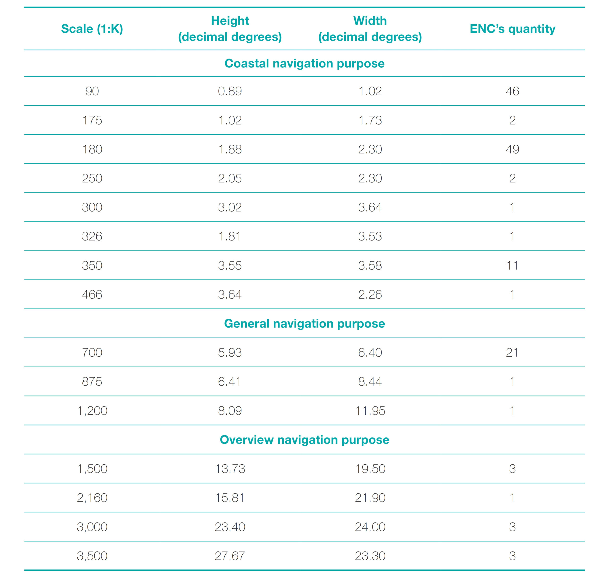
The above problem can be observed in the MACHC, where there are different scales and sizes for ENCs with the same navigational purpose (Table 2). This weakness generates the following difficulties. First, for the application of the minimal display attribute to objects by the end user. Second, it does not guarantee a complete display of data using ECDIS systems. Third, it does not adopt the recommendation of the available compilation scales per radar range (IHO, 2007).
Not assigning normalized compilation scale values with respect to the Radar range generates problems for the end user, since when viewing the ENCs in an ECDIS, coherence between the range of radar scales and the navigational purpose is not guaranteed. This can lead to confusion in data representation and control when applying attributes such as the minimum display scale (SCAMIN attribute; Duplancic, 2007).
Despite this, it is important to highlight that the MS of the MACHC recognize and are committed to the need to harmonize the coverage of ENCs and their scales, especially for the navigational purposes of Coastal, General, and Overview navigation, which are analyzed in this proposal (MACHC, 2019).
Taking into account the weaknesses indicated, it is considered necessary to establish a methodology to standardize the regional ENC schemes, which allows to improve the coverage, and unify the dimension and compilation scale by navigational purpose of the ENCs, in a coherent way for each RHC. The end user of an ENC displayed on the ECDIS will benefit the most from this standardization, obtaining harmonized coverage by navigational purpose, which guarantees safety when navigating in each of the RHC regions (Hippmann, 2012).
3 Methodological proposal for the standardization of the ENC scheme
In order to standardize the ENC scheme for Overview, General and Coastal navigational purposes, the current ENC schemes and ENCs of the different RHCs were consulted, seeking to formulate a proposal to unify specific criteria regarding the scale of compilation and the size of the cells for different navigational purposes. The foregoing seeks to obtain a scheme that guarantees complete and coherent coverage of ENCs in the regions.
From a SWOT analysis, it was found that the design and implementation of a grid scheme allows overcoming the following weaknesses that delimit the current schemes. First, gaps in coverage, due to differences in the level of hydrographic and cartographic capacity of the member states that make up the different CHRs, which represents a weakness due to the lack of information and full coverage with ENC. However, the need is supplied through another authorized producing country, which is autonomous in generating the product, defining the size, scale and purpose of the cell. Second, to avoid overlaps in coverage and data by growth of the schema without an organized way. Third, remove irregularly sized cells, with various compilation scales among ENCs for the same navigation purpose.
The regular grid system handles characteristics of the design that are listed below:
- Cell boundaries are generated from a starting point defined in this project, following the longitude and latitude lines consistently for the polygon.
- The value of latitude along a row is constant, so is the value of longitude with respect to the column. This system should be flexible for ENC for navigational purposes 4 and 5 adjusting to coastal geographic feature.
- Cells by navigational purpose have the same distances in latitude and longitude (fixed values in degrees).
- The sizes are standardized for navigational purposes defined for the RHC according to a basic statistical analysis.
- The organization of the bands of cells is progressive by use, that is, the larger-scale cells will be contained in the cells of the smaller-scale usage bands, sharing latitude and longitude limits. To improve user experience by allowing smooth transiting and transition from small to large ENCs for the end-User and allowing one more option to select the appropriate safety contour in coastal navigation.
- There is a limit to the number of cells in the subdivision of a smaller scale area.
- Geographic features and ports will be completely covered in a single cell or between several contiguous cells.
- According to the above, to implement a gridded ENC scheme it is necessary to define three aspects: depending on the navigational purpose: (i) define a scale and (ii) standard cell size, and for the scheme in general, and (iii) define the point of origin for the generation of ENCs. These aspects are analyzed below, as well as the proposed ENC nomenclature for a grid system.
3.1 Standardization of scales
It is suggested to establish for each RHC a single compilation scale for ENCs by navigational purpose, which takes into account the recommended RADAR range (Table 1) and regional characteristics. This considering that publication S-11 suggests the possibility of reaching a relationship between scales available for navigational purposes, however, this alignment in S-65 is not mandatory. For this, it is suggested to follow three steps.
First, analyze the ENCs published in the RHC, classifying them by navigational purpose and compilation scales (Table 2). It is recommended to consider all ENCs, including those that are not part of the RENC. This information can be found in the ENC database for RHCs, available on the IHO portal. Second, from the list of ENCs, the value of the compilation scales used in the ENCs for each of the navigation purposes will be taken into account in order to review and carry out a simple statistical process, where it allows obtaining the average, mode and median. Reviewing how adjusted they are with the scale according to the value per radar range and the navigation purpose all according to production. Third, the statistical results are compared with the normalized scales corresponding to the RADAR ranges (Table 1), determining the value closest to the average, as well as keep in mind the values obtained in the mode and median.
This methodology is applied with some examples below to show the ease of implementation. Four RHCs were selected and from the available ENC information, the average of the scale of their ENC was calculated according to the navigational purpose (Table 3). The results show the differences between the scales in all the navigational purposes analyzed, indicating the importance of respecting regional differences. These averages are useful for each RHC to define a single compilation scale per navigational purpose.
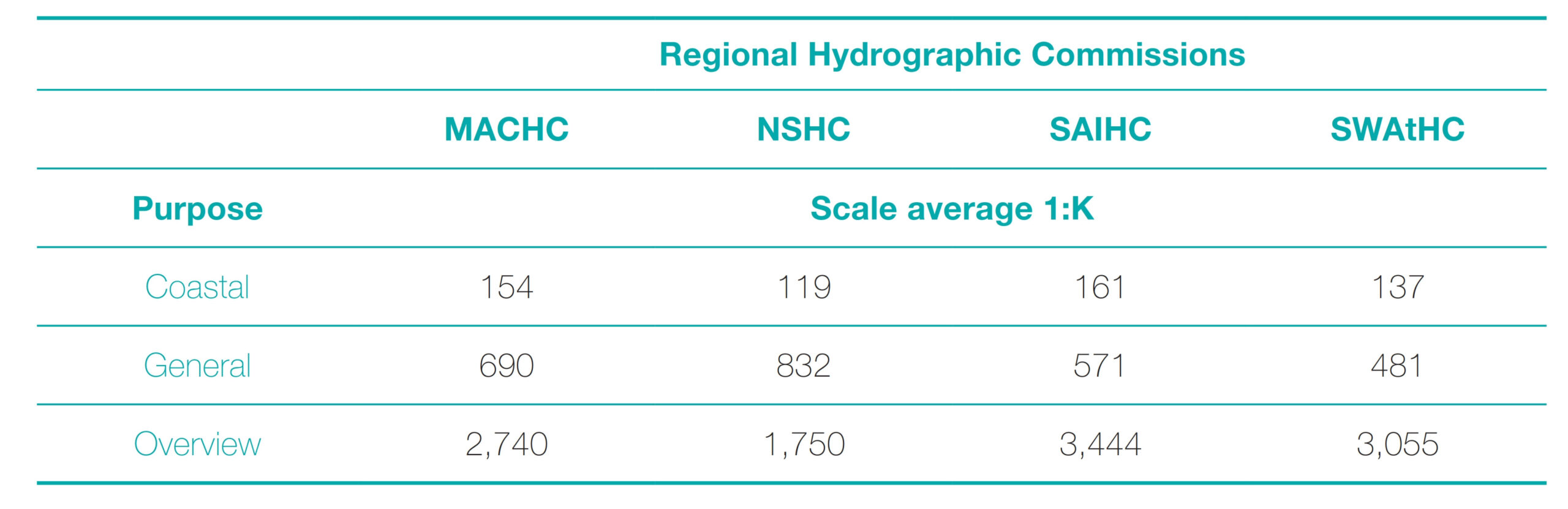
Due to the differences between the four RHC commissions in terms of coverage, area and scales, a scale close to RADAR is recommended for each RHC. The statistical analysis was used for the recommended scale as indicated by way of example through particular cases for the North Sea Hydrographic Commission (NSHC) and South West Atlantic Hydrographic Commission (SWAtHC). For the coastal purpose of the NSHC (199 ENCs) the scale average is ~120,000, therefore, when compared to the Available Compilation Scales (Table 1), it is 60,000 from 180,000 and 30,000 from 90,000; in this case, for the NSHC it is advisable to use the 90,000 scale. This result should be based on the estimation of the purpose of navigation and further user research. However, for this study it is based on the statistical procedure because the average scales are in accordance with published information. Similarly, for the purpose of Oceanic navigation, eight ENCs were analyzed, where the average scale was 1,750,000. When compared to the Available Compilation Scales (Table 1), they differ by 250,000 from 1,500,000 and 1,250,000 from 3,000,000. Due to this difference, it is suggested to use the 1,500,000 scale in this case based on the estimation of navigational purpose.
For the SWAtHC, 24 ENCs are reviewed for General purpose. The recommended scale is 1: 350,000 because the difference between the average value of 481,250 and the Available Compilation Scales is 131,250 with respect to the 1: 350,000 scale and is less than the 218,750 difference from the scale 1: 700,000.
In the case of the MACHC, the 108 ENCs were analyzed for the purpose of Coastal navigation (Table 3), and an average value of the scale of 1:154,000 was found. Given its proximity, the best scale is defined as 1:180,000, taking into account the Available compilation scales (Table 1). Additionally, the median and mode were analyzed, finding values of 180,000 in both cases. In the case of mode, this value was found in 49 of the 108 ENCs for this navigational purpose. These results coincide with the selection of the 1:180,000 scale selected.
For General purpose, it is recommended to use the scale 1:700,000, considering that the average scale 1:690,000 is closer to this value of Available Compilation Scales. This scale is also consistent with the median and mode values reaching the same value in 21 of the 29 ENCs. For the purpose of Ocean navigation, nine ENCs were analyzed and the scale 1:3,000,000 was selected as it is the closest scale to the average of 1:2,740,000. There is consistency with the results of the median (3,000,000) and with one of the two modes (3,000,000 and 3,500,000).
3.2 Cell size
Each hydrographic service has the faculty to decide how the ENC sizes are defined for their country. However, for a regional scheme it is necessary for the RHC to propose some limits based on a defined scheme for medium and small scales and in the case of medium and large-scale schemes for coverage of International Charts in their regions, seeking to improve the final product for the user, who on the same route can use ENCs produced by different countries. With the objective of eliminating irregular ENCs and giving greater coverage to the same compilation scale for navigational purposes, it is necessary to evaluate how many cells (regular and irregular shape) are needed to cover the same area that is covered with a paper chart of the INT scheme. These results are useful, because some countries adopted the INT scheme for the production of ENCs as an IHO recommendation.
The INT paper chart scheme corresponding to each RHC is a useful reference for defining the size of ENC coverage for Coastal, General and Overview navigation purposes. With this scheme, a compiled data source is available for the largest number of ENCs. However, it is important to remember that ENCs are not required to be equivalent to other products such as raster or paper charts.
Considering the above, in Fig. 4 indicated the proposal methodology to define the cell size at the regional level following workflow.
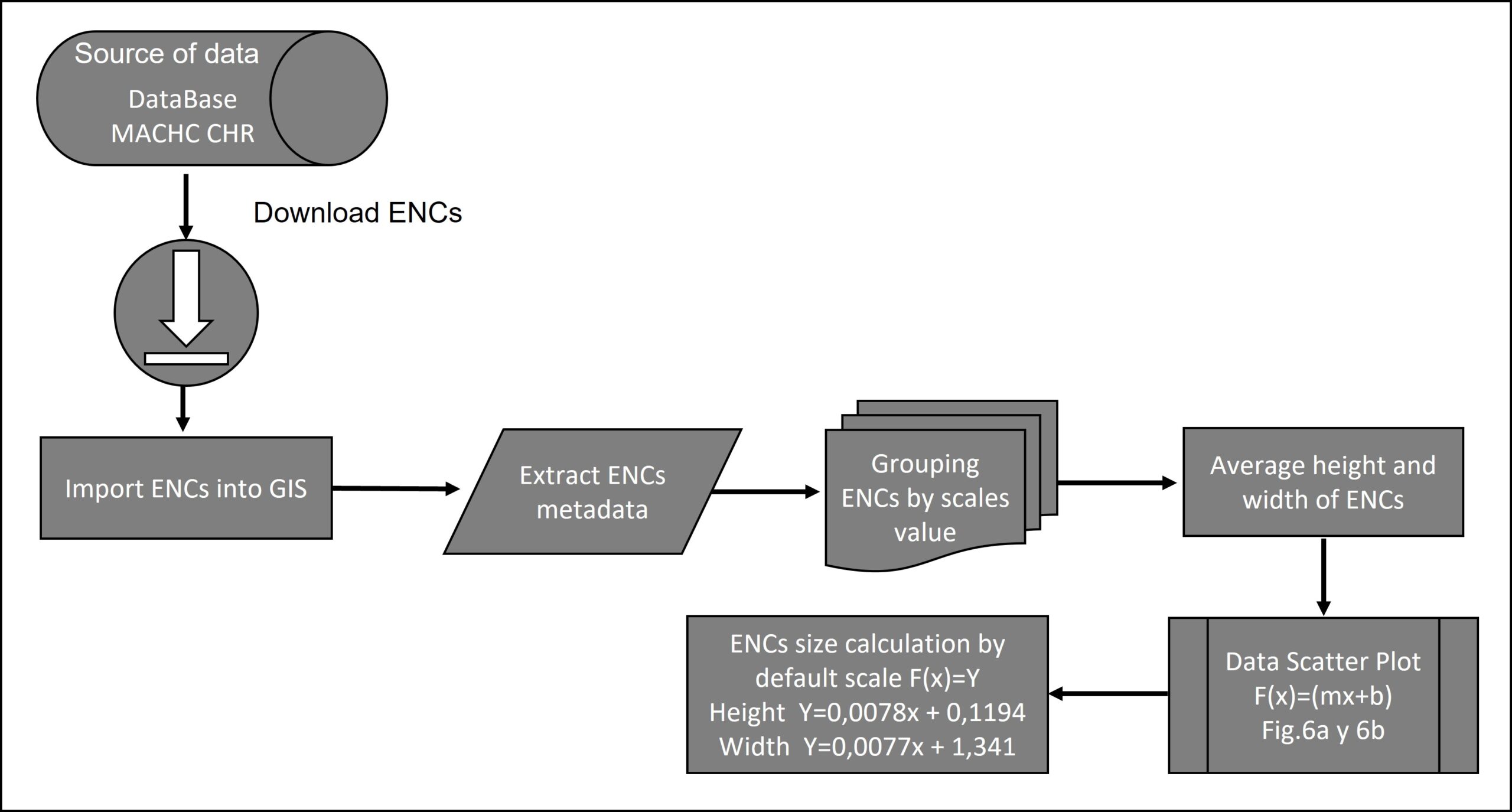
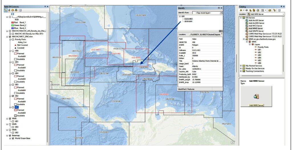
The methodology is applied to Caribbean Sea study area of the MACHC to illustrate the procedure. The polygons M_COVR catcov = 1 of the current ENCs were imported into a Geographic Information System (GIS) classifying them by navigational purpose. The coverages published by the IHO for the MACHC were used as a data source.
Given the availability of Web Map Service (WMS), connection was made in the GIS using the following URL: https://gis.charttools.noaa.gov/arcgis/services/MACHC/MICC_ENCview/MapServer/WmsServer?
Fig. 5 shows how to access the cells to obtain measurements and metadata of the ENCs.
The coordinates of the corners in each ENC are checked to obtain the height and width distances, with the difference of the values of height along the meridian and width along the parallel, all set to decimal degrees. Also, review the ENC’s attributes or metadata to create the relationship between the ENCs and their scale value.
The 146 ENCs were grouped according to their scale into 15 groups. For each of these scale groups, the average height and width is calculated, as indicated in Table 2. In this way it is possible to differentiate the three navigational purposes.
The relation of scale/height and scale/width values are represented in a scatterplot (Fig. 6). A straight line was fitted to these data by least squares, obtaining the corresponding equation, which was obtained to generate the values of adjustments to the selected scales for the regular grid system. In Fig. 6 there is a positive linear relationship, although some points corresponding to the width (Fig. 6b) move away from the straight line configured on the scales 1:466,000, 1:1,500,000 and larger.
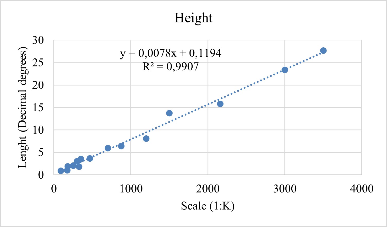
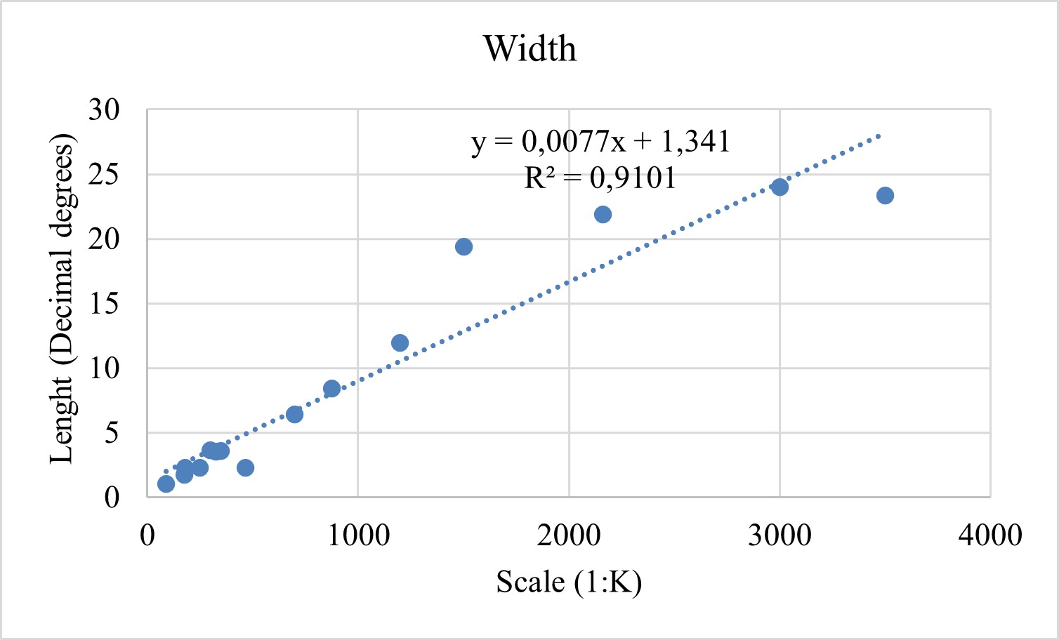
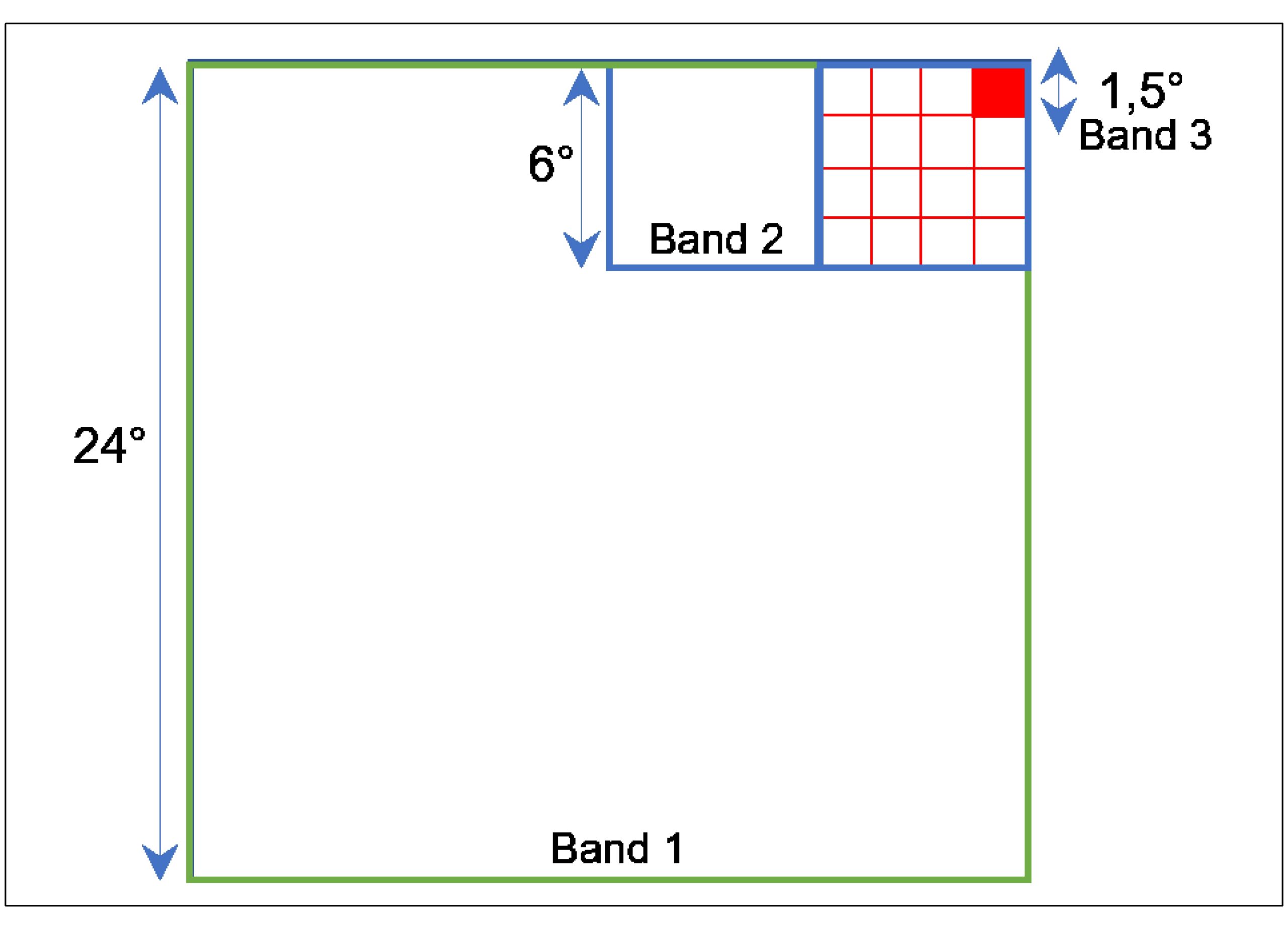
The statistical model is executed to estimate calculate the size of the cells in relation to the scale for the purpose of navigation. For example, if an ENC at a scale of 1:700,000 is wanted, then using the models these ENCs will have a height of 0.0078 · 700 + 0.1194 = 5.58 decimal degrees, and a width of 0.0077 · 700 + 1.341 = 6.73 decimal degrees. Rounding the values obtained from the ENC statistical model for each scale, seeking to generate a progressive grid that connects the limits of the different navigational scales. It must be taken into account that the size of the cell is a value given in degrees and must be an integer number the having the divisibility criteria with respect to the size of the minor scale, which will be simplified to generate the major scales allowing the exact number of dimensions of the cells. These values must be simplified to produce a grid with interlocking boundaries, and the heights and widths are doubled as the scales progress (Fig. 7).
It is to be considered that towards the poles the extension between longitudes of the ENCs is reduced in comparison with the extension between latitudes that remains constant, due to the convergence of the lines of longitude. That is, towards the poles, one degree of latitude represents a greater distance than one degree of longitude (NOAA, 2019). This effect is most noticeable in cells with latitudes greater than 48°.
The results obtained in the conditioned line were rounded, seeking that the dimensions of larger ENCs occur in multiples of ENCs with smaller dimensions, thus creating a progressive grid. For each scale, the same value is assigned for the height and width of the cell. For scale 1:3,000,000, the adjusted line value is 23.52° height and 24.41° wide, so for the MACHC a value of 24° was assigned for a regular grid. Similarly, the General purpose ENCs (1:700,000) were 6° and the Coastal purpose ENCs (1:180,000) were 1,5° (Table 4). Note that the compilation scales obtained in section 3.1 are used and that the cells with the highest dimension are multiples of the cells with the lowest dimension.
3.3 Defining the origin for the scheme design
Considering that the design of the proposed scheme is a gridded system, it is necessary to assign a point of origin, which indicates the limits in latitude and longitude from which the grid scheme is designed.
To assign this point of origin, it is suggested to take a point of regional interest, which can be determined by a port or, in the case of a gridded scheme to support the global coverage, a coordinate is estimated at the extreme point of the area (for example, to the southwest). This allows the coverage of the area and integrate separated spatial regions.
The cell that covers it is taken as the starting point and the necessary adjacent cells are selected considering in each of the polygons that represent them, the following: i) keep the established size, ii) add the cells adjacently in any of the senses, and iii) increase the number of polygons until adequate coverage of the area of interest is achieved. In this process, characteristics such as geographical accidents, depth areas indicated for each navigational purpose or criteria of the HO, which can generate a danger to navigation need to be covered.
The design can be achieved manually; however, it is suggested that it be done with the assistance of a grid-based algorithm that can be executed through a GIS. To use this software, it is required to have the height and width parameters of the cells or the number of columns and rows (Table 4) into which the determined area is divided. Having the grid in a GIS allows reviewing different schemes as the best point of origin is evaluated, whose selection has a subjective component.
The application of these criteria is made below for the MACHC in order to better explain the method ological proposal. The scheme design was worked using the Grid Layout algorithm incorporated in the ArcGIS Create Fishnet tool, defining the parameters (Fig. 8) in the geographic coordinate system, WGS-84 datum.
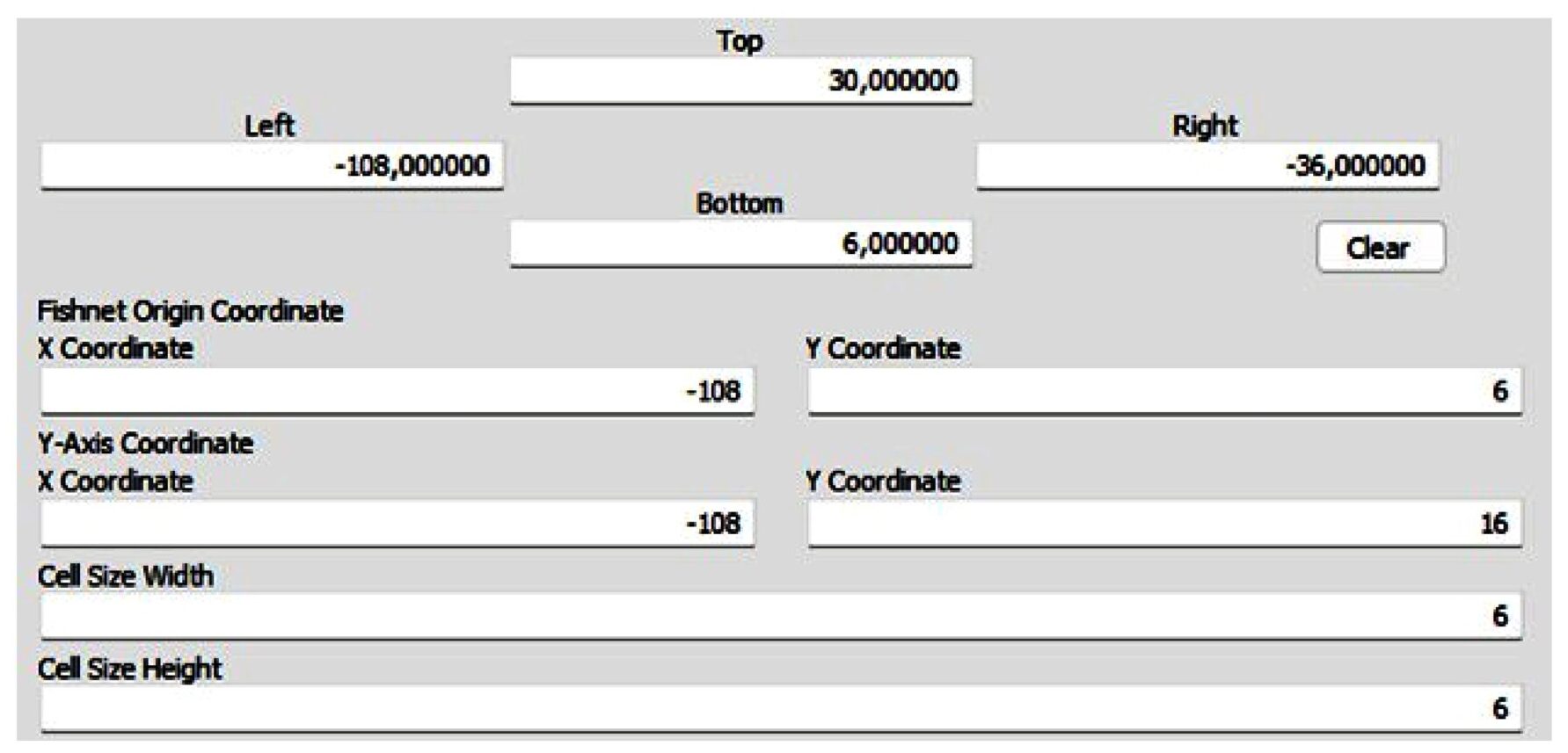
For the selection of the latitude of the point of origin, the Panama Canal was selected as the main point of convergence of the navigation routes in the Caribbean Sea, which also coincides with the southern limit of the study area. The coverage of the current ENCs was evaluated with respect to the complete coverage of this interoceanic port, assigning 6° N as the latitude of the point of origin (southern limit of the scheme), in such a way that the canal will be at the center of the new of the General navigation purpose ENCs (Fig. 9).
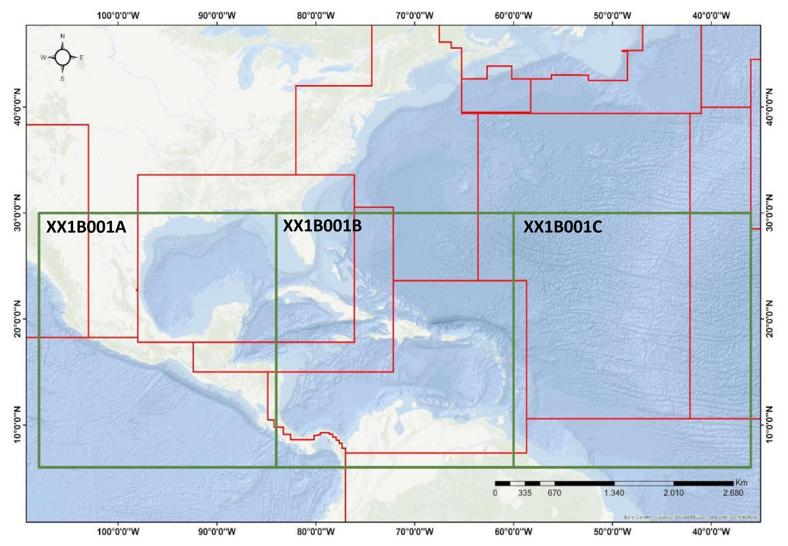
For the selection of the longitudinal limit of the scheme, priority was given to maintaining the uniformity of the grid of ENCs for Overview navigation purposes, as they have the largest area (24° × 24°). In order to guarantee coverage of these ENCs, the longitude of the point of origin is established as 108° W (western limit of the scheme), which is outside the Caribbean Sea area (Fig. 10). Additionally, for the selection of this limit, it was decided that the Panama Canal should not be close to the limit between ENCs of General navigation purpose (Fig. 11).
It is pertinent to clarify that this limit does not force the General and Coastal chart scheme to start at this longitude, however, it is necessary that the limits of all charts, regardless of their navigational purpose, coincide.
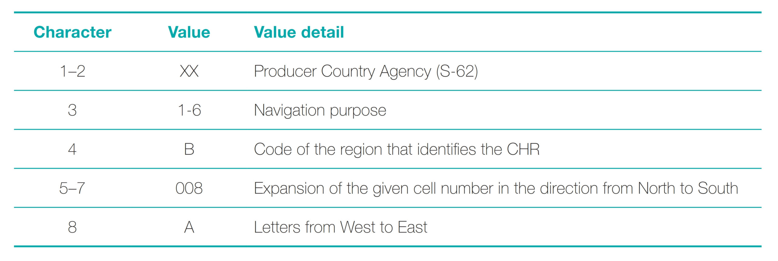
3.4 Nomenclature for ENCs
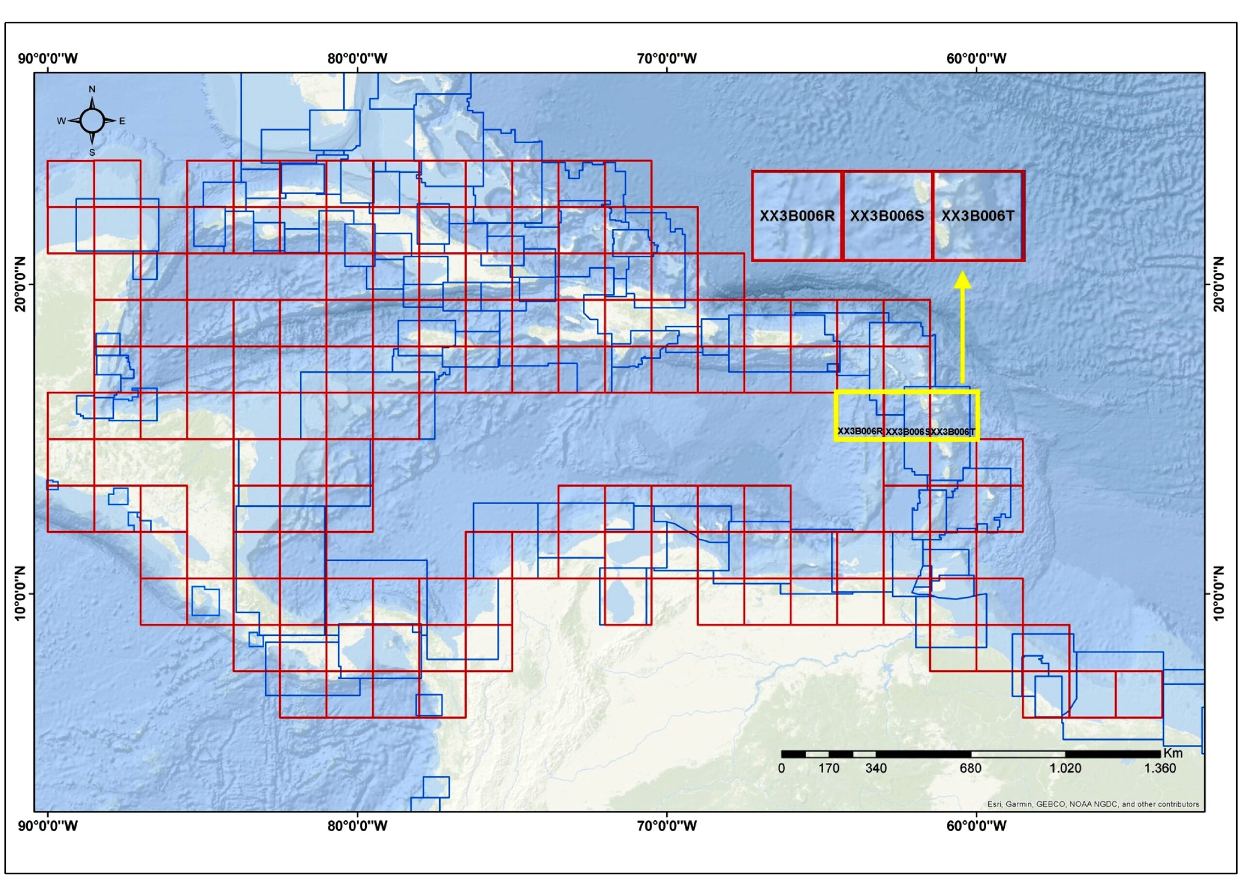
To assign the nomenclature of the ENC in the grid system, the structure standardized by the IHO with the eight characters for the identification of the ENCs. The characters 1, 2 and 3 are mandatory with respect to the S-57 naming convention the rest can be given free of choice (Table 5). The nomenclature depends on each navigational purpose (third character). Character 4 will be occupied with the letter that identifies the Regional Hydrographic Commission according to the regions defined by the IHO. The next three characters describe the ENC number, which are defined by the position of the polygon with respect to its position from North to South. The last character will complete the identification of the cell by adding a letter that starts the position from West to East.
In the case of the MACHC, the letter B will be maintained as the fourth character in the nomenclature of the gridded scheme. The protection of the last four characters of the nomenclature starts from the ENC located in the northernmost and westernmost position of the study area, for each of the three proposed navigation purposes (Fig. 11 and 13).
For the design of the schemes, political maritime borders are not taken into account. Therefore, there will be cells that will compromise jurisdictional waters of one or more countries. In this case, for the creation of the ENCs it is necessary to coordinate between HOs the divisions of the cell area for their creation, if the HOs are willing to cooperate in this manner. However, it is recommended that each ENC in a grid scheme have a single producing country, which is indicated with the production agency code (first two characters). This is an advantage of the grid system, since it guarantees that the same area is not contained in different cells, for the same navigational purpose. To achieve this, it is necessary to promote technical agreements or memorandums of understanding between neighboring countries, in which the cartographic limits are agreed upon, as there are agreements between some countries in the region.
To address the national maritime boundary and ensure comprehensive coverage, a potential approach involves adjusting the origin point of each country’s grid in the horizontal axis. This adjustment will make an overlap of ENCs extent across the boundary between the two countries. This adjustment will specifically involve manipulating the M_COVR object ensuring that it is extend beyond the maritime boundary is encoded as no coverage is available to avoid data discrepancies.
4 Proposed grid ENC scheme for the Caribbean Sea
In this section, the methodology proposed in Section 3 is applied to establish the grid scheme in the Caribbean Sea, which is part of the area of responsibility of the MACHC. The implementation of the scheme starts from the decisions made regarding the standardization of the chart scales, cell size, and the point of origin of the scheme. MS see the need for a major change, provided that the different HOs apply the agreed standards uniformly. The constraints will be in terms of human resources, time and cost, but the challenge is to reach agreements between neighbouring countries for implementation. In order to harmonize the coverage of ENCs in the MACHC, it is necessary to break the practice of maintaining the limits of paper charts in ENCs (IHO, 2020), thus making it possible to implement a grid scheme.
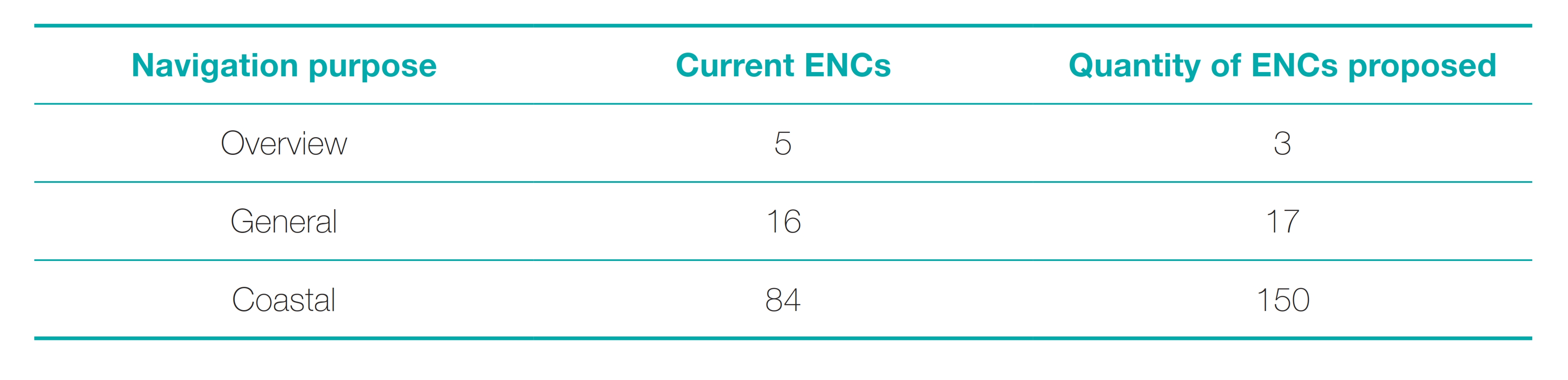
4.1 Results of Overview Navigation
Based on the size defined for the cells in the purpose of Overview navigation (Table 4), and using the coordinate 06° N , 108° W (southwest corner) as origin, it was possible to cover the work area with three adjacent cells of 24° × 24° for Overview purpose. This scheme eliminates data duplication and avoid gaps between adjacent ENCs (Fig. 10).
According to the MICC web catalog, currently the study area is covered by five ENCs with different scales, designs, and dimensions. With the proposed design, the area of the Caribbean Sea would be covered with three cells. It provides uniformity and consistency in coverage, generating confidence to the end user when viewing the ENCs in an ECDIS.
There will be cells that compromise jurisdictional waters of one or more countries. In the case of overview cells that have sea in the Caribbean and the Pacific, it is necessary to make the divisions of the cell area to be completed by different producing countries, which will be differentiated by the code of the producing agency (S-62). In order to achieve consistent, adjacent cells at the data level, the node coordinates should be in tenths of a degree to eight decimal places, to eliminate the discrepancy between objects at the common boundary. Between cells of the same navigational purpose there should be no tolerance in horizontal consistency.
In order to maintain coherence across national or regional borders, it is necessary to reach a consensus among the producers of ENCs in the RHC for the preservation of responsibilities with the intention of navigation purposes, compilation scales and the use of the SCAMIN.
4.2 Results of General Navigation
Bearing in mind that the grid system has the same point of origin for the design of the cells progressively, the cells of the Oceanic purpose are selected, that is, 24° × 24°, dividing these into 6° × 6° cells, size assigned for General purpose (Table 4).
The parameters were defined using the GIS tool, generating a grid with 48 cells, of which exclusively those covering the study area were selected for this research (Fig. 11). Note that the general navigation ENC scheme should not start at the western limit established for overview charts. Nevertheless, their limits are guaranteed to coincide (for example, 84° W and 60° W).
For this region of the MACHC, current ENCs show incomplete coverage for General navigation purposes. For example, in the area between Venezuela and Colombia, a coverage gap is observed. This situation arises due to the lack of a regional ENC scheme in the area, there is a cell produced by another HO (UKHO) that cooperated with the state (IHO, 2014), however, it is not designed with consideration of the adjacent national scheme.
The study area is currently covered by 16 ENCs with various scales, cell designs, and irregular data representation. To achieve consistent coverage for this navigation purpose, 17 cells with the dimensions of 6° × 6° will be designed. Based on current production considering as reference ENC overview, with these uniform ENCs control over the size of the ENC file is improved. This allows a better handling of objects, even in sectors where the polygon covers a greater proportion of land than the maritime part, facilitating its maintenance due to updates and operability in ECDIS. Additionally, it offers a regular nomenclature system that facilitates the identification of ENCs.
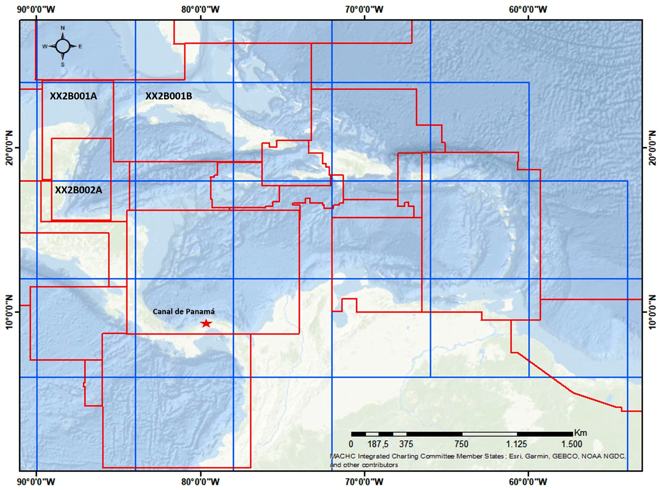
As example, to optimize the current scheme, in a flexible manner the point of origin could be adjusted to the north at latitude 9° 00’ 00 N, where for the distribution of the grid as like Fig. 12. Also, with the objective of avoiding the creation of ENCs in areas where the cells predominantly cover land areas representing approximately 90 % of their overall coverage. In these cases, it is proposed to make the limit of the adjacent cell more flexible by expanding it to cover the coastline.
The hatched zone shows that the data fraction is necessary and is linked to the adjacent ENC, in these cases because data exists suitable can be extended.
4.3 Results of Coastal navigation
A cell layout that completely covers the region of interest at this scale is recommended. However, it is not necessary to produce all ENCs that cover the area, but only those ENCs that cover areas that are of importance to shipping lanes or represent a hazard to the safety of ships. The definition of which ENCs and which country produces them are issues to be discussed within each RHC.
To achieve consistent coverage, based on nautical criteria, the layers with information on the coastline and bathymetric contours were activated as a preventive and safety measure, using the 50-meter depth contour suggested in the standard series of contours for nautical charts (IHO, 2021). Regarding the distance between the port and the edge of the cell, this aspect becomes irrelevant due to the continuity and adjacency between the cells.
According to the analysis carried out, the study area would need to produce 150 cells of the 288 for the region (Fig. 13). Compared with the 84 existing in this area of the MACHC, the increase in cells is significant, but it will guarantee coverage of a complete area and in an organized manner; preventing countries from making two or more ENCs for the representation of the same area.
As examples: according to reports annuals of WENDWG (2019) small overlap between two Venezuela cells VE300600 and VE300500. In 2020, PA3AM929 and CO300023; and MX402321 MX402314. In 2022, during the WEND meeting, ICENC listed overlaps, especially between ENCs that require actions by producers regarding to new cells about the representation of the same area, VE300700 and GB300501, VE300600 and GB300500, VE300600 and GB380040, VE300200VE300100, and VE300200 – NL302023 (IC-ENC, 2022).
Based on the three navigation purposes analyzed in this work, the proposed scheme increases the number of ENCs to be produced by 61 % when compared to the number of current ENCs in distribution (Table 6). Most of this increase is due to the fact that for the purpose of Coastal navigation it is necessary to generate cells in areas that cover islands and minimum depths of 10 to 50 meters, which were not contemplated in the current scheme.
In the grid system, high percentages of land greater than 50 % should be avoided as much as possible. It is recommended to capture only objects that are considered striking and represented on the ENC scale. This can also lead to problems, as geographic features won’t follow regular grid schemes. It must be ensured that the gridded scheme will be used properly. For example, to the schwedish scheme where specific usage two ENCs have only very little data coverage (catcov = 1) and most of the cell is (catcov = 2) just to fill the grid. ECDIS will always select such charts in while route check.
In the Coastal navigational purpose, the current cells present inconsistencies regarding the area of addictive depth, where, for example, an ENC from Venezuela represents an area with depths of 20 m to 200 m, while an ENC from Colombia shows an area with depths of 20 m to 200 m adjacent to an area with a depth range of 50 m to 100 m. This type of error is the cause of the inconsistent ECDIS display under certain configurations, showing the two adjacent areas in different shades of blue.
To ensure “integrity” between different ENCs with the same navigational purpose, it is necessary to share bathymetric datasets between ENCs compiler agencies and to standardize compilation techniques.
5 Summary and final remarks
A regular grid scheme for ENCs is proposed that covers the purposes of Overview, General, and Coastal navigation, providing uniform and quality coverage of the study area to the end user. The methodological proposal of this scheme can be applied to many regions. In this work, to explain the methodology, the scheme is implemented for the Caribbean Sea, an area corresponding to the MACHC. It is expected that this proposal will serve as an-input to discuss in the RHCs the benefits of establishing gridded cartographic schemes for ENCs.
The importance and potential benefits of applying the gridded ENC scheme in the Caribbean Sea is that it allows the generation of seamless coverage while reducing the problem of spatial overlaps between ENCs. Furthermore, that the scheme is a sufficient solution during the upcoming parallel production of ENCs S-57 and S-101, as it allows for a pre-assessment of the data improving the quality of the products, considering that 15 scale values between Overview, General and Coastal are used in the ENCs.
The expected impact on the safety of navigation is to increase user confidence through uniform and quality coverage. It is recommended that neighbouring countries establish, through agreements or memoranda of understanding between producer countries, rules for joint work, facilitating the publication of data from one country in the cells of another producer country. The basis of the cartographic work rests on the bathymetric surveys, which must always comply with IHO standards, ensuring that the information presented in the ENCs is adequate.
The implementation process involves challenges and constraints related to costs, resources and coordination between ENC producing countries. Considering this possibility of benefits, that these results can have an influence on electronic cartography worldwide.
Due to the lack of creation of regional schemes at RHCs, the characteristics of current ENCs vary significantly from one region to another (IHO, 2019). The standardization of regional cartographic schemes seeks the uniformity and consistency of ENCs, which improves safety during navigation using an ECDIS.
This proposal is aligned with the ordinances of the IHO WENDWG, who ensure that they provide maritime safety in compliance with the WEND principles and must develop proposals to produce ENCs ensuring that they are uniform, have quality and there is consistency in the data (IHO, 2018d). During the 10th meeting of the ENC Database Working Group (IC-ENC, 2020), one of the two Regional Centers for Global Validation and Distribution, reported the update on the status of ENCs regarding the overlap of the data, including cases of unwanted situations in the MACHC in border areas, even between cells of the same producer country.
Faced with the interest of activating the discussion on the coverage of ENCs in the MACHC, as part of the preliminary development of this research, Colombia presented evidence of the weaknesses and strengths related to the designs of ENCs during the 20th meeting of the MACHC in 2019, emphasizing what was found for the area of the commission (MACHC, 2019). As a result of this presentation, the member states recognized the need to rescheme ENC coverage by approving the creation of the Sub-Working Group for Regional ENC Schemes for the MACHC MRES. During the 21st meeting in December 2020, the MACHC supported the advances of the MRES subgroup and the approach of a grid proposal to be refined by the MICC subgroup starting with the purpose of Ocean navigation (MACHC, 2020).
The comparison of the proposed grid scheme with the distribution of the current ENCs was presented to the 22nd meeting of the MACHC held virtually in December 2021, in order to analyze and discuss the advantages and necessary modifications for its implementation (Fig. 10 and 11). This information is appropriate for the WEND group seeking to harmonize ENC schemes worldwide (MACHC, 2021).
The implementation of gridded scheme would generate limitations for ENC-producing countries, such as the cost-benefit ratio of making this change. The implications of human resources, time, costs and capacities required to carry out the implementation must be analyzed.
In this study, an academic proposal of the ENC scheme for the MACHC is made, which can serve as an-input for the discussion within this RHC. An alternative is to evaluate the convenience of the proposed grid system, where aspects such as the standardization of scales, cell size, definition of origin, among others, can be discussed. Once the update of the cartographic scheme is agreed, other aspects should be discussed, such as cell-producing countries, implementation priorities, transition process between the previous scheme and the current one, ENC update periods, among others. Until the approval and implementation, it is recommended to continue with other activities such as establishing technical agreements, in which cartographic limits are defined and surveys are arranged in areas of common interest.
6 Conclusion
The analysis of the current ENC scheme revealed shortcomings that affect the safety of navigation and therefore need to be improved. The main problems identified were that the schemes are not designed in a standard way for the CHR, irregular cell sizes and application of scales different from those recommended by IHO for navigation purposes.
Also detected horizontal inconsistencies in linear and area features across ENC limits can undermine user confidence in ENCs by showing discrepancies of lines and colours, due to lack of data integrity between ENCs. Other, is incomplete data visualisation due to the application of different scale values of SCAMIN attribute between ENCs.
The contribution of the application of the cell scheme is that the design should avoid overlaps and gaps in coverage for the same navigation purpose, allowing for greater consistency between products, increasing the confidence of navigators and optimising the performance and use of ECDIS.
In addition, the process allows the ENC content to be updated to create consistency in scale and content. By changing the data boundaries, it is the perfect opportunity to identify inconsistencies in the new gridded boundaries and resolve them, harmonising the dataset.
The implications of the proposed scheme on the regional distribution of ENCs is that the grid can be applied to all scales and scale bands, optimising route planning in a comprehensive and progressive manner. The design conforms to international IHO standards and WEND principles to ensure uniformity and high quality of ENCs.
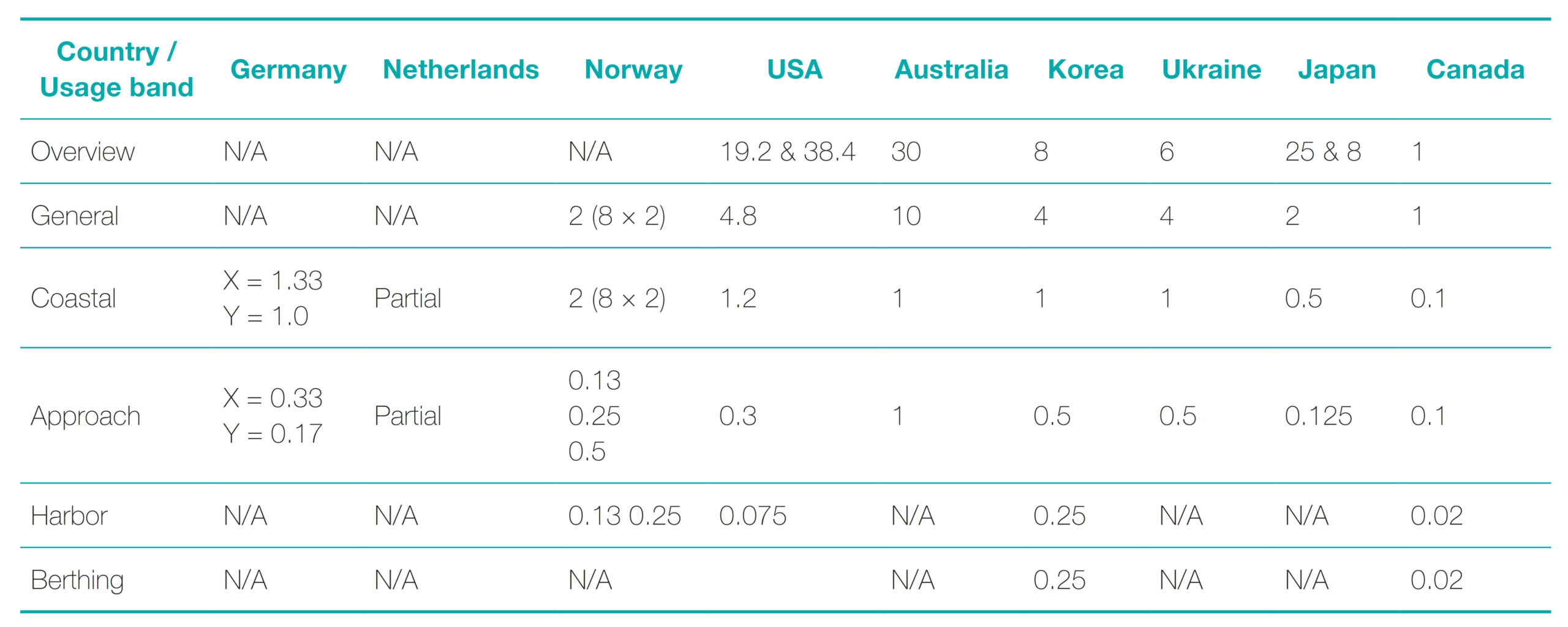
Currently, some countries are analyzing how to improve the coverage of their ENCs, evaluating the convenience of migrating to a regular grid system. Several countries have independently defined the size of their ENCs by navigational purpose (Table 7). This indicates how the size of the ENCs in each country is free, without there being a clear indication or restriction by the IHO in this regard, which affects the uniform coverage at the regional level of interest for the RHCs. An additional problem is that the specific cell size is not linked to a scale, an aspect that is contemplated in the methodological proposal of this work.
The design of a regular grid system like the one proposed is considered ideal for the MACHC. However, for a seamless global scheme, it is necessary for the IHO to approve the scales, cells sizes for different navigational purposes and the grid origin. These aspects should be agreed by the WENDWG to avoid transferring the problems of the past to the new production model under Universal Hydrographic Data S-100 including the S-101 standard (IHO, 2022).
Generate discussion spaces that lead to the establishment of common ENC grid schemes at RHC level standardized for Overview, Coastal and General navigation purposes, so that these are approved and adopted in order to guarantee consistent coverage to the end user, avoiding the continuation of independent ENC production. It is important that the schemes that are established are properly documented, with methodologies and examples of implementation.
References
Cerpa, A. and Lorenzo, J. (2015). Introduction to RADAR and ARPA systems. http://riull.ull.es/xmlui/handle/915/6842 (accessed 11 December 2022).
Duplancic, T. (2007). Specificity of ENC Data Representation on an Archipelagic Sea Area – Example of the East Coast of the Middle Adriatic Sea Area. International Journal on Marine Navigation and Safety of Sea Transportation TransNav, 1(4), 396–398.
Giordano, P. and Michalczewsky, K. (2023). Trade Trend Estimates Latin America and the Caribbean. 2023 ed., IDB. https://doi. org/http://dx.doi.org/10.18235/0004659
Hippmann, F. (2012). Production and Validation Solutions for Improving ENC Consistency. The International Hydrographic Review, 7, 33–41.
IC-ENC (2017). 7th WENDWG Meeting, IC-ENC’s Overlapping Data Policy & Reporting. https://iho.int/mtg_docs/com_wg/ WEND/WENDWG7/WENDWG7-04.1B1-IC-ENC%27s%20Overlapping%20Data%20Policy%20&%20Reporting.pdf (accessed 14 September 2023).
IC-ENC (2020). 10th WENDWG Meeting, IC-ENC’s Overlapping Data Reporting and Analysis. https://iho.int/uploads/user/Inter-Regional%20Coordination/WEND-WG/Joint%20RENC%20 and%20WENDWG10/WENDWG10_2020_06.1C_EN_IC-ENC_ Overlapping%20Data%20Reporting%20and%20Analysis%20FINAL.pdf (accessed 4 May 2023).
IC-ENC (2022). Report on Harmonization and Overlapping Issues (IC-ENC RHCs Overlap Reports). 12th Worldwide ENC Database Working Group (WENDWG) Meeting, Monaco. https://iho. int/uploads/user/Inter-Regional%20Coordination/WEND-WG/ WENDWG12/RHCs_IC-ENC_overlap_reports.zip (accessed 14 September 2023).
IC-ENC (2023). Technical Conference 23_1 Meeting Report – FINAL. Radisson Blu Astrid, Antwerp, Belgium.
IHO (2000). IHO Transfer Standard for Digital Hydrographic Data.
IHO Publication S-57, Edition 3.1. International Hydrographic Organization, Monaco.
IHO (2004a). Improving ENC Consistency. Circular Letter 47 (Annex B), International Hydrographic Organization, Monaco. https://legacy.iho.int/mtg_docs/circular_letters/english/2004/Cl47e.pdf (accessed 4 May 2023).
IHO (2004b). Recommendation for Consistent ENC Data Encoding. Circular Letter 47 (Annex A), International Hydrographic Organization, Monaco. https://legacy.iho.int/mtg_docs/circular_letters/english/2004/Cl47e.pdf (accessed 4 May 2023).
IHO (2007). ENC Consistency S-65. Circular Letter 108, International Hydrographic Organization, Monaco. https://www.yumpu.com/en/document/read/4403646/cl108-iho (accessed 4 May 2023).
IHO (2014). Guidelines for the implementation of WEND principles. https://iho.int/uploads/user/Inter-Regional%20Coordination/ WEND-WG/MISC/Guidelines_en_June_2014.pdf (accessed 4 May 2023).
IHO (2017). Electronic Navigational Charts (ENCs) “Production, Maintenance and Distribution Guidance”. IHO Publication S-65, Edition 2.1.0. International Hydrographic Organization, Monaco. IHO (2018a). Adoption of an IHO resolution on the elimination of overlapping ENC data in areas of demonstrable risk to the safety of navigation. Circular Letter 19/2018, International Hydrographic Organization, Monaco. https://iho.int/uploads/user/Inter-Regional%20Coordination/WEND-WG/Joint%20RENC%20 and%20WENDWG9/CL19.pdf (accessed 27 September 2023).
IHO (2018b). Guidance for the Preparation and Maintenance of International (INT) Chart and ENC Schemes. IHO Publication S-11, Edition 3.1.0. International Hydrographic Organization, Monaco.
IHO (2018c). Resolutions of the International Hydrographic Organization. IHO Publication M-3, 2nd Edition. International Hydrographic Organization, Monaco. https://iho.int/iho_pubs/misc/M3-E-AUGUST18.pdf (accessed 10 December 2022).
IHO (2018d). Terms of Reference. World-Wide Electronic Navigational Chart Database Working Group (WENDWG), International Hydrographic Organization. https://iho.int/mtg_docs/com_wg/TOR/WENDWG-TOR_E_June2018.pdf (accessed 4 May 2023). IHO (2019). Minutes of the 9th MEETING OF THE WORLDWIDE ENC DATABASE (WEND) WORKING GROUP (WENDWG9). Brest, France. https://iho.int/uploads/user/Inter-Regional%20Coordination/WEND-WG/Joint%20RENC%20and%20WENDWG9/WENDWG9_2019_EN_minutes_v1.pdf (accessed 4 May 2023).
IHO (2020). The Future of the Paper Nautical Chart. Final Report, Nautical Cartography Working Group, International Hydrographic Organization. https://iho.int/uploads/user/Services%20and%20Standards/HSSC/HSSC12/2020-08-28%20Future%20of%20the%20Paper%20Nautical%20Chart%20Final%20Report%20FINAL.pdf (accessed 24 January 2023).
IHO (2021). Regulations for International (INT) Charts and Charts Specifications of the IHO. IHO Publication S-4, Edition 4.9.0. International Hydrographic Organization, Monaco.
IHO (2022). Interim Report on the development of S-101 ENC Scheming Guidelines. https://iho.int/uploads/user/Inter-Regional%20Coordination/WEND-WG/WENDWG12/WENDWG12_2022_04.2A_EN_Presentation_Scheming_ver6.pdf (accessed 4 May 2023).
IHO (2023a). Resolution 1/1997, Principles of the Worldwide Electronic Navigational Chart Database (WEND) & Its Annex (Guidance for Establishment of ENC production Boundaries). In IHO Publication M-3 – 2nd Edition 2010 Updated April 2023, Resolutions of the International Hydrographic Organization (pp. 78–81). International Hydrographic Organization, Monaco. https://iho.int/uploads/user/pubs/misc/M3-E-2023.pdf (accessed 4 May 2023).
IHO (2023b). Resolution 2/1997, Establishment of Regional Hydrographic Commissions (RHC) as amended 69/2010. In IHO Publication M-3 – 2nd Edition 2010 Updated April 2023, Resolutions of the International Hydrographic Organization (pp. 129–133). International Hydrographic Organization, Monaco. https://iho.int/uploads/user/pubs/misc/M3-E-2023.pdf (accessed 4 May 2023).
IHO-IRCC (2017). Outcome of the 9th Meeting of the IHO Inter-Regional Coordination Committee. https://legacy.iho.int/ mtg_docs/rhc/NIOHC/NIOHC18/NIOHC18-05.5-Outcome_of_ the_IRCC9.pdf (accessed 12 March 2023)
IIC Technologies (2021). The Grid, Report of the USCH44_2021. https://iho.int/uploads/user/Inter-Regional%20Coordina tion/RHC/USCHC/USCHC44/USCHC44_2021_EN_Ref%20Doc%202_IIC%20Report%20Section%208.pdf (accessed 4 May 2023).
IMO (2009). International Convention for the Safety of Life at Sea (SOLAS). Maritime Safety Committee Resolution MSC. 282(86), International Maritime Organization, London.
IMO (2017). ECDIS – Guidance for Good Practice. International Maritime Organization, MSC.1/Circ.1503/Rev.1, London. https://iho.int/uploads/user/About%20IHO/International_Organisations/ECDIS-ENC/English/MSC.1-Circ.1503-Rev.1%20-%20Ecdis%20-%20Guidance%20For%20Good%20Practice. pdf (accessed 4 May 2023).
Jonas, M. and Melles, J. (2003). Study on ENC Loading Strategy in Relation to SCAMIN Effects and “Overscale” Indications. The International Hydrographic Review, 4(2), 41–56.
Kastrisios, C., Dyer N., Nada, T., Contarinis, S. and Cordero J. (2023). Increasing Efficiency of Nautical Chart Production and Accessibility to Marine Environment Data through an Open-Science Compilation Workflow. ISPRS International Journal of Geo-Information, 12(3), 116. https://doi.org/10.3390/ijgi12030116
Kastrisios, C. and Pilikou, M. (2017). Nautical cartography competences and their effect to the realisation of a worldwide Electronic Navigational Charts database, the performance of ECDIS and the fulfilment of IMO chart carriage requirements. Marine Policy, 75, 29–37. https://doi.org/https://doi.org/10.1016/j. marpol.2016.10.007
MACHC (2019). 20th MACHC Conference Minutes. https://iho.int/uploads/user/Inter-Regional%20Coordination/RHC/MACHC/ MACHC20/MACHC20_2020_EN_Final_Minutes.pdf (accessed 10 December 2022).
MACHC (2020). Minutes of the 21st Meeting of the Meso American & Caribbean Sea Hydrographic Commission. https://iho.int/ uploads/user/Inter-Regional%20Coordination/RHC/MACHC/MACHC21/21st_MACHC_FINAL_Conference_Minutes.pdf (accessed 20 January 2023).
MACHC (2021). Minutes of the 22nd Meeting of the Meso American & Caribbean Sea Hydrographic Commission. https://iho.int/uploads/user/Inter-Regional%20Coordination/RHC/ MACHC/MACHC22/MACHC22_2021_EN_Final_Minutes.pdf (accessed 3 May 2023).
MACHC-ECWG (2003) MesoAmerican-Caribbean Sea Hydrographic Commission Electronic Chart Working Group Meeting. Biloxi, Mississippi USA. https://www.iho-machc.org/documents/machc/workshop/ECC-Mar24_2003_Espanol.pdf (accessed 24 May 2023).
MICC (2013). Report of the Meso American and Caribbean Sea Hydrographic Commission (MACHC) Integrated Chart Committee. https://www.iho-machc.org/documents/micc/MICC_Report_to_Plenary.pdf (accessed 4 May 2023).
MMO (2023). Mapping of under 12m vessel fishing effort. A report produced for the Defra IEG, MMO Project No: 1246, April 2023, 43pp. https://assets.publishing.service.gov.uk/government/uploads/system/uploads/attachment_data/file/1152738/ MMO1264_U12m_Fishing.pdf (accessed 14 September 2023).
Moggert-Kägeler, F. (2018). Problems with Overlapping ENC Data. Hydrographische Nachrichten – Journal of Applied Hydrograpghy, 111, 24–27. http://doi.org/10.23784/HN111-05
NOAA (2017). National Charting Plan A Strategy to Transform Nautical Charting. Office of Coast Survey, Marine Chart Division. https://nauticalcharts.noaa.gov/publications/docs/national-charting-plan.pdf (accessed 4 May 2023).
NOAA Office of Coast Survey (2019). Transforming the NOAA ENC® Implementing the National Charting Plan. https://nauticalcharts.noaa.gov/publications/docs/enc-transformation.pdf (accessed 11 December 2022).
Pharaoh, T. (2007). The Present Status of Small Scale ENC Coverage with Respect to the Allocation of cells to Usage Bands 1 (Overview) and 2 (General). 19th CHRIS meeting, Rotterdam, Netherlands: CHRIS19-06.1E. https://legacy.iho.int/mtg_docs/ com_wg/HSSC/CHRIS19/CHRIS19-06.1E_Small_Scale_ENC_ Problems.pdf (accessed 4 May 2023).
Pharaoh, T. (2009). S-101 Coverage Referencing System Discussion Paper. 18th Transfer Standard Maintenance and Application Development Working Group (TSMADWG) Meeting. Ottawa, Canada.
PRIMAR (2023) Newsletter 3-2023. ECC/PRIMAR, Stavanger, Norway. https://primarnews.ecc.no/primar-newsletter?hs_preview=DsFOuyub-118294226097. (accessed 14 September 2023).
Rodwell, N. (2021). Applying a Gridded Scheme to GB ENCs. Presentation at 22nd MACHC meeting. https://iho.int/uploads/user/Inter-Regional%20Coordination/RHC/MACHC/ MACHC22/MACHC22_2021_09.4_EN_Applying%20a%20Gridded%20Scheme%20to%20GB%20ENCs.pdf (accessed 27 September 2023).
SAIHC (2020). Gridded ENC Scheme Options for SAIHC Region. 17th SAIHC and ICCWG, Gridded ENC Scheme Options for SAIHC Region. https://iho.int/uploads/user/Inter-Regional%20Coordination/RHC/SAIHC/SAIHC-VTC1/SAIHC-17%20-%20ICCWG%206.1%20-%20Gridded%20ENC%20Scheme%20Options.pdf (accessed 27 September 2023).
SWPHC (2021). United States Of America National Report. 18th South-West Pacific Hydrographic Commission. https://iho.int/ uploads/user/Inter-Regional%20Coordination/RHC/SWPHC/ SWPHC18/SWPHC18-07K_2021_US%20National%20Report. pdf (accessed 14 September 2023).
Turna, İ. and Öztürk, O. B. (2020). A causative analysis on ECDIS-related grounding accidents. Ships and Offshore Structures, 15(8), 792–803. https://doi.org/10.1080/17445302.2019.1682919
UKHO (2018). Report on global ENC coverage and observations on historic ENC overlaps from 2012 to 2017. https://iho.int/ mtg_docs/com_wg/WEND/WENDWG8/WENDWG8-04.1F1_ Global%20ENC%20coverage%20V1.1.pptx (accessed 14 September 2023).
WENDWG (2018). Report of the representative of the Baltic Sea Hydrographic Commission (BSHC) on the implementation of ENC Schemes in Region E. 8th WENDWG and 3rd Joint RENC Meetings. https://www.iho.int/mtg_docs/com_wg/WEND/ WENDWG8/WENDWG8_04.4H3_ENC%20Status%20report_ BSHC.pptx (accessed 27 September 2023).
WENDWG (2023). DE report on new ENC schema. 13th WENDWG Meeting. https://iho.int/uploads/user/Inter-Regional%20Coordination/WEND-WG/WENDWG13/WENDWG13_2023_07.1Aa_ EN_DE_ENC%20Rescheming.pdf (accessed 14 September 2023).
Zou, Q., Wang, Q. and Wang, C. (2012). Integrated Cartography Technique Based on GIS. Energy Procedia, 17, 663–670. https://doi.org/10.1016/j.egypro.2012.02.152
Authors’ biographies

Olga Bonfante is the Head of the Electronic Nautical Cartography section in the Hydrographic Service of Colombia, General Maritime Directorate (DIMAR). She has worked for the institution for 26 years, working in the paper mapping processes and ENCs, supporting the processes from planning to completion with review and validation. In her training process, she received category B, an OHI Nautical Cartographer certificate and is currently earning her Doctorate in Marine of Science degree. Additionally, since 2020 she is part of the Subgroup for the ENC Regional Scheme in the Meso American & Caribbean Sea Hydrographic Commission (MACHC) as a technical leader.

Rafael Ricardo Torres Parra, PhD is Professor of the Physics and Geosciences Department at Universidad del Norte (Colombia). Physical Oceanographer and Hydrographer with a master’s degree in Oceanography and PhD from the University of Southampton (UK). As former naval Officer, he reached the degree as Captain, and hold positions such as Director of two naval oceanographic research centers in Colombia (2012 and 2017). He was the scientific director of two research expeditions of Colombia to Antarctica (2016–2017). His research interests are related with physical oceanography, especially regional sea level variability and climate change influences in the Caribbean and eastern equatorial Pacific.

Julio Castillo is a cartographer for the Office of Coast Survey (OCS) at the United States National Oceanic and Atmospheric Administration (NOAA). He is currently on detail as an International Affairs Analyst in support of the International Program at OCS. Mr. Castillo completed his undergraduate studies at the University of Maryland (UMD), earning his Bachelor’s degree in Geography, and is currently working towards earning his Master’s degree in Geographic Information Science at the University of Maryland.