


Abstract
Disclaimer
The views presented in this paper represent the views of the authors and do not necessarily represent the views of the United States Department of Defense (DoD) or its components.
1 Introduction
The Satellite Computed Bathymetry Assessment (SCuBA) project team at NGA has developed an operational process that prepares publicly available satellite lidar data to be used to enhance and compliment other hydrographic data sources. Safety of navigation is a primary concern of hydrographic offices across the globe and nautical charting has relied on a variety of hydrographic data sources throughout the history of maritime navigation. Historically, these methods have included lead lines, acoustic sonar systems in single and multibeam configurations, and airborne lidar surveys (Nippon Foundation – GEBCO, 2021). Methods to produce satellite derived bathymetry (SDB) from space based sensors have emerged in recent decades (Ashphaq et al., 2021), a common approach that is relevant for hydrographic applications utilizes radiative transfer models or empirically derived relationships between water depth and radiance to estimate water depths (Jawak et al., 2015). Hydrographic applications of SDB have leveraged complex spatial models and machine learning techniques to increase bathymetry estimation accuracies and reduce variability (Ashphaq et al., 2021; Ceyhun & Yalçın, 2010; Jawak et al., 2015; Quan, 2021; Su et al., 2014). SDB approaches using active sensors primarily employ radar data or gravity measurements to estimate depths, and often have lacked the spatial resolution for safety of navigation applications (Jawak et al., 2015). These methods are limited to small scale detection of seafloor anomalies and coarse interpolation. Over the last few years, however, the spaceborne lidar system onboard the US National Aeronautics and Space Administration (NASA) Ice, Cloud, and land Elevation Satellite 2 (ICESat-2), the Advanced Topographic Laser Altimeter System (ATLAS), has been utilized to extract coastal bathymetry via its green wavelength laser (Parrish et al., 2019). Unlike imagery based SDB, ICESat-2 bathymetric depths are calculated based on photon returns similar to airborne lidar. Lidar depths are measured by photon travel time and theoretically should exhibit higher accuracies than methods relying on passive multispectral imaging sensors. This article presents optimistic initial results for the development of SCuBA to improve nautical charting and safety of navigation efforts at NGA where this data is applicable and where traditional hydrographic data sources are not available.
2 Satellite imagery and ICESat-2 lidar bathymetry
Satellite imagery has been used to improve nautical charts since at least the 1980s, when hydrographic offices began using it to denote topographical features and as an aide in survey planning (Laporte et al., 2020). Bathymetric information derived from satellite imagery has been used on nautical charts for at least three decades, with France’s Service Hydrographique et Océanographique de la Marine (SHOM) including such imagery-based bathymetry from the Satellite Pour l’Observation de la Terre (SPOT) on a SHOM chart in 1990 (Laporte et al., 2020). Though the techniques and methods of producing SDB from satellite imagery have matured substantially since its initial applications for nautical charting, challenges remain in its application to safety of navigation products due to the relatively lower confidence SDB values can be ascribed compared to traditional hydrographic survey techniques such as sonar and airborne lidar (Ashphaq et al., 2021; Laporte et al., 2020; Mavraeidopoulos et al., 2017). In late 2018 the launch of the ATLAS lidar onboard NASA’s ICESat-2 quickly revealed that coastal bathymetry was visible in the lidar data (Babbel et al., 2021). While this was not a designed function of the ATLAS system it provided an opportunity to test and exploit a serendipitous source of coastal bathymetric data (Babbel et al., 2021; Parrish et al., 2019). ATLAS lidar data has since been used for improving image-based SDB due to the improvement in depth uncertainty an active sensor like lidar presents over passive multispectral remote sensing techniques (Ma et al., 2020; Parrish et al., 2019). Contemporary applications of ATLAS lidar bathymetry for a variety of scientific and engineering applications drew our interest in exploiting this data source to improve SDB for nautical charting and safety of navigation purposes (Babbel et al., 2021; Ma et al., 2020; Walker et al., 2020).
3 Improving coastal bathymetry coverage
Based on data coverage reflected by data in the IHO Data Centre for Digital Bathymetry, around 50 % of the Earth’s coastal waters remain unsurveyed (IHO DCDB, 2023). While not all coastal areas are suitable for SDB production, including space-based lidar data such as SCuBA, many coastal areas with water depths falling above the extinction limit of light can be accurately assessed using SCuBA and similar satellite lidar data products. For smaller coastal and island nations which do not have the resources to field a full-capability hydrographic surveying organization, techniques like SCuBA along with other complimentary satellite derived bathymetry methods may provide outsized data collection capabilities at a relatively low-cost. For the numerous coastal products NGA maintains, particularly for our international partner nations for whom NGA serves as the Primary Charting Authority, such methods can help ensure navigational safety products maintain currency when frequent ship-based surveys are not feasible.
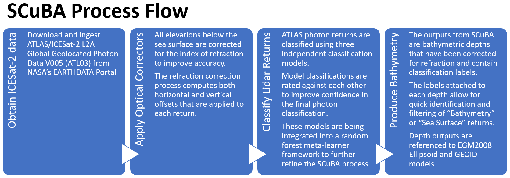
4 Operational process
The SCuBA project has developed an operational process that prepares ATL03 Global Geolocated Photon Data products available from NASA to optically correct and classify shallow ocean photon returns into accurate depths required for hydrographic purposes (Fig. 1). This pipeline begins with the retrieval of ATL03 files from NASA’s repository hosted by the National Snow and Ice Data Center or their newer Amazon Web Service cloud repository. The ATL03 files comprise geolocated photon event data from the ATLAS suite along the orbital track of ICESat-2 in HDF5 format (Neumann et al., 2021). These files are acquired along tracks that cover areas of interest for bathymetry queries and are processed in a supercomputing environment that supports parallel processing. The SCuBA algorithm applies optical corrections (Parrish et al., 2019) and three independent photon classification models are to produce classified SCuBA depth values. Classified depths which coincide between multiple models are ascribed greater weight, and the final depth data reflects those classified depths based on a user-defined model agreement threshold. The final product includes photon classifications of “seafloor”, “sea surface”, and “water column”. Current development is integrating these models into a random forest meta-learner structure to improve the photon classification capabilities. SCuBA data can serve as an independent source of hydrographic data, a benchmark for less accurate hydrographic sources, or a seed for empirical models producing SDB from multispectral imagery.
4.1 Proof of concept
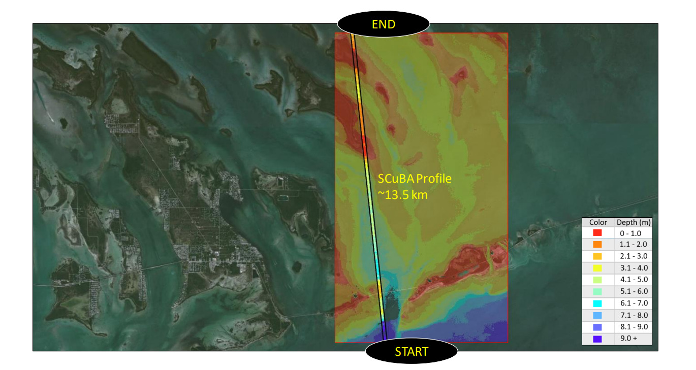
Preliminary work applying the SCuBA algorithm to areas around the global ocean have revealed both impressive depth retrieval capabilities as well as continuing challenges that limit the utility of SCuBA under certain conditions. One such area of examination is the Florida Keys, an archipelago of Pleistocene age coral reef cays which spans from the southern tip of the Florida peninsula to Dry Tortugas. The Florida Keys present a uniquely ideal site to test SCuBA derived depths against traditional airborne bathymetric lidar covering coastal seafloor areas within the extinction depth of light and which are relatively optically clear (He et al., 2017).
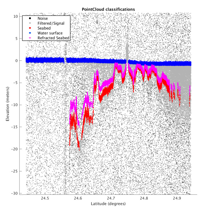
Our comparison of SCuBA derived depths with traditional airborne bathymetric lidar survey of the Florida Keys collected by the National Geodetic Survey (NGS), under the authority of the National Oceanic and Atmospheric Administration (NOAA) following Hurricane Irma (NGS, 2019), revealed substantially similar depths (Fig. 2). Comparing SCuBA depths (Fig. 3) with those from the NGS survey reveal a mean vertical error that is less than 0.09 m and within 3.6 % of the depth. Classification uncertainty close to the sea surface presents the largest contributor to that error, with vertical error throughout the water column remaining relatively uniform with depth. Empirical methods of satellite bathymetry estimation using multispectral imagery boast sub-meter root mean squared errors, however, the effective vertical accuracy of these techniques is presently on the order of meters to tens of meters, and highly sensitive to unique environmental characteristics of the areas these techniques are applied to (Ashphaq et al., 2021).
4.2 Challenges
SCuBA, as previously mentioned, presents a compelling source of bathymetric data in suitable shallow ocean environments. However, there are existing challenges that reduce the utility and degrade the error budget of SCuBA data. Many of these challenges are shared among multispectral bathymetry techniques, such as the ultimate extinction depth of light in the water column, sensitivity to sediment and dissolved organic materials in the water column, sea surface roughness, and lidar-angle of incidence issues prevalent in the high-latitudes (Jawak et al., 2015; Quan, 2021). Initial testing and assessment of SCuBA data in areas of ideal water column conditions have revealed vertical error budgets on the order of tens of centimeters, with exemplars from the Florida Keys presented here returning a mean depth error under 3.6 % of the depth and a mean absolute error budget ranging from 0 m to 0.4 m at the 2-sigma level as compared to traditional airborne bathymetric lidar. Similar testing in less ideal environments, with exemplars from the North Carolina coast, has returned mean average depth errors around 0.6 m to 0.8 m relative to traditional airborne bathymetric lidar (Walker et al., 2020). Other less than ideal environments, such as those around the poles, continue to present challenges to accurate depth retrieval (Walker et al., 2020). With the above challenges considered, SCuBA is revealing that in areas where it can be successfully produced it presents improved vertical accuracy relative to imagery based SDB and that continued development of algorithms and processes to improve satellite lidar depth data is a worthwhile effort for safety of navigation applications.
5 Future Directions and recommendations
The depth data SCuBA produces from ATLAS satellite lidar data demonstrates improved vertical accuracy relative to imagery-based bathymetry methods (Walker et al., 2020). Unfortunately, unlike methods that use multispectral imagery, it lacks contiguous spatial resolution (Babbel et al., 2021). The ATLAS lidar on ICESat-2 employs beam splitters to arrange the laser into three beam-pairs. Each beam pair is separated from each other by 90 m and from adjacent pairs by 3.3 km (NASA, 2019). This results in data from an orbital pass of any given area of interest comprising six linear transects of discrete values, rather than a contiguous matrix of values across the area. While over time the density of orbital transit lines may increase spatial coverage and data density in an area, the spatial gaps between transit lines are substantial relative to high-resolution multispectral imagery from systems aboard satellites such as the European Space Agency’s Worldview-3 satellite.
To improve both data quality and coverage, fusing space-based lidar with other SDB techniques using multispectral imagery has been shown to add value to both types of data for hydrographic purposes (Babbel et al., 2021; Ma et al., 2020). Developing new photon classification techniques to better combine the improved vertical accuracy of ICESat-2 depth data like SCuBA with the spatial resolution of imagery derived SDB should be pursued to further enhance the utility of SDB for safety of navigation purposes.
6 Conclusions
The shortage of bathymetric data for navigational purposes has long posed a challenge for hydrographic offices and institutions around the world (IHO DCDB, 2023). Satellite derived bathymetry in coastal ocean waters has presented an opportunity to improve depth data coverage in areas that are challenging or costly to survey using traditional methods, however, many existing satellite-based techniques suffered from vertical accuracy limits which hinder their application to navigational products and charts (Mavraeidopoulos et al., 2017). Our work has found that applying multi-model classification schemes to ATLAS lidar produces high quality depth data that can be used in safety of navigation products. Continued development of advanced algorithms to improve spaceborne lidar bathymetry is an important step in completely mapping the Earth’s oceans, and ensuring nautical chart products serve their purpose and keep mariners appraised of hazards at sea.
Acknowledgments
We gratefully acknowledge the substantial contributions of Dr. Monique Walker and her team in NGA Research for their incredible work developing SCuBA. We also gratefully acknowledge the tremendous effort our colleagues at NASA and its affiliated institutions have made in the ICESat-2 mission’s scientific products, especially the team behind the ATL03 data product.
References
Ashphaq, M., Srivastava, P. K. and Mitra, D. (2021). Review of near-shore satellite derived bathymetry: Classification and account of five decades of coastal bathymetry research. Journal of Ocean Engineering and Science, 6(4) , 340–359.
Babbel, B. J., Parrish, C. E. and Magruder, L. A. (2021). ICESat-2 Elevation Retrievals in Support of Satellite-Derived Bathymetry for Global Science Applications. Geophysical Research Letters, 48.
Ceyhun, Ö. and Yalçın, A. (2010). Remote sensing of water depths in shallow waters via artificial neural networks.Estuarine, Coastal and Shelf Science, 89(1) , 89–96.
He, X. et al. (2017). Recent changes of global ocean transparency observed by SeaWiFS. Continental Shelf Research, 143, 159–166.
IHO DCDB (2023). IHO Data Centre for Digital Bathymetry (DCDB). https://www.ngdc.noaa.gov/iho/ (accessed 13 Mar. 2023)
Jawak, S. D., Vadlamani, S. S. and Luis, A. J. (2015). A Synoptic Review on Deriving Bathymetry Information Using Remote Sensing Technologies: Models, Methods and Comparisons. Advances in Remote Sensing, 4(2) , 147–162.
Laporte, J., Dolou, H., Avis, J. and Arino, O. (2020). Thirty years of satellite derived bathymetry – The charting tool that hydrographers can no longer ignore. The International Hydrographic Review, 24, 129–154.
Mavraeidopoulos, A. K., Pallikaris, A. and Oikonomou, E. (2017). Satellite Derived Bathymetry (SDB) and Safety of Navigation. The International Hydrographic Review, 17, 7–19.
Ma, Y. et al. (2020). Satellite-derived bathymetry using the ICESat-2 lidar and Sentinel-2 imagery datasets. Remote Sensing of Environment, 250, 112047.
NASA (2019). Technical Specs | ICESat-2. https://icesat-2.gsfc. nasa.gov/science/specs (accessed 13 Mar. 2023). Neumann, T., Brenner, A., Hancock, D. et al. (2021). ICE, CLOUD, and Land Elevation Satellite (ICESat-2) Project – Algorithm Theoretical Basis Document (ATBD) for Global Geolocated Photons
ATL03. https://icesat-2.gsfc.nasa.gov/sites/default/files/page_ files/ICESat2_ATL03_ATBD_r005.pdf (accessed 22 Sep. 2023). NGS (2019). 2018-2019 NOAA NGS Topobathy Lidar Hurricane Irma: Miami to Marquesas Keys, FL. https://www.fisheries.noaa. gov/inport/item/63017 (accessed 10 May 2023).
Nippon Foundation – GEBCO, 2021. Seabed2030. www.seabed2030.org (accessed 6 Jan. 2022).
Parrish, C. E. et al., 2019. Validation of ICESat-2 ATLAS Bathymetry and Analysis of ATLAS’s Bathymetric Mapping Performance. Remote Sensing, 11(14) , 1634.
Quan, S. (2021). Improving Optical Bathymetry Estimation with Constrained Geographically Weighted Regression Using Object-Based Image Analysis. Dissertation, George Mason University, Fairfax, VA, USA. http://hdl.handle.net/1920/12706
Rehman, H. U., Nakaya, H. and Kawai, K. (2013). Geological origin of the volcanic islands of the Caroline Group in the Federated States of Micronesia, Western Pacific. South Pacific Studies, 33(2) , 101–118.
Su, H. et al. (2014). Geographically Adaptive Inversion Model for Improving Bathymetric Retrieval From Satellite Multispectral Imagery. IEEE Transactions on Geoscience and Remote Sensing, 52(1) , 465–476.
Walker, M., Magruder, L., Neuenschwander, A. and Klotz, B., 2020. Satellite Computed Bathymetry Assessment-SCuBA. AGU Fall Meeting Abstracts, 2020, C030-0020.